Aš elevation
Aš (Karlovarský kraj, Okres Cheb), Czech Republic elevation is 676 meters and Aš elevation in feet is 2218 ft above sea level [src 1]. Aš is a populated place (feature code) with elevation that is 331 meters (1086 ft) bigger than average city elevation in Czech Republic.
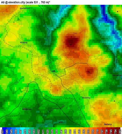
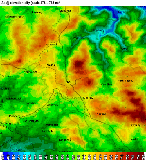
Below is the Elevation map of Aš, which displays elevation range with different colors. Scale of the first map is from 531 to 763 m (1742 to 2503 ft) with average elevation of 644.8 meters (=2115 ft) [note 1]
These maps also provides idea of topography and contour of this city, they are displayed at different zoom levels. More info about maps, scale and edge coordinates you can find below images.
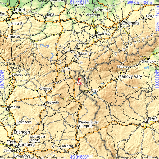
| \ | Map #1 | Map #2 | Topo.Map |
| Scale [m] | 531..763 m | 478..763 m | × |
| Scale [ft] | 1742..2503 ft | 1568..2503 ft | × |
| Average | 644.8 m = 2115 ft | 628.9 m = 2063 ft | × |
| Width | 6.25 km = 3.9 mi | 12.5 km = 7.8 mi | 200.1 km = 124.3 mi |
| Height | 6.25 km = 3.9 mi | 12.5 km = 7.8 mi | 200.1 km = 124.3 mi |
| ↑Max Latitude | 50.251977° | 50.280068° | 51.11511° |
| Latitude at center | 50.22387° | 50.22387° | 50.22387° |
| ↓Min Latitude | 50.195746° | 50.167605° | 49.31566° |
| ← Min Longitude | 12.151045° | 12.107099° | 10.78874° |
| Longitude center | 12.19499° | 12.19499° | 12.19499° |
| →Max Longitude | 12.238935° | 12.282881° | 13.60124° |
Nearby cities:
Cities around Aš sort by population:
• Cheb elevation 445 m
20.5 km,  141°
141°
• Kraslice 515 m
25.5 km,  64°
64°
• Františkovy Lázně 448 m
16 km, 135°
• Habartov 504 m
25.7 km,  100°
100°
• Kynšperk nad Ohří 441 m
26.6 km,  116°
116°
• Luby 524 m
15.3 km,  78°
78°
• Hranice 580 m
9.1 km,  351°
351°
• Plesná 501 m
10.8 km,  91°
91°
• Skalná 461 m
13.3 km, 116°
• Oloví 476 m
26 km, 83°
• Bukovany 455 m
27.6 km, 103°
• Hazlov 541 m
9.3 km, 143°
Multilingual:
 En español:
Aš elevación 676 m.
 En France:
Aš élévation 676 m.


Sources and notes:
- [note 1] Map square and city borders are not equal. Map elevation data is calculated only from area inside that square.
- [src 1] Elevation data from geonames database provided with same terms of usage.
- [src 2] The elevation map of Aš is generated using elevation data from NASA's 3 arcsec (90m) resolution SRTM data.
- [src 3] Base (background) map © OpenStreetMap contributors tiles are generated by Geofabrik and OpenTopoMap.
Copyright & License:
This Aš Elevation Map is licensed under CC BY-SA. You may reuse any part from this page, if you give a proper credit by linking to this URL:
 More info on terms of use page.