Bechyně elevation
Bechyně (Jihočeský kraj, Okres Tábor), Czech Republic elevation is 407 meters and Bechyně elevation in feet is 1335 ft above sea level [src 1]. Bechyně is a populated place (feature code) with elevation that is 62 meters (203 ft) bigger than average city elevation in Czech Republic.
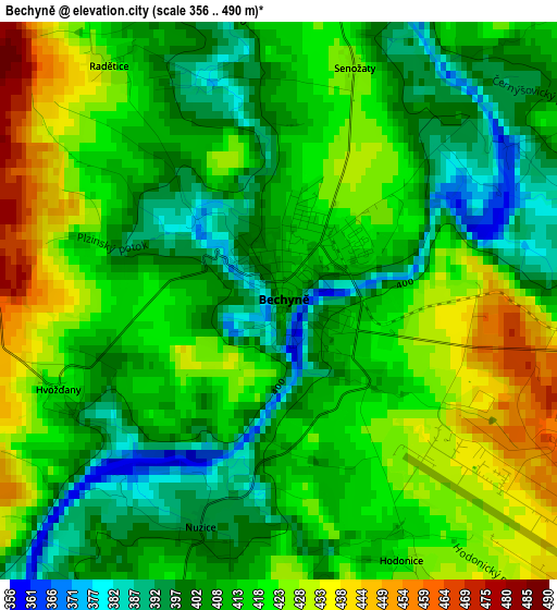
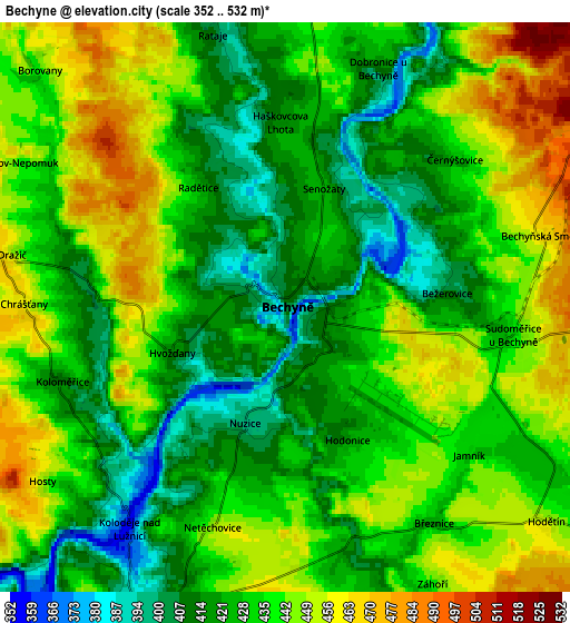
Below is the Elevation map of Bechyně, which displays elevation range with different colors. Scale of the first map is from 356 to 490 m (1168 to 1608 ft) with average elevation of 413.7 meters (=1357 ft) [note 1]
These maps also provides idea of topography and contour of this city, they are displayed at different zoom levels. More info about maps, scale and edge coordinates you can find below images.
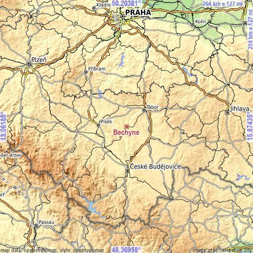
| \ | Map #1 | Map #2 | Topo.Map |
| Scale [m] | 356..490 m | 352..532 m | × |
| Scale [ft] | 1168..1608 ft | 1155..1745 ft | × |
| Average | 413.7 m = 1357 ft | 433 m = 1421 ft | × |
| Width | 6.37 km = 4 mi | 12.75 km = 7.9 mi | 203.9 km = 126.7 mi |
| Height | 6.37 km = 4 mi | 12.75 km = 7.9 mi | 203.9 km = 126.7 mi |
| ↑Max Latitude | 49.323881° | 49.352516° | 50.20381° |
| Latitude at center | 49.29523° | 49.29523° | 49.29523° |
| ↓Min Latitude | 49.266562° | 49.237878° | 48.36958° |
| ← Min Longitude | 14.424155° | 14.380209° | 13.06185° |
| Longitude center | 14.4681° | 14.4681° | 14.4681° |
| →Max Longitude | 14.512045° | 14.555991° | 15.87435° |
Nearby cities:
Cities around Bechyně sort by population:
• Tábor elevation 456 m
19.1 km,  46°
46°
• Milevsko 457 m
19 km,  335°
335°
• Týn nad Vltavou 368 m
8.7 km,  203°
203°
• Sezimovo Ústí 400 m
18.6 km,  57°
57°
• Soběslav 408 m
18.6 km,  102°
102°
• Planá nad Lužnicí 396 m
18.1 km,  68°
68°
• Malšice 498 m
11.1 km, 46°
• Dolní Bukovsko 445 m
16.1 km,  149°
149°
• Dřiteň 435 m
19.1 km,  207°
207°
• Opařany 469 m
11.3 km,  4°
4°
• Sepekov 450 m
15.3 km,  346°
346°
• Bernartice 462 m
10.3 km,  322°
322°
Multilingual:
 En español:
Bechyně elevación 407 m.
 En France:
Bechyně élévation 407 m.


Sources and notes:
- [note 1] Map square and city borders are not equal. Map elevation data is calculated only from area inside that square.
- [src 1] Elevation data from geonames database provided with same terms of usage.
- [src 2] The elevation map of Bechyně is generated using elevation data from NASA's 3 arcsec (90m) resolution SRTM data.
- [src 3] Base (background) map © OpenStreetMap contributors tiles are generated by Geofabrik and OpenTopoMap.
Copyright & License:
This Bechyně Elevation Map is licensed under CC BY-SA. You may reuse any part from this page, if you give a proper credit by linking to this URL:
 More info on terms of use page.