Benešov elevation
Benešov (Central Bohemia, Okres Benešov), Czech Republic elevation is 357 meters and Benešov elevation in feet is 1171 ft above sea level [src 1]. Benešov is a populated place (feature code) with elevation that is 12 meters (39 ft) bigger than average city elevation in Czech Republic.
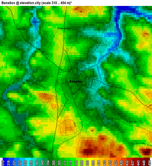
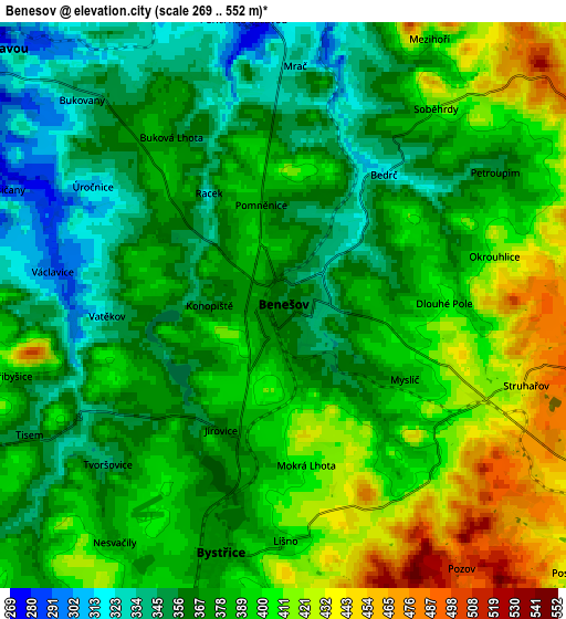
Below is the Elevation map of Benešov, which displays elevation range with different colors. Scale of the first map is from 310 to 454 m (1017 to 1490 ft) with average elevation of 371.9 meters (=1220 ft) [note 1]
These maps also provides idea of topography and contour of this city, they are displayed at different zoom levels. More info about maps, scale and edge coordinates you can find below images.
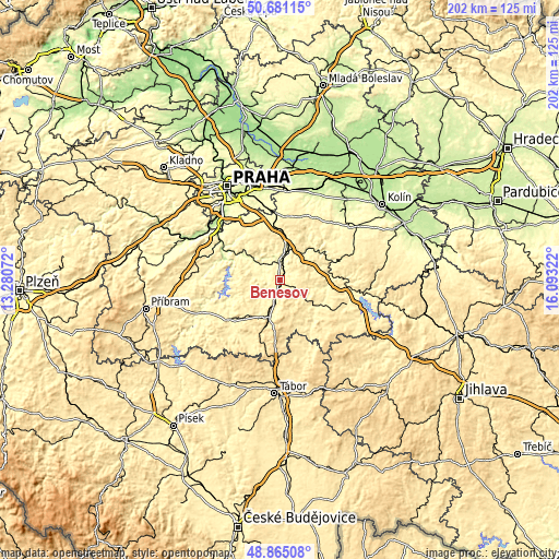
| \ | Map #1 | Map #2 | Topo.Map |
| Scale [m] | 310..454 m | 269..552 m | × |
| Scale [ft] | 1017..1490 ft | 883..1811 ft | × |
| Average | 371.9 m = 1220 ft | 383.1 m = 1257 ft | × |
| Width | 6.31 km = 3.9 mi | 12.62 km = 7.8 mi | 201.9 km = 125.5 mi |
| Height | 6.31 km = 3.9 mi | 12.62 km = 7.8 mi | 201.9 km = 125.5 mi |
| ↑Max Latitude | 49.809987° | 49.838338° | 50.68115° |
| Latitude at center | 49.78162° | 49.78162° | 49.78162° |
| ↓Min Latitude | 49.753236° | 49.724836° | 48.86508° |
| ← Min Longitude | 14.643025° | 14.599079° | 13.28072° |
| Longitude center | 14.68697° | 14.68697° | 14.68697° |
| →Max Longitude | 14.730915° | 14.774861° | 16.09322° |
Nearby cities:
Cities around Benešov sort by population:
• Týnec nad Sázavou elevation 267 m
9 km,  309°
309°
• Bystřice 372 m
5.7 km,  194°
194°
• Kamenice 381 m
15.3 km,  330°
330°
• Čerčany 284 m
8 km,  8°
8°
• Neveklov 412 m
11.5 km,  254°
254°
• Divišov 468 m
13.6 km,  86°
86°
• Pyšely 372 m
10.6 km,  356°
356°
• Kamenný Přívoz 236 m
16 km,  304°
304°
• Postupice 419 m
8.8 km,  132°
132°
• Ondřejov 480 m
15.3 km,  27°
27°
• Netvořice 358 m
12.7 km,  287°
287°
• Poříčí nad Sázavou 273 m
6.4 km,  351°
351°
Multilingual:
 En español:
Benešov elevación 357 m.
 En France:
Benešov élévation 357 m.


Sources and notes:
- [note 1] Map square and city borders are not equal. Map elevation data is calculated only from area inside that square.
- [src 1] Elevation data from geonames database provided with same terms of usage.
- [src 2] The elevation map of Benešov is generated using elevation data from NASA's 3 arcsec (90m) resolution SRTM data.
- [src 3] Base (background) map © OpenStreetMap contributors tiles are generated by Geofabrik and OpenTopoMap.
Copyright & License:
This Benešov Elevation Map is licensed under CC BY-SA. You may reuse any part from this page, if you give a proper credit by linking to this URL:
 More info on terms of use page.