Divišov elevation
Divišov (Central Bohemia, Okres Benešov), Czech Republic elevation is 468 meters and Divišov elevation in feet is 1535 ft above sea level [src 1]. Divišov is a populated place (feature code) with elevation that is 123 meters (404 ft) bigger than average city elevation in Czech Republic.
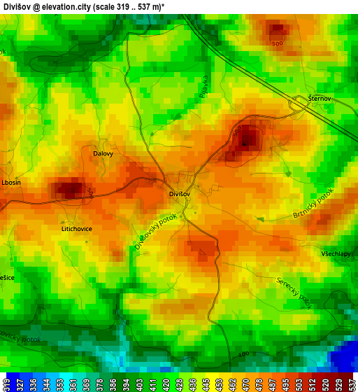
Below is the Elevation map of Divišov, which displays elevation range with different colors. Scale of the first map is from 319 to 537 m (1047 to 1762 ft) with average elevation of 440.8 meters (=1446 ft) [note 1]
These maps also provides idea of topography and contour of this city, they are displayed at different zoom levels. More info about maps, scale and edge coordinates you can find below images.
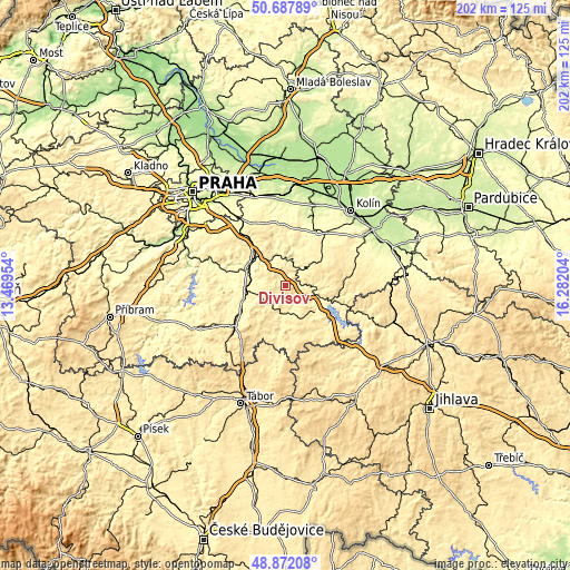
| \ | Map #1 | Topo.Map |
| Scale [m] | 319..537 m | × |
| Scale [ft] | 1047..1762 ft | × |
| Average | 440.8 m = 1446 ft | × |
| Width | 6.31 km = 3.9 mi | 201.9 km = 125.5 mi |
| Height | 6.31 km = 3.9 mi | 201.9 km = 125.5 mi |
| ↑Max Latitude | 49.816853° | 50.68789° |
| Latitude at center | 49.78849° | 49.78849° |
| ↓Min Latitude | 49.76011° | 48.87208° |
| ← Min Longitude | 14.831845° | 13.46954° |
| Longitude center | 14.87579° | 14.87579° |
| →Max Longitude | 14.919735° | 16.28204° |
Nearby cities:
Cities around Divišov sort by population:
• Benešov elevation 357 m
13.6 km,  266°
266°
• Vlašim 370 m
9.3 km,  169°
169°
• Zruč nad Sázavou 337 m
17.4 km,  108°
108°
• Bystřice 372 m
16.2 km,  247°
247°
• Sázava 291 m
9.4 km,  9°
9°
• Uhlířské Janovice 424 m
17 km,  53°
53°
• Čerčany 284 m
14.3 km,  300°
300°
• Trhový Štěpánov 416 m
13.1 km,  130°
130°
• Pyšely 372 m
17.3 km, 304°
• Postupice 419 m
9.8 km,  226°
226°
• Ondřejov 480 m
14.5 km,  333°
333°
• Poříčí nad Sázavou 273 m
15.5 km,  291°
291°
Multilingual:
 En español:
Divišov elevación 468 m.
 En France:
Divišov élévation 468 m.


Sources and notes:
- [note 1] Map square and city borders are not equal. Map elevation data is calculated only from area inside that square.
- [src 1] Elevation data from geonames database provided with same terms of usage.
- [src 2] The elevation map of Divišov is generated using elevation data from NASA's 3 arcsec (90m) resolution SRTM data.
- [src 3] Base (background) map © OpenStreetMap contributors tiles are generated by Geofabrik and OpenTopoMap.
Copyright & License:
This Divišov Elevation Map is licensed under CC BY-SA. You may reuse any part from this page, if you give a proper credit by linking to this URL:
 More info on terms of use page.