Brtnice elevation
Brtnice (Vysočina, Okres Jihlava), Czech Republic elevation is 518 meters and Brtnice elevation in feet is 1699 ft above sea level [src 1]. Brtnice is a populated place (feature code) with elevation that is 173 meters (568 ft) bigger than average city elevation in Czech Republic.
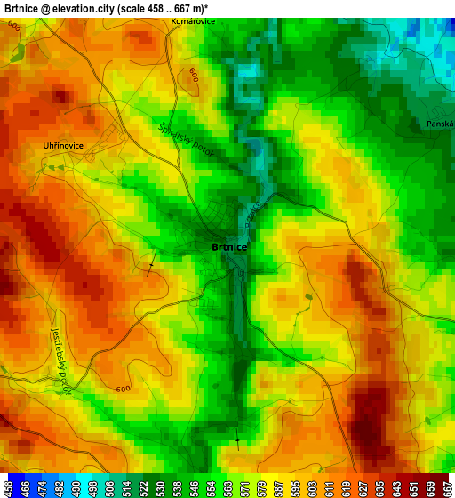
Below is the Elevation map of Brtnice, which displays elevation range with different colors. Scale of the first map is from 458 to 667 m (1503 to 2188 ft) with average elevation of 578.9 meters (=1899 ft) [note 1]
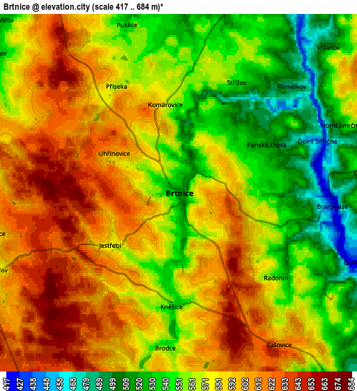
These maps also provides idea of topography and contour of this city, they are displayed at different zoom levels. More info about maps, scale and edge coordinates you can find below images.
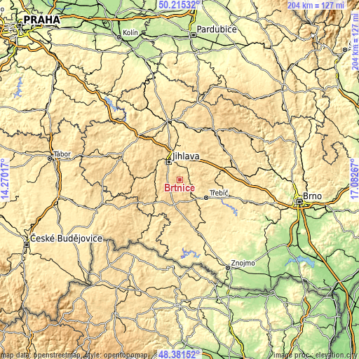
| \ | Map #1 | Map #2 | Topo.Map |
| Scale [m] | 458..667 m | 417..684 m | × |
| Scale [ft] | 1503..2188 ft | 1368..2244 ft | × |
| Average | 578.9 m = 1899 ft | 575.8 m = 1889 ft | × |
| Width | 6.37 km = 4 mi | 12.74 km = 7.9 mi | 203.9 km = 126.7 mi |
| Height | 6.37 km = 4 mi | 12.74 km = 7.9 mi | 203.9 km = 126.7 mi |
| ↑Max Latitude | 49.335594° | 49.364222° | 50.21532° |
| Latitude at center | 49.30695° | 49.30695° | 49.30695° |
| ↓Min Latitude | 49.278289° | 49.249611° | 48.38152° |
| ← Min Longitude | 15.632475° | 15.588529° | 14.27017° |
| Longitude center | 15.67642° | 15.67642° | 15.67642° |
| →Max Longitude | 15.720365° | 15.764311° | 17.08267° |
Nearby cities:
Cities around Brtnice sort by population:
• Jihlava elevation 523 m
11.7 km,  328°
328°
• Třebíč 405 m
18.1 km,  124°
124°
• Třešť 550 m
14.2 km,  262°
262°
• Luka nad Jihlavou 447 m
7.7 km,  13°
13°
• Okříšky 477 m
9.6 km,  135°
135°
• Měřín 490 m
17.8 km,  57°
57°
• Kamenice 521 m
10 km,  48°
48°
• Želetava 575 m
18.4 km,  180°
180°
• Stařeč 453 m
16.4 km, 137°
• Kněžice 547 m
4 km, 184°
• Velký Beranov 530 m
10.9 km,  356°
356°
• Dolní Cerekev 533 m
16.5 km,  284°
284°
Multilingual:
 En español:
Brtnice elevación 518 m.
 En France:
Brtnice élévation 518 m.


Sources and notes:
- [note 1] Map square and city borders are not equal. Map elevation data is calculated only from area inside that square.
- [src 1] Elevation data from geonames database provided with same terms of usage.
- [src 2] The elevation map of Brtnice is generated using elevation data from NASA's 3 arcsec (90m) resolution SRTM data.
- [src 3] Base (background) map © OpenStreetMap contributors tiles are generated by Geofabrik and OpenTopoMap.
Copyright & License:
This Brtnice Elevation Map is licensed under CC BY-SA. You may reuse any part from this page, if you give a proper credit by linking to this URL:
 More info on terms of use page.