Děčín elevation
Děčín (Ústecký kraj, Okres Děčín), Czech Republic elevation is 138 meters and Děčín elevation in feet is 453 ft above sea level [src 1]. Děčín is a populated place (feature code) with elevation that is 207 meters (679 ft) smaller than average city elevation in Czech Republic.
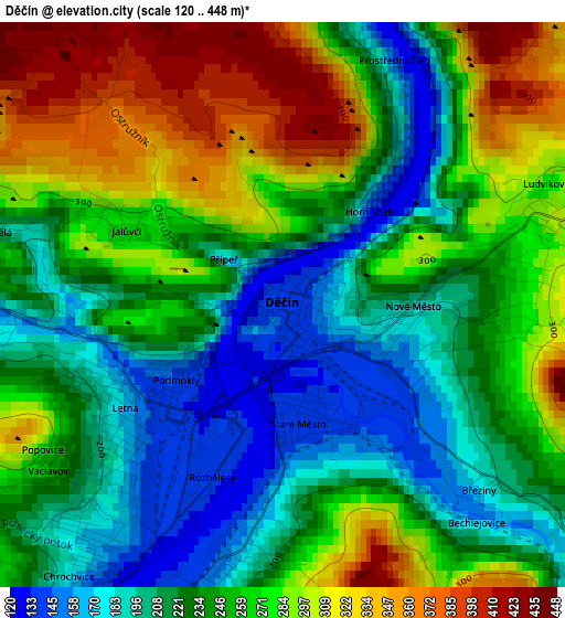
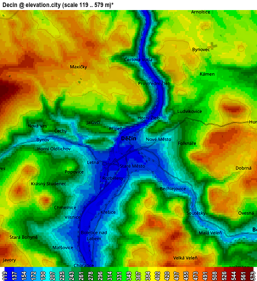
Below is the Elevation map of Děčín, which displays elevation range with different colors. Scale of the first map is from 120 to 448 m (394 to 1470 ft) with average elevation of 249.4 meters (=818 ft) [note 1]
These maps also provides idea of topography and contour of this city, they are displayed at different zoom levels. More info about maps, scale and edge coordinates you can find below images.
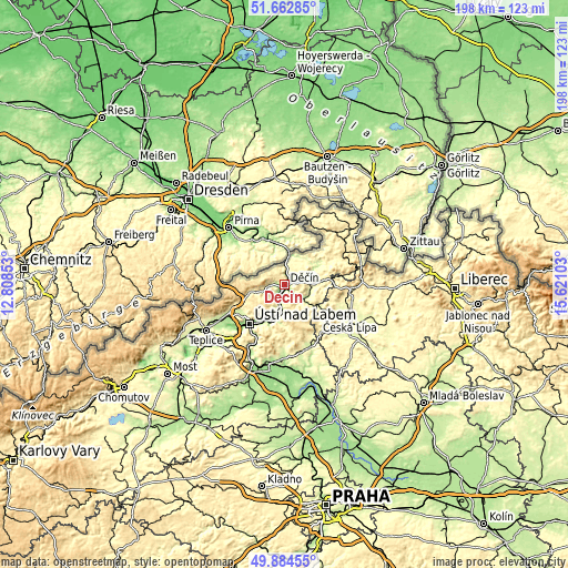
| \ | Map #1 | Map #2 | Topo.Map |
| Scale [m] | 120..448 m | 119..579 m | × |
| Scale [ft] | 394..1470 ft | 390..1900 ft | × |
| Average | 249.4 m = 818 ft | 330.3 m = 1084 ft | × |
| Width | 6.18 km = 3.8 mi | 12.36 km = 7.7 mi | 197.7 km = 122.8 mi |
| Height | 6.18 km = 3.8 mi | 12.36 km = 7.7 mi | 197.7 km = 122.8 mi |
| ↑Max Latitude | 50.809927° | 50.837688° | 51.66285° |
| Latitude at center | 50.78215° | 50.78215° | 50.78215° |
| ↓Min Latitude | 50.754356° | 50.726546° | 49.88455° |
| ← Min Longitude | 14.170835° | 14.126889° | 12.80853° |
| Longitude center | 14.21478° | 14.21478° | 14.21478° |
| →Max Longitude | 14.258725° | 14.302671° | 15.62103° |
Nearby cities:
Cities around Děčín sort by population:
• Ústí nad Labem elevation 150 m
18.6 km,  223°
223°
• Česká Kamenice 313 m
14.4 km,  83°
83°
• Jílové 265 m
8.2 km,  253°
253°
• Chlumec 243 m
21.4 km,  244°
244°
• Benešov nad Ploučnicí 212 m
8.2 km,  123°
123°
• Kamenický Šenov 528 m
18.2 km,  93°
93°
• Povrly 148 m
12.8 km,  197°
197°
• Velké Březno 148 m
14.2 km, 201°
• Žandov 258 m
14.8 km, 120°
• Libouchec 338 m
12.5 km,  257°
257°
• Chřibská 352 m
20.9 km,  65°
65°
• Verneřice 497 m
14.8 km,  155°
155°
Multilingual:
 En español:
Děčín elevación 138 m.
 En France:
Děčín élévation 138 m.
 Auf Deutsch:
Tetschen, Děčín höhe über dem Meeresspiegel ist 138 m.

Sources and notes:
- [note 1] Map square and city borders are not equal. Map elevation data is calculated only from area inside that square.
- [src 1] Elevation data from geonames database provided with same terms of usage.
- [src 2] The elevation map of Děčín is generated using elevation data from NASA's 3 arcsec (90m) resolution SRTM data.
- [src 3] Base (background) map © OpenStreetMap contributors tiles are generated by Geofabrik and OpenTopoMap.
Copyright & License:
This Děčín Elevation Map is licensed under CC BY-SA. You may reuse any part from this page, if you give a proper credit by linking to this URL:
 More info on terms of use page.