Domažlice elevation
Domažlice (Plzeňský kraj, Okres Domažlice), Czech Republic elevation is 432 meters and Domažlice elevation in feet is 1417 ft above sea level [src 1]. Domažlice is a populated place (feature code) with elevation that is 87 meters (285 ft) bigger than average city elevation in Czech Republic.
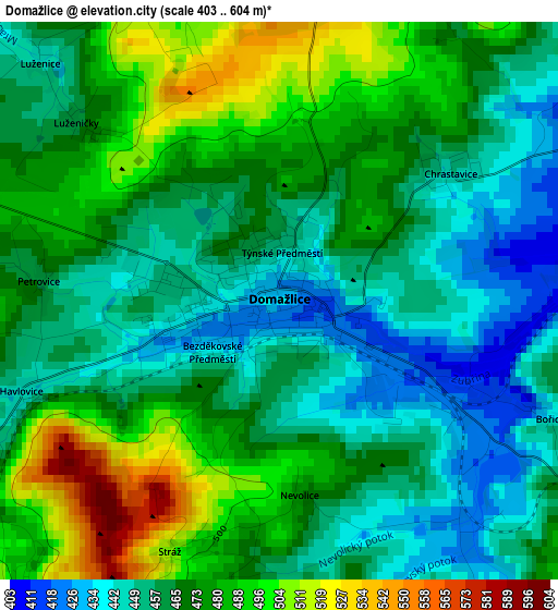
Below is the Elevation map of Domažlice, which displays elevation range with different colors. Scale of the first map is from 403 to 604 m (1322 to 1982 ft) with average elevation of 468 meters (=1535 ft) [note 1]
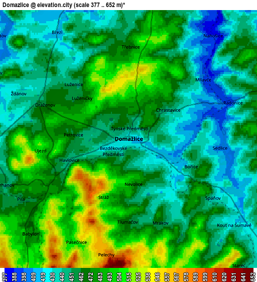
These maps also provides idea of topography and contour of this city, they are displayed at different zoom levels. More info about maps, scale and edge coordinates you can find below images.
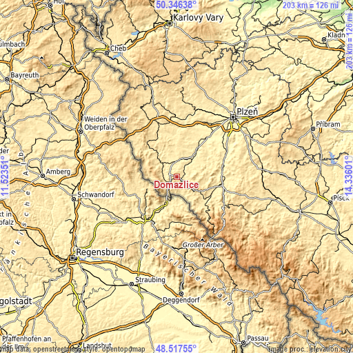
| \ | Map #1 | Map #2 | Topo.Map |
| Scale [m] | 403..604 m | 377..652 m | × |
| Scale [ft] | 1322..1982 ft | 1237..2139 ft | × |
| Average | 468 m = 1535 ft | 466.6 m = 1531 ft | × |
| Width | 6.35 km = 3.9 mi | 12.71 km = 7.9 mi | 203.3 km = 126.3 mi |
| Height | 6.35 km = 3.9 mi | 12.71 km = 7.9 mi | 203.3 km = 126.3 mi |
| ↑Max Latitude | 49.469057° | 49.497606° | 50.34638° |
| Latitude at center | 49.44049° | 49.44049° | 49.44049° |
| ↓Min Latitude | 49.411907° | 49.383307° | 48.51755° |
| ← Min Longitude | 12.885815° | 12.841869° | 11.52351° |
| Longitude center | 12.92976° | 12.92976° | 12.92976° |
| →Max Longitude | 12.973705° | 13.017651° | 14.33601° |
Nearby cities:
Cities around Domažlice sort by population:
• Kdyně elevation 460 m
9.7 km,  124°
124°
• Horšovský Týn 383 m
10 km,  5°
5°
• Holýšov 367 m
21.1 km,  36°
36°
• Staňkov 359 m
16.1 km, 38°
• Poběžovice 430 m
12 km,  310°
310°
• Hostouň 448 m
17.5 km,  319°
319°
• Klenčí pod Čerchovem 497 m
8.3 km,  265°
265°
• Mrákov 461 m
4.4 km,  159°
159°
• Kout na Šumavě 425 m
6.7 km,  128°
128°
• Postřekov 463 m
9.1 km,  282°
282°
• Meclov 391 m
8.1 km,  333°
333°
• Blížejov 384 m
7.9 km,  33°
33°
Multilingual:
 En español:
Domažlice elevación 432 m.
 En France:
Domažlice élévation 432 m.


Sources and notes:
- [note 1] Map square and city borders are not equal. Map elevation data is calculated only from area inside that square.
- [src 1] Elevation data from geonames database provided with same terms of usage.
- [src 2] The elevation map of Domažlice is generated using elevation data from NASA's 3 arcsec (90m) resolution SRTM data.
- [src 3] Base (background) map © OpenStreetMap contributors tiles are generated by Geofabrik and OpenTopoMap.
Copyright & License:
This Domažlice Elevation Map is licensed under CC BY-SA. You may reuse any part from this page, if you give a proper credit by linking to this URL:
 More info on terms of use page.