Hošťálková elevation
Hošťálková (Zlín, Okres Vsetín), Czech Republic elevation is 378 meters and Hošťálková elevation in feet is 1240 ft above sea level [src 1]. Hošťálková is a populated place (feature code) with elevation that is 33 meters (108 ft) bigger than average city elevation in Czech Republic.
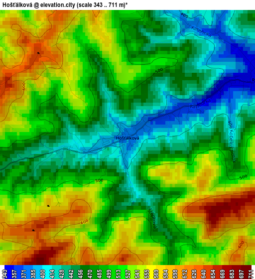
Below is the Elevation map of Hošťálková, which displays elevation range with different colors. Scale of the first map is from 343 to 711 m (1125 to 2333 ft) with average elevation of 503.9 meters (=1653 ft) [note 1]
These maps also provides idea of topography and contour of this city, they are displayed at different zoom levels. More info about maps, scale and edge coordinates you can find below images.
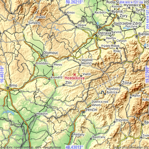
| \ | Map #1 | Topo.Map |
| Scale [m] | 343..711 m | × |
| Scale [ft] | 1125..2333 ft | × |
| Average | 503.9 m = 1653 ft | × |
| Width | 6.37 km = 4 mi | 203.7 km = 126.6 mi |
| Height | 6.37 km = 4 mi | 203.7 km = 126.6 mi |
| ↑Max Latitude | 49.383287° | 50.26215° |
| Latitude at center | 49.35467° | 49.35467° |
| ↓Min Latitude | 49.326037° | 48.43013° |
| ← Min Longitude | 17.825495° | 16.46319° |
| Longitude center | 17.86944° | 17.86944° |
| →Max Longitude | 17.913385° | 19.27569° |
Nearby cities:
Cities around Hošťálková sort by population:
• Vsetín elevation 346 m
9.4 km,  100°
100°
• Slušovice 275 m
12.9 km,  202°
202°
• Kelč 349 m
14.3 km,  344°
344°
• Jablůnka 321 m
6.7 km,  61°
61°
• Lukov 310 m
12.4 km,  234°
234°
• Ratiboř 341 m
3.6 km,  66°
66°
• Chvalčov 378 m
12.1 km,  288°
288°
• Liptál 430 m
8.1 km,  152°
152°
• Valašská Polanka 388 m
13.8 km,  138°
138°
• Trnava 345 m
6.8 km, 197°
• Hvozdná 287 m
14.6 km,  215°
215°
• Všemina 385 m
8.2 km,  176°
176°
Multilingual:
 En español:
Hošťálková elevación 378 m.
 En France:
Hošťálková élévation 378 m.
 Auf Deutsch:
Hošťálková höhe über dem Meeresspiegel ist 378 m.

Sources and notes:
- [note 1] Map square and city borders are not equal. Map elevation data is calculated only from area inside that square.
- [src 1] Elevation data from geonames database provided with same terms of usage.
- [src 2] The elevation map of Hošťálková is generated using elevation data from NASA's 3 arcsec (90m) resolution SRTM data.
- [src 3] Base (background) map © OpenStreetMap contributors tiles are generated by Geofabrik and OpenTopoMap.
Copyright & License:
This Hošťálková Elevation Map is licensed under CC BY-SA. You may reuse any part from this page, if you give a proper credit by linking to this URL:
 More info on terms of use page.