Hvozdná elevation
Hvozdná (Zlín, Okres Zlín), Czech Republic elevation is 287 meters and Hvozdná elevation in feet is 942 ft above sea level [src 1]. Hvozdná is a populated place (feature code) with elevation that is 58 meters (190 ft) smaller than average city elevation in Czech Republic.
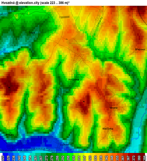
Below is the Elevation map of Hvozdná, which displays elevation range with different colors. Scale of the first map is from 223 to 386 m (732 to 1266 ft) with average elevation of 310.2 meters (=1018 ft) [note 1]
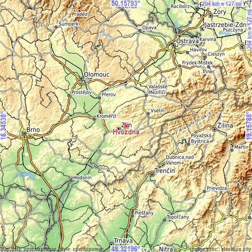
These maps also provides idea of topography and contour of this city, they are displayed at different zoom levels. More info about maps, scale and edge coordinates you can find below images.
| \ | Map #1 | Topo.Map |
| Scale [m] | 223..386 m | × |
| Scale [ft] | 732..1266 ft | × |
| Average | 310.2 m = 1018 ft | × |
| Width | 6.38 km = 4 mi | 204.1 km = 126.8 mi |
| Height | 6.38 km = 4 mi | 204.1 km = 126.8 mi |
| ↑Max Latitude | 49.277158° | 50.15793° |
| Latitude at center | 49.24848° | 49.24848° |
| ↓Min Latitude | 49.219785° | 48.32196° |
| ← Min Longitude | 17.707685° | 16.34538° |
| Longitude center | 17.75163° | 17.75163° |
| →Max Longitude | 17.795575° | 19.15788° |
Nearby cities:
Cities around Hvozdná sort by population:
• Zlín elevation 229 m
6.4 km,  247°
247°
• Vizovice 290 m
8 km,  110°
110°
• Fryšták 269 m
6.4 km,  309°
309°
• Slušovice 275 m
3.6 km,  91°
91°
• Lukov 310 m
4.9 km,  341°
341°
• Liptál 430 m
13.2 km,  69°
69°
• Tečovice 209 m
12.3 km,  255°
255°
• Újezd 437 m
14.3 km,  128°
128°
• Pozlovice 300 m
13.3 km,  174°
174°
• Březnice 296 m
9.4 km,  223°
223°
• Trnava 345 m
8.4 km,  51°
51°
• Všemina 385 m
9.8 km, 68°
Multilingual:
 En español:
Hvozdná elevación 287 m.
 En France:
Hvozdná élévation 287 m.


Sources and notes:
- [note 1] Map square and city borders are not equal. Map elevation data is calculated only from area inside that square.
- [src 1] Elevation data from geonames database provided with same terms of usage.
- [src 2] The elevation map of Hvozdná is generated using elevation data from NASA's 3 arcsec (90m) resolution SRTM data.
- [src 3] Base (background) map © OpenStreetMap contributors tiles are generated by Geofabrik and OpenTopoMap.
Copyright & License:
This Hvozdná Elevation Map is licensed under CC BY-SA. You may reuse any part from this page, if you give a proper credit by linking to this URL:
 More info on terms of use page.