Kojetín elevation
Kojetín (Olomoucký, Okres Přerov), Czech Republic elevation is 203 meters and Kojetín elevation in feet is 666 ft above sea level [src 1]. Kojetín is a populated place (feature code) with elevation that is 142 meters (466 ft) smaller than average city elevation in Czech Republic.
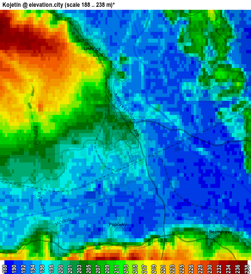
Below is the Elevation map of Kojetín, which displays elevation range with different colors. Scale of the first map is from 188 to 238 m (617 to 781 ft) with average elevation of 201.5 meters (=661 ft) [note 1]
These maps also provides idea of topography and contour of this city, they are displayed at different zoom levels. More info about maps, scale and edge coordinates you can find below images.
| \ | Map #1 | Map #2 | Topo.Map |
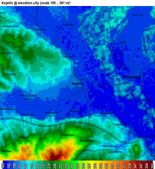
| Scale [m] | 188..238 m | 185..361 m | × |
| Scale [ft] | 617..781 ft | 607..1184 ft | × |
| Average | 201.5 m = 661 ft | 212.9 m = 698 ft | × |
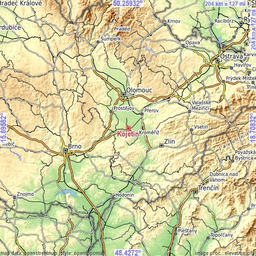
| Width | 6.37 km = 4 mi | 12.73 km = 7.9 mi | 203.7 km = 126.6 mi |
| Height | 6.37 km = 4 mi | 12.73 km = 7.9 mi | 203.7 km = 126.6 mi |
| ↑Max Latitude | 49.380408° | 49.40901° | 50.25932° |
| Latitude at center | 49.35179° | 49.35179° | 49.35179° |
| ↓Min Latitude | 49.323155° | 49.294504° | 48.4272° |
| ← Min Longitude | 17.258125° | 17.214179° | 15.89582° |
| Longitude center | 17.30207° | 17.30207° | 17.30207° |
| →Max Longitude | 17.346015° | 17.389961° | 18.70832° |
Nearby cities:
Cities around Kojetín sort by population:
• Kroměříž elevation 208 m
8.9 km,  132°
132°
• Hulín 191 m
12.3 km,  108°
108°
• Chropyně 197 m
4.6 km,  83°
83°
• Tovačov 203 m
8.8 km,  353°
353°
• Němčice nad Hanou 204 m
7 km,  260°
260°
• Zdounky 232 m
13.9 km,  174°
174°
• Troubky 199 m
9.6 km,  20°
20°
• Zborovice 252 m
11.5 km,  186°
186°
• Horní Moštěnice 206 m
13.2 km,  59°
59°
• Věrovany 203 m
12.2 km,  355°
355°
• Nezamyslice 207 m
9.8 km,  252°
252°
• Rataje 249 m
9.3 km,  164°
164°
Multilingual:
 En español:
Kojetín elevación 203 m.
 En France:
Kojetín élévation 203 m.


Sources and notes:
- [note 1] Map square and city borders are not equal. Map elevation data is calculated only from area inside that square.
- [src 1] Elevation data from geonames database provided with same terms of usage.
- [src 2] The elevation map of Kojetín is generated using elevation data from NASA's 3 arcsec (90m) resolution SRTM data.
- [src 3] Base (background) map © OpenStreetMap contributors tiles are generated by Geofabrik and OpenTopoMap.
Copyright & License:
This Kojetín Elevation Map is licensed under CC BY-SA. You may reuse any part from this page, if you give a proper credit by linking to this URL:
 More info on terms of use page.