Lanžhot elevation
Lanžhot (South Moravian, Okres Břeclav), Czech Republic elevation is 168 meters and Lanžhot elevation in feet is 551 ft above sea level [src 1]. Lanžhot is a populated place (feature code) with elevation that is 177 meters (581 ft) smaller than average city elevation in Czech Republic.
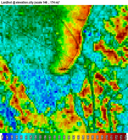
Below is the Elevation map of Lanžhot, which displays elevation range with different colors. Scale of the first map is from 146 to 174 m (479 to 571 ft) with average elevation of 157.1 meters (=515 ft) [note 1]
These maps also provides idea of topography and contour of this city, they are displayed at different zoom levels. More info about maps, scale and edge coordinates you can find below images.
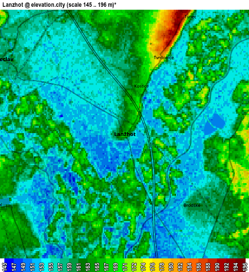
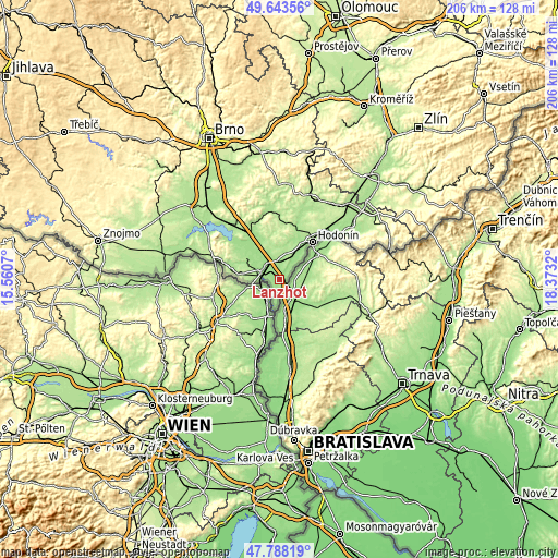
| \ | Map #1 | Map #2 | Topo.Map |
| Scale [m] | 146..174 m | 145..196 m | × |
| Scale [ft] | 479..571 ft | 476..643 ft | × |
| Average | 157.1 m = 515 ft | 158.7 m = 521 ft | × |
| Width | 6.45 km = 4 mi | 12.89 km = 8 mi | 206.3 km = 128.2 mi |
| Height | 6.45 km = 4 mi | 12.89 km = 8 mi | 206.3 km = 128.2 mi |
| ↑Max Latitude | 48.753412° | 48.782376° | 49.64356° |
| Latitude at center | 48.72443° | 48.72443° | 48.72443° |
| ↓Min Latitude | 48.695432° | 48.666417° | 47.78819° |
| ← Min Longitude | 16.923005° | 16.879059° | 15.5607° |
| Longitude center | 16.96695° | 16.96695° | 16.96695° |
| →Max Longitude | 17.010895° | 17.054841° | 18.3732° |
Nearby cities:
Cities around Lanžhot sort by population:
• Břeclav elevation 161 m
7.3 km,  301°
301°
• Velké Bílovice 178 m
14.9 km,  338°
338°
• Podivín 169 m
14.2 km,  322°
322°
• Moravská Nová Ves 190 m
9.4 km,  21°
21°
• Lednice 172 m
14.6 km, 304°
• Prušánky 183 m
11.6 km,  4°
4°
• Tvrdonice 181 m
4.5 km,  26°
26°
• Mikulčice 163 m
11.9 km, 31°
• Kostice 167 m
2.6 km, 19°
• Hrušky 172 m
7.6 km, 3°
• Moravský Žižkov 195 m
12.3 km,  347°
347°
• Týnec 167 m
7 km, 29°
Multilingual:
 En español:
Lanžhot elevación 168 m.
 En France:
Lanžhot élévation 168 m.


Sources and notes:
- [note 1] Map square and city borders are not equal. Map elevation data is calculated only from area inside that square.
- [src 1] Elevation data from geonames database provided with same terms of usage.
- [src 2] The elevation map of Lanžhot is generated using elevation data from NASA's 3 arcsec (90m) resolution SRTM data.
- [src 3] Base (background) map © OpenStreetMap contributors tiles are generated by Geofabrik and OpenTopoMap.
Copyright & License:
This Lanžhot Elevation Map is licensed under CC BY-SA. You may reuse any part from this page, if you give a proper credit by linking to this URL:
 More info on terms of use page.