Podivín elevation
Podivín (South Moravian, Okres Břeclav), Czech Republic elevation is 169 meters and Podivín elevation in feet is 554 ft above sea level [src 1]. Podivín is a populated place (feature code) with elevation that is 176 meters (577 ft) smaller than average city elevation in Czech Republic.
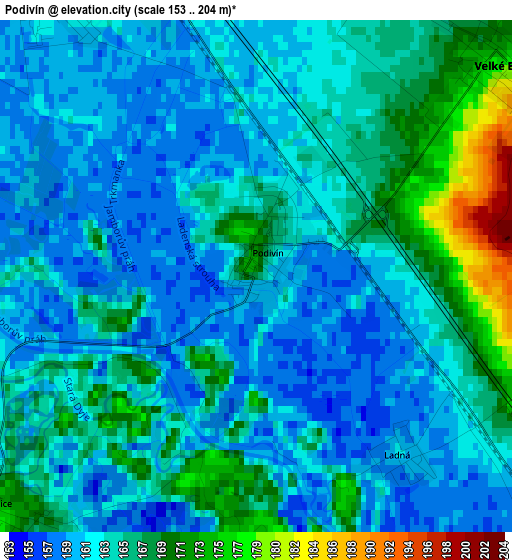
Below is the Elevation map of Podivín, which displays elevation range with different colors. Scale of the first map is from 153 to 204 m (502 to 669 ft) with average elevation of 163.2 meters (=535 ft) [note 1]
These maps also provides idea of topography and contour of this city, they are displayed at different zoom levels. More info about maps, scale and edge coordinates you can find below images.
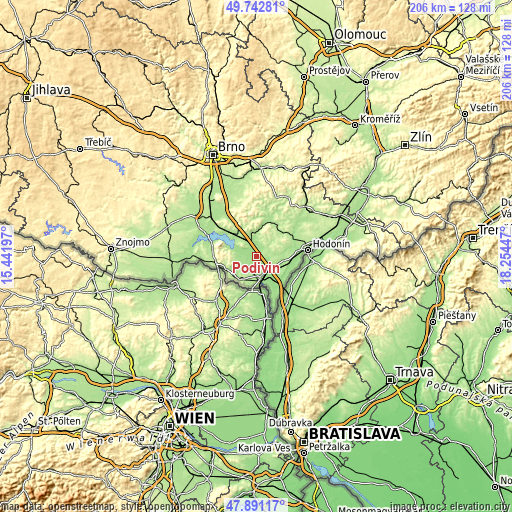
| \ | Map #1 | Topo.Map |
| Scale [m] | 153..204 m | × |
| Scale [ft] | 502..669 ft | × |
| Average | 163.2 m = 535 ft | × |
| Width | 6.43 km = 4 mi | 205.9 km = 127.9 mi |
| Height | 6.43 km = 4 mi | 205.9 km = 127.9 mi |
| ↑Max Latitude | 48.854463° | 49.74281° |
| Latitude at center | 48.82554° | 48.82554° |
| ↓Min Latitude | 48.7966° | 47.89117° |
| ← Min Longitude | 16.804275° | 15.44197° |
| Longitude center | 16.84822° | 16.84822° |
| →Max Longitude | 16.892165° | 18.25447° |
Nearby cities:
Cities around Podivín sort by population:
• Břeclav elevation 161 m
7.8 km,  161°
161°
• Velké Bílovice 178 m
4.2 km,  50°
50°
• Velké Pavlovice 182 m
9.1 km,  345°
345°
• Lednice 172 m
4.3 km,  229°
229°
• Prušánky 183 m
9.7 km,  88°
88°
• Rakvice 166 m
4.4 km,  324°
324°
• Zaječí 241 m
8 km,  311°
311°
• Hrušky 172 m
9.9 km,  111°
111°
• Moravský Žižkov 195 m
6.1 km,  82°
82°
• Hlohovec 177 m
8.5 km, 227°
• Bořetice 193 m
9.7 km,  2°
2°
• Vrbice 294 m
10.6 km,  20°
20°
Multilingual:
 En español:
Podivín elevación 169 m.
 En France:
Podivín élévation 169 m.


Sources and notes:
- [note 1] Map square and city borders are not equal. Map elevation data is calculated only from area inside that square.
- [src 1] Elevation data from geonames database provided with same terms of usage.
- [src 2] The elevation map of Podivín is generated using elevation data from NASA's 3 arcsec (90m) resolution SRTM data.
- [src 3] Base (background) map © OpenStreetMap contributors tiles are generated by Geofabrik and OpenTopoMap.
Copyright & License:
This Podivín Elevation Map is licensed under CC BY-SA. You may reuse any part from this page, if you give a proper credit by linking to this URL:
 More info on terms of use page.