Litoměřice elevation
Litoměřice (Ústecký kraj, Okres Litoměřice), Czech Republic elevation is 167 meters and Litoměřice elevation in feet is 548 ft above sea level [src 1]. Litoměřice is a populated place (feature code) with elevation that is 178 meters (584 ft) smaller than average city elevation in Czech Republic.
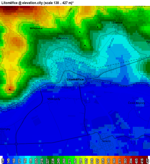
Below is the Elevation map of Litoměřice, which displays elevation range with different colors. Scale of the first map is from 138 to 427 m (453 to 1401 ft) with average elevation of 199.5 meters (=655 ft) [note 1]
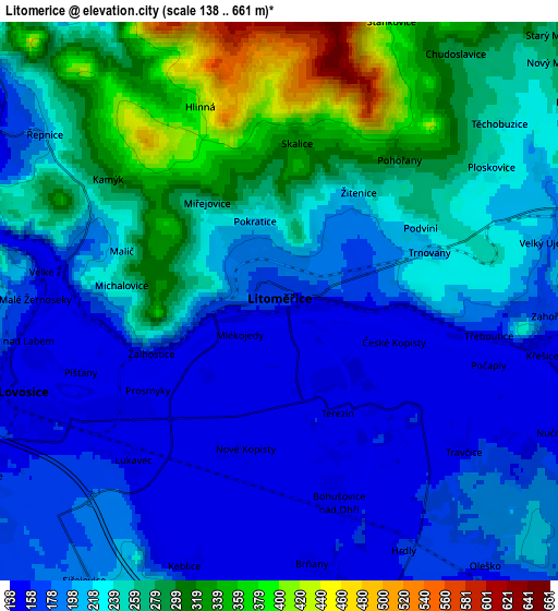
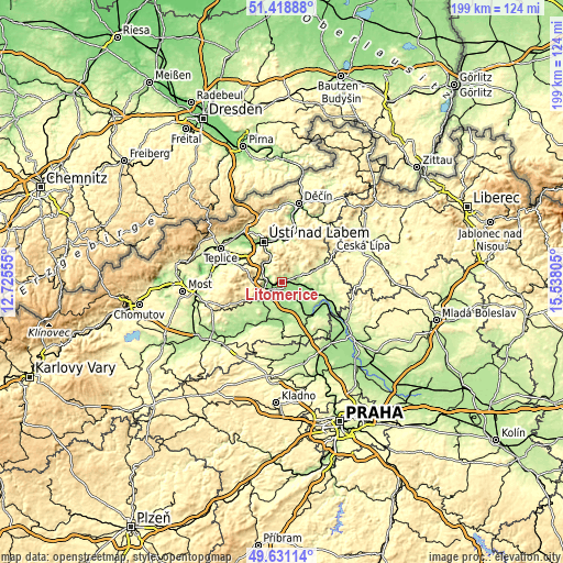
These maps also provides idea of topography and contour of this city, they are displayed at different zoom levels. More info about maps, scale and edge coordinates you can find below images.
| \ | Map #1 | Map #2 | Topo.Map |
| Scale [m] | 138..427 m | 138..661 m | × |
| Scale [ft] | 453..1401 ft | 453..2169 ft | × |
| Average | 199.5 m = 655 ft | 229.1 m = 752 ft | × |
| Width | 6.21 km = 3.9 mi | 12.42 km = 7.7 mi | 198.8 km = 123.5 mi |
| Height | 6.21 km = 3.9 mi | 12.42 km = 7.7 mi | 198.8 km = 123.5 mi |
| ↑Max Latitude | 50.561405° | 50.589313° | 51.41888° |
| Latitude at center | 50.53348° | 50.53348° | 50.53348° |
| ↓Min Latitude | 50.505539° | 50.477581° | 49.63114° |
| ← Min Longitude | 14.087855° | 14.043909° | 12.72555° |
| Longitude center | 14.1318° | 14.1318° | 14.1318° |
| →Max Longitude | 14.175745° | 14.219691° | 15.53805° |
Nearby cities:
Cities around Litoměřice sort by population:
• Lovosice elevation 156 m
6.1 km,  250°
250°
• Terezín 152 m
2.8 km,  152°
152°
• Bohušovice nad Ohří 153 m
4.7 km,  163°
163°
• Budyně nad Ohří 166 m
14.4 km,  181°
181°
• Velké Březno 148 m
14.4 km,  2°
2°
• Třebenice 228 m
11.9 km,  237°
237°
• Velemín 291 m
11 km,  273°
273°
• Žitenice 227 m
3 km,  35°
35°
• Liběšice 253 m
11.8 km,  70°
70°
• Křešice 150 m
6 km,  101°
101°
• Čížkovice 182 m
9.1 km,  233°
233°
• Polepy 160 m
9.9 km,  108°
108°
Multilingual:
 En español:
Litoměřice elevación 167 m.
 En France:
Litoměřice élévation 167 m.
 Auf Deutsch:
Leitmeritz höhe über dem Meeresspiegel ist 167 m.

Sources and notes:
- [note 1] Map square and city borders are not equal. Map elevation data is calculated only from area inside that square.
- [src 1] Elevation data from geonames database provided with same terms of usage.
- [src 2] The elevation map of Litoměřice is generated using elevation data from NASA's 3 arcsec (90m) resolution SRTM data.
- [src 3] Base (background) map © OpenStreetMap contributors tiles are generated by Geofabrik and OpenTopoMap.
Copyright & License:
This Litoměřice Elevation Map is licensed under CC BY-SA. You may reuse any part from this page, if you give a proper credit by linking to this URL:
 More info on terms of use page.