Velemín elevation
Velemín (Ústecký kraj, Okres Litoměřice), Czech Republic elevation is 291 meters and Velemín elevation in feet is 955 ft above sea level [src 1]. Velemín is a populated place (feature code) with elevation that is 54 meters (177 ft) smaller than average city elevation in Czech Republic.
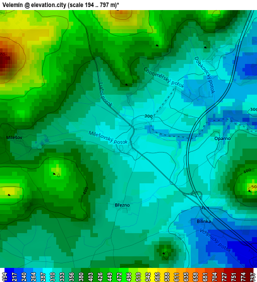
Below is the Elevation map of Velemín, which displays elevation range with different colors. Scale of the first map is from 194 to 797 m (636 to 2615 ft) with average elevation of 365.2 meters (=1198 ft) [note 1]
These maps also provides idea of topography and contour of this city, they are displayed at different zoom levels. More info about maps, scale and edge coordinates you can find below images.

| \ | Map #1 | Topo.Map |
| Scale [m] | 194..797 m | × |
| Scale [ft] | 636..2615 ft | × |
| Average | 365.2 m = 1198 ft | × |
| Width | 6.21 km = 3.9 mi | 198.8 km = 123.5 mi |
| Height | 6.21 km = 3.9 mi | 198.7 km = 123.5 mi |
| ↑Max Latitude | 50.566901° | 51.42428° |
| Latitude at center | 50.53898° | 50.53898° |
| ↓Min Latitude | 50.511042° | 49.63675° |
| ← Min Longitude | 13.932805° | 12.5705° |
| Longitude center | 13.97675° | 13.97675° |
| →Max Longitude | 14.020695° | 15.383° |
Nearby cities:
Cities around Velemín sort by population:
• Ústí nad Labem elevation 150 m
14.1 km,  16°
16°
• Litoměřice 167 m
11 km,  93°
93°
• Lovosice 156 m
5.9 km,  116°
116°
• Terezín 152 m
12.7 km,  104°
104°
• Trmice 150 m
11.6 km,  6°
6°
• Bohušovice nad Ohří 153 m
13.3 km,  112°
112°
• Bystřany 193 m
12.8 km,  321°
321°
• Třebenice 228 m
7 km,  172°
172°
• Žitenice 227 m
12.8 km,  81°
81°
• Čížkovice 182 m
7.1 km,  149°
149°
• Hostomice 192 m
13.1 km,  294°
294°
• Řehlovice 167 m
7.7 km,  348°
348°
Multilingual:
 En español:
Velemín elevación 291 m.
 En France:
Velemín élévation 291 m.


Sources and notes:
- [note 1] Map square and city borders are not equal. Map elevation data is calculated only from area inside that square.
- [src 1] Elevation data from geonames database provided with same terms of usage.
- [src 2] The elevation map of Velemín is generated using elevation data from NASA's 3 arcsec (90m) resolution SRTM data.
- [src 3] Base (background) map © OpenStreetMap contributors tiles are generated by Geofabrik and OpenTopoMap.
Copyright & License:
This Velemín Elevation Map is licensed under CC BY-SA. You may reuse any part from this page, if you give a proper credit by linking to this URL:
 More info on terms of use page.