Luhačovice elevation
Luhačovice (Zlín, Okres Zlín), Czech Republic elevation is 254 meters and Luhačovice elevation in feet is 833 ft above sea level [src 1]. Luhačovice is a populated place (feature code) with elevation that is 91 meters (299 ft) smaller than average city elevation in Czech Republic.
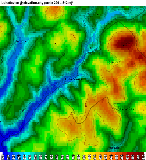
Below is the Elevation map of Luhačovice, which displays elevation range with different colors. Scale of the first map is from 226 to 512 m (741 to 1680 ft) with average elevation of 344.5 meters (=1130 ft) [note 1]
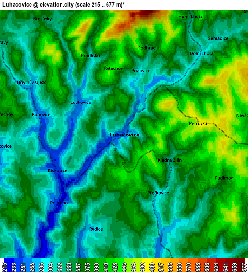
These maps also provides idea of topography and contour of this city, they are displayed at different zoom levels. More info about maps, scale and edge coordinates you can find below images.
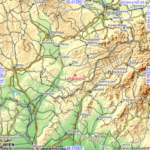
| \ | Map #1 | Map #2 | Topo.Map |
| Scale [m] | 226..512 m | 215..677 m | × |
| Scale [ft] | 741..1680 ft | 705..2221 ft | × |
| Average | 344.5 m = 1130 ft | 360.8 m = 1184 ft | × |
| Width | 6.4 km = 4 mi | 12.8 km = 8 mi | 204.8 km = 127.3 mi |
| Height | 6.4 km = 4 mi | 12.8 km = 8 mi | 204.7 km = 127.2 mi |
| ↑Max Latitude | 49.128585° | 49.157332° | 50.01203° |
| Latitude at center | 49.09982° | 49.09982° | 49.09982° |
| ↓Min Latitude | 49.071039° | 49.042241° | 48.17053° |
| ← Min Longitude | 17.713525° | 17.669579° | 16.35122° |
| Longitude center | 17.75747° | 17.75747° | 17.75747° |
| →Max Longitude | 17.801415° | 17.845361° | 19.16372° |
Nearby cities:
Cities around Luhačovice sort by population:
• Uherský Brod elevation 244 m
11.6 km,  224°
224°
• Slavičín 367 m
8.5 km,  98°
98°
• Bojkovice 278 m
8 km,  148°
148°
• Bánov 292 m
12.8 km,  193°
193°
• Šumice 226 m
8.3 km,  198°
198°
• Březolupy 205 m
13.1 km,  280°
280°
• Vlachovice 345 m
13.6 km,  78°
78°
• Újezd 437 m
13.2 km,  54°
54°
• Pozlovice 300 m
3.4 km,  14°
14°
• Březnice 296 m
11.8 km,  324°
324°
• Suchá Loz 297 m
14.8 km, 192°
• Záhorovice 249 m
8.7 km,  169°
169°
Multilingual:
 En español:
Luhačovice elevación 254 m.
 En France:
Luhačovice élévation 254 m.
 Auf Deutsch:
Luhačovice höhe über dem Meeresspiegel ist 254 m.

Sources and notes:
- [note 1] Map square and city borders are not equal. Map elevation data is calculated only from area inside that square.
- [src 1] Elevation data from geonames database provided with same terms of usage.
- [src 2] The elevation map of Luhačovice is generated using elevation data from NASA's 3 arcsec (90m) resolution SRTM data.
- [src 3] Base (background) map © OpenStreetMap contributors tiles are generated by Geofabrik and OpenTopoMap.
Copyright & License:
This Luhačovice Elevation Map is licensed under CC BY-SA. You may reuse any part from this page, if you give a proper credit by linking to this URL:
 More info on terms of use page.