Modřice elevation
Modřice (South Moravian, Okres Brno-venkov), Czech Republic elevation is 204 meters and Modřice elevation in feet is 669 ft above sea level [src 1]. Modřice is a populated place (feature code) with elevation that is 141 meters (463 ft) smaller than average city elevation in Czech Republic.
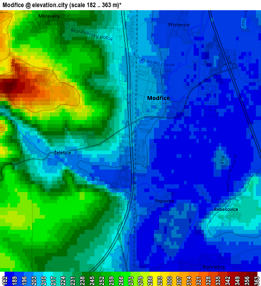
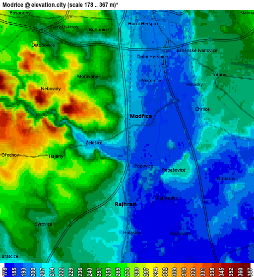
Below is the Elevation map of Modřice, which displays elevation range with different colors. Scale of the first map is from 182 to 363 m (597 to 1191 ft) with average elevation of 220.7 meters (=724 ft) [note 1]
These maps also provides idea of topography and contour of this city, they are displayed at different zoom levels. More info about maps, scale and edge coordinates you can find below images.
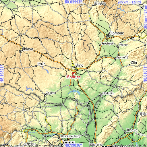
| \ | Map #1 | Map #2 | Topo.Map |
| Scale [m] | 182..363 m | 178..367 m | × |
| Scale [ft] | 597..1191 ft | 584..1204 ft | × |
| Average | 220.7 m = 724 ft | 228.1 m = 748 ft | × |
| Width | 6.4 km = 4 mi | 12.79 km = 7.9 mi | 204.7 km = 127.2 mi |
| Height | 6.4 km = 4 mi | 12.79 km = 7.9 mi | 204.7 km = 127.2 mi |
| ↑Max Latitude | 49.148033° | 49.17677° | 50.03113° |
| Latitude at center | 49.11928° | 49.11928° | 49.11928° |
| ↓Min Latitude | 49.09051° | 49.061723° | 48.19036° |
| ← Min Longitude | 16.560515° | 16.516569° | 15.19821° |
| Longitude center | 16.60446° | 16.60446° | 16.60446° |
| →Max Longitude | 16.648405° | 16.692351° | 18.01071° |
Nearby cities:
Cities around Modřice sort by population:
• Brno elevation 226 m
8.4 km,  1°
1°
• Rajhrad 196 m
3.2 km,  180°
180°
• Střelice 273 m
8.2 km,  296°
296°
• Ořechov 296 m
6 km,  261°
261°
• Blučina 189 m
7.7 km,  157°
157°
• Sokolnice 203 m
8.5 km,  94°
94°
• Měnín 191 m
7.7 km,  122°
122°
• Ostopovice 238 m
6.3 km,  317°
317°
• Moravany 248 m
3.6 km,  330°
330°
• Želešice 206 m
1.7 km, 261°
• Rajhradice 185 m
3.5 km,  149°
149°
• Vojkovice 184 m
7.6 km, 177°
Multilingual:
 En español:
Modřice elevación 204 m.
 En France:
Modřice élévation 204 m.


Sources and notes:
- [note 1] Map square and city borders are not equal. Map elevation data is calculated only from area inside that square.
- [src 1] Elevation data from geonames database provided with same terms of usage.
- [src 2] The elevation map of Modřice is generated using elevation data from NASA's 3 arcsec (90m) resolution SRTM data.
- [src 3] Base (background) map © OpenStreetMap contributors tiles are generated by Geofabrik and OpenTopoMap.
Copyright & License:
This Modřice Elevation Map is licensed under CC BY-SA. You may reuse any part from this page, if you give a proper credit by linking to this URL:
 More info on terms of use page.