Mohelno elevation
Mohelno (Vysočina, Okres Třebíč), Czech Republic elevation is 348 meters and Mohelno elevation in feet is 1142 ft above sea level [src 1]. Mohelno is a populated place (feature code) with elevation that is 3 meters (10 ft) bigger than average city elevation in Czech Republic.
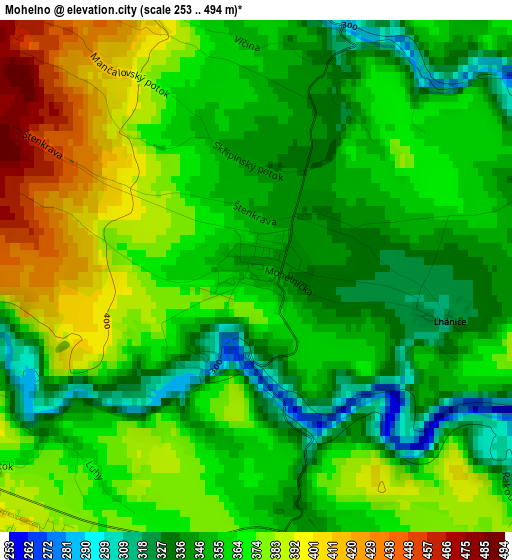
Below is the Elevation map of Mohelno, which displays elevation range with different colors. Scale of the first map is from 253 to 494 m (830 to 1621 ft) with average elevation of 362.6 meters (=1190 ft) [note 1]
These maps also provides idea of topography and contour of this city, they are displayed at different zoom levels. More info about maps, scale and edge coordinates you can find below images.
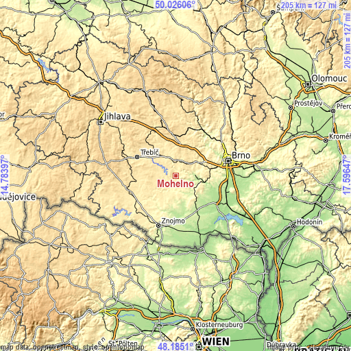
| \ | Map #1 | Topo.Map |
| Scale [m] | 253..494 m | × |
| Scale [ft] | 830..1621 ft | × |
| Average | 362.6 m = 1190 ft | × |
| Width | 6.4 km = 4 mi | 204.7 km = 127.2 mi |
| Height | 6.4 km = 4 mi | 204.7 km = 127.2 mi |
| ↑Max Latitude | 49.142876° | 50.02606° |
| Latitude at center | 49.11412° | 49.11412° |
| ↓Min Latitude | 49.085347° | 48.1851° |
| ← Min Longitude | 16.146275° | 14.78397° |
| Longitude center | 16.19022° | 16.19022° |
| →Max Longitude | 16.234165° | 17.59647° |
Nearby cities:
Cities around Mohelno sort by population:
• Ivančice elevation 212 m
13.7 km,  95°
95°
• Moravský Krumlov 258 m
11.4 km,  129°
129°
• Rosice 339 m
16.3 km,  62°
62°
• Náměšť nad Oslavou 429 m
10.6 km,  347°
347°
• Oslavany 218 m
10.7 km,  84°
84°
• Zbýšov 351 m
12.5 km,  68°
68°
• Zastávka 319 m
15 km, 56°
• Hrotovice 411 m
9.5 km,  265°
265°
• Vladislav 388 m
18.2 km,  306°
306°
• Zbraslav 464 m
14.1 km,  32°
32°
• Višňové 338 m
14.9 km,  191°
191°
• Rouchovany 352 m
7.7 km,  231°
231°
Multilingual:
 En español:
Mohelno elevación 348 m.
 En France:
Mohelno élévation 348 m.


Sources and notes:
- [note 1] Map square and city borders are not equal. Map elevation data is calculated only from area inside that square.
- [src 1] Elevation data from geonames database provided with same terms of usage.
- [src 2] The elevation map of Mohelno is generated using elevation data from NASA's 3 arcsec (90m) resolution SRTM data.
- [src 3] Base (background) map © OpenStreetMap contributors tiles are generated by Geofabrik and OpenTopoMap.
Copyright & License:
This Mohelno Elevation Map is licensed under CC BY-SA. You may reuse any part from this page, if you give a proper credit by linking to this URL:
 More info on terms of use page.