Mutěnice elevation
Mutěnice (South Moravian, Okres Hodonín), Czech Republic elevation is 182 meters and Mutěnice elevation in feet is 597 ft above sea level [src 1]. Mutěnice is a populated place (feature code) with elevation that is 163 meters (535 ft) smaller than average city elevation in Czech Republic.
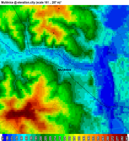
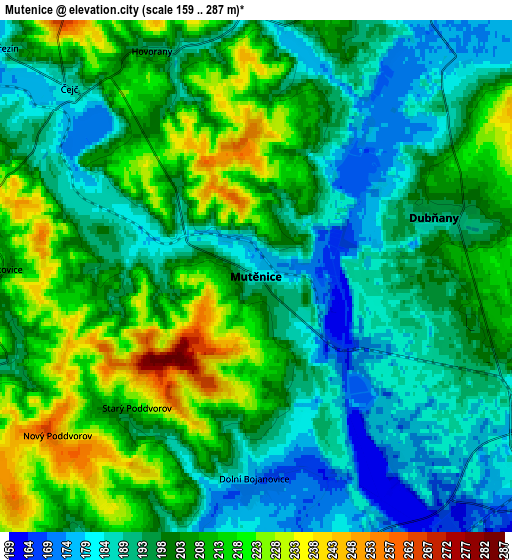
Below is the Elevation map of Mutěnice, which displays elevation range with different colors. Scale of the first map is from 161 to 287 m (528 to 942 ft) with average elevation of 204.5 meters (=671 ft) [note 1]
These maps also provides idea of topography and contour of this city, they are displayed at different zoom levels. More info about maps, scale and edge coordinates you can find below images.
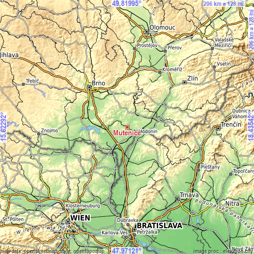
| \ | Map #1 | Map #2 | Topo.Map |
| Scale [m] | 161..287 m | 159..287 m | × |
| Scale [ft] | 528..942 ft | 522..942 ft | × |
| Average | 204.5 m = 671 ft | 200.6 m = 658 ft | × |
| Width | 6.42 km = 4 mi | 12.85 km = 8 mi | 205.6 km = 127.8 mi |
| Height | 6.42 km = 4 mi | 12.85 km = 8 mi | 205.5 km = 127.7 mi |
| ↑Max Latitude | 48.933008° | 48.961869° | 49.81995° |
| Latitude at center | 48.90413° | 48.90413° | 48.90413° |
| ↓Min Latitude | 48.875235° | 48.846324° | 47.97121° |
| ← Min Longitude | 16.985225° | 16.941279° | 15.62292° |
| Longitude center | 17.02917° | 17.02917° | 17.02917° |
| →Max Longitude | 17.073115° | 17.117061° | 18.43542° |
Nearby cities:
Cities around Mutěnice sort by population:
• Hodonín elevation 163 m
9.7 km,  129°
129°
• Dubňany 191 m
4.7 km,  72°
72°
• Dolní Bojanovice 174 m
5.1 km,  180°
180°
• Lužice 174 m
7.7 km,  156°
156°
• Čejkovice 209 m
6.4 km,  271°
271°
• Hovorany 193 m
6.2 km,  335°
335°
• Šardice 183 m
6.7 km,  359°
359°
• Prušánky 183 m
9.1 km,  202°
202°
• Milotice 183 m
10 km,  55°
55°
• Mikulčice 163 m
9.9 km,  170°
170°
• Čejč 185 m
6.6 km,  315°
315°
• Vrbice 294 m
9.7 km,  277°
277°
Multilingual:
 En español:
Mutěnice elevación 182 m.
 En France:
Mutěnice élévation 182 m.
 Auf Deutsch:
Mutěnice höhe über dem Meeresspiegel ist 182 m.

Sources and notes:
- [note 1] Map square and city borders are not equal. Map elevation data is calculated only from area inside that square.
- [src 1] Elevation data from geonames database provided with same terms of usage.
- [src 2] The elevation map of Mutěnice is generated using elevation data from NASA's 3 arcsec (90m) resolution SRTM data.
- [src 3] Base (background) map © OpenStreetMap contributors tiles are generated by Geofabrik and OpenTopoMap.
Copyright & License:
This Mutěnice Elevation Map is licensed under CC BY-SA. You may reuse any part from this page, if you give a proper credit by linking to this URL:
 More info on terms of use page.