Podolí elevation
Podolí (South Moravian, Okres Brno-venkov), Czech Republic elevation is 243 meters and Podolí elevation in feet is 797 ft above sea level [src 1]. Podolí is a populated place (feature code) with elevation that is 102 meters (335 ft) smaller than average city elevation in Czech Republic.
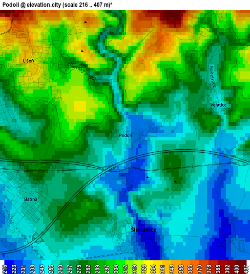
Below is the Elevation map of Podolí, which displays elevation range with different colors. Scale of the first map is from 216 to 407 m (709 to 1335 ft) with average elevation of 277.7 meters (=911 ft) [note 1]
These maps also provides idea of topography and contour of this city, they are displayed at different zoom levels. More info about maps, scale and edge coordinates you can find below images.
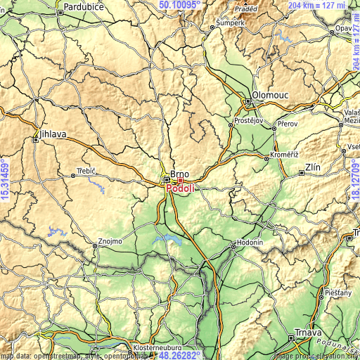
| \ | Map #1 | Topo.Map |
| Scale [m] | 216..407 m | × |
| Scale [ft] | 709..1335 ft | × |
| Average | 277.7 m = 911 ft | × |
| Width | 6.39 km = 4 mi | 204.4 km = 127 mi |
| Height | 6.39 km = 4 mi | 204.4 km = 127 mi |
| ↑Max Latitude | 49.219132° | 50.10095° |
| Latitude at center | 49.19042° | 49.19042° |
| ↓Min Latitude | 49.161691° | 48.26282° |
| ← Min Longitude | 16.676895° | 15.31459° |
| Longitude center | 16.72084° | 16.72084° |
| →Max Longitude | 16.764785° | 18.12709° |
Nearby cities:
Cities around Podolí sort by population:
• Brno elevation 226 m
8.2 km,  273°
273°
• Šlapanice 221 m
2.5 km,  169°
169°
• Modřice 204 m
11.6 km,  226°
226°
• Bílovice nad Svitavou 225 m
7.2 km,  330°
330°
• Pozořice 316 m
5.5 km,  67°
67°
• Sokolnice 203 m
8.5 km,  179°
179°
• Křenovice 204 m
9.5 km,  124°
124°
• Telnice 196 m
9.8 km, 181°
• Moravany 248 m
11.3 km,  245°
245°
• Tvarožná 255 m
3.7 km,  87°
87°
• Blažovice 238 m
5.5 km, 120°
• Viničné Šumice 293 m
8 km, 71°
Multilingual:
 En español:
Podolí elevación 243 m.
 En France:
Podolí élévation 243 m.
 Auf Deutsch:
Kritschen höhe über dem Meeresspiegel ist 243 m.

Sources and notes:
- [note 1] Map square and city borders are not equal. Map elevation data is calculated only from area inside that square.
- [src 1] Elevation data from geonames database provided with same terms of usage.
- [src 2] The elevation map of Podolí is generated using elevation data from NASA's 3 arcsec (90m) resolution SRTM data.
- [src 3] Base (background) map © OpenStreetMap contributors tiles are generated by Geofabrik and OpenTopoMap.
Copyright & License:
This Podolí Elevation Map is licensed under CC BY-SA. You may reuse any part from this page, if you give a proper credit by linking to this URL:
 More info on terms of use page.