Pražmo elevation
Pražmo (Moravskoslezský, Okres Frýdek-Místek), Czech Republic elevation is 435 meters and Pražmo elevation in feet is 1427 ft above sea level [src 1]. Pražmo is a populated place (feature code) with elevation that is 90 meters (295 ft) bigger than average city elevation in Czech Republic.
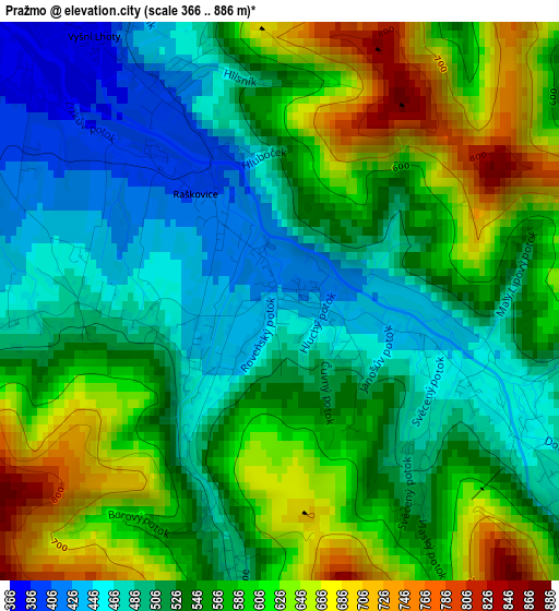
Below is the Elevation map of Pražmo, which displays elevation range with different colors. Scale of the first map is from 366 to 886 m (1201 to 2907 ft) with average elevation of 552.9 meters (=1814 ft) [note 1]
These maps also provides idea of topography and contour of this city, they are displayed at different zoom levels. More info about maps, scale and edge coordinates you can find below images.
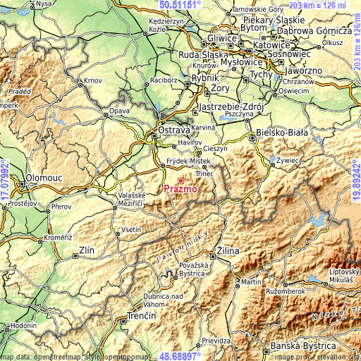
| \ | Map #1 | Topo.Map |
| Scale [m] | 366..886 m | × |
| Scale [ft] | 1201..2907 ft | × |
| Average | 552.9 m = 1814 ft | × |
| Width | 6.33 km = 3.9 mi | 202.6 km = 125.9 mi |
| Height | 6.33 km = 3.9 mi | 202.6 km = 125.9 mi |
| ↑Max Latitude | 49.637228° | 50.51151° |
| Latitude at center | 49.60876° | 49.60876° |
| ↓Min Latitude | 49.580275° | 48.68897° |
| ← Min Longitude | 18.442225° | 17.07992° |
| Longitude center | 18.48617° | 18.48617° |
| →Max Longitude | 18.530115° | 19.89242° |
Nearby cities:
Cities around Pražmo sort by population:
• Frýdlant nad Ostravicí elevation 355 m
9.3 km,  258°
258°
• Baška 312 m
9.2 km,  296°
296°
• Dobrá 331 m
8.9 km,  324°
324°
• Ostravice 436 m
10.7 km,  219°
219°
• Raškovice 405 m
1.6 km, 321°
• Janovice 362 m
5.9 km,  283°
283°
• Metylovice 370 m
10.6 km,  268°
268°
• Hnojník 374 m
9.1 km,  25°
25°
• Staré Město 300 m
11.1 km,  307°
307°
• Komorní Lhotka 413 m
6.3 km, 28°
• Dobratice 397 m
5.8 km,  4°
4°
• Morávka 462 m
3.1 km,  116°
116°
Multilingual:
 En español:
Pražmo elevación 435 m.
 En France:
Pražmo élévation 435 m.


Sources and notes:
- [note 1] Map square and city borders are not equal. Map elevation data is calculated only from area inside that square.
- [src 1] Elevation data from geonames database provided with same terms of usage.
- [src 2] The elevation map of Pražmo is generated using elevation data from NASA's 3 arcsec (90m) resolution SRTM data.
- [src 3] Base (background) map © OpenStreetMap contributors tiles are generated by Geofabrik and OpenTopoMap.
Copyright & License:
This Pražmo Elevation Map is licensed under CC BY-SA. You may reuse any part from this page, if you give a proper credit by linking to this URL:
 More info on terms of use page.