Prostějov elevation
Prostějov (Olomoucký, Okres Prostějov), Czech Republic elevation is 227 meters and Prostějov elevation in feet is 745 ft above sea level [src 1]. Prostějov is a populated place (feature code) with elevation that is 118 meters (387 ft) smaller than average city elevation in Czech Republic.
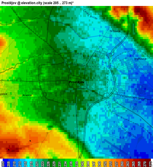
Below is the Elevation map of Prostějov, which displays elevation range with different colors. Scale of the first map is from 205 to 273 m (673 to 896 ft) with average elevation of 228.4 meters (=749 ft) [note 1]
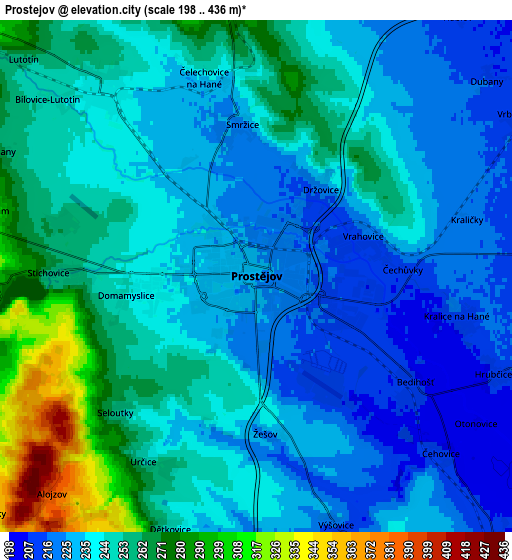
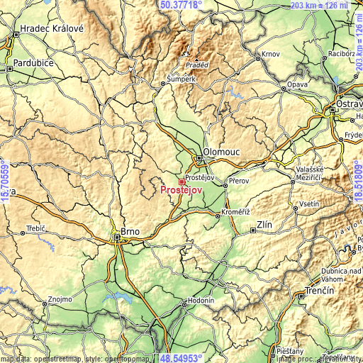
These maps also provides idea of topography and contour of this city, they are displayed at different zoom levels. More info about maps, scale and edge coordinates you can find below images.
| \ | Map #1 | Map #2 | Topo.Map |
| Scale [m] | 205..273 m | 198..436 m | × |
| Scale [ft] | 673..896 ft | 650..1430 ft | × |
| Average | 228.4 m = 749 ft | 244 m = 801 ft | × |
| Width | 6.35 km = 3.9 mi | 12.7 km = 7.9 mi | 203.2 km = 126.3 mi |
| Height | 6.35 km = 3.9 mi | 12.7 km = 7.9 mi | 203.2 km = 126.3 mi |
| ↑Max Latitude | 49.500428° | 49.52896° | 50.37718° |
| Latitude at center | 49.47188° | 49.47188° | 49.47188° |
| ↓Min Latitude | 49.443315° | 49.414734° | 48.54953° |
| ← Min Longitude | 17.067895° | 17.023949° | 15.70559° |
| Longitude center | 17.11184° | 17.11184° | 17.11184° |
| →Max Longitude | 17.155785° | 17.199731° | 18.51809° |
Nearby cities:
Cities around Prostějov sort by population:
• Lutín elevation 222 m
9.8 km,  10°
10°
• Kostelec na Hané 241 m
6.1 km,  320°
320°
• Plumlov 307 m
7 km,  264°
264°
• Smržice 223 m
3.8 km,  354°
354°
• Vrbátky 211 m
7.5 km,  57°
57°
• Slatinice 233 m
10 km,  355°
355°
• Kralice na Hané 213 m
5.1 km,  101°
101°
• Mostkovice 254 m
4.3 km,  270°
270°
• Určice 255 m
5.4 km,  211°
211°
• Otaslavice 252 m
9.7 km,  197°
197°
• Čelechovice na Hané 239 m
5.1 km, 345°
• Bedihošť 208 m
4.7 km,  123°
123°
Multilingual:
 En español:
Prostějov elevación 227 m.
 En France:
Prostějov élévation 227 m.
 Auf Deutsch:
Prossnitz höhe über dem Meeresspiegel ist 227 m.
 На русском:
Простейов, Простеёв высота над уровнем моря 227 м
Sources and notes:
- [note 1] Map square and city borders are not equal. Map elevation data is calculated only from area inside that square.
- [src 1] Elevation data from geonames database provided with same terms of usage.
- [src 2] The elevation map of Prostějov is generated using elevation data from NASA's 3 arcsec (90m) resolution SRTM data.
- [src 3] Base (background) map © OpenStreetMap contributors tiles are generated by Geofabrik and OpenTopoMap.
Copyright & License:
This Prostějov Elevation Map is licensed under CC BY-SA. You may reuse any part from this page, if you give a proper credit by linking to this URL:
 More info on terms of use page.