Říčany elevation
Říčany (Central Bohemia, Okres Praha-východ), Czech Republic elevation is 343 meters and Říčany elevation in feet is 1125 ft above sea level [src 1]. Říčany is a populated place (feature code) with elevation that is 2 meters (7 ft) smaller than average city elevation in Czech Republic.
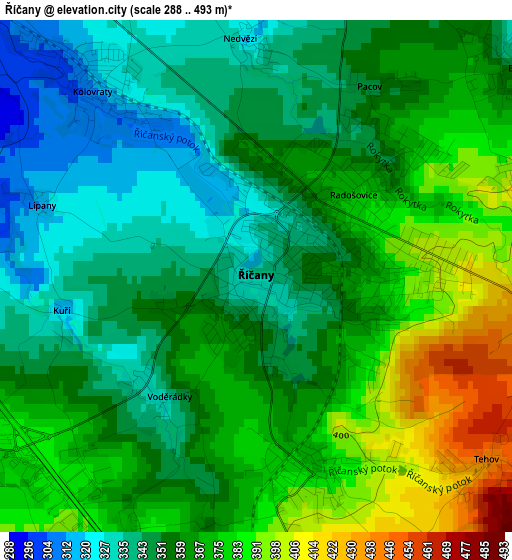
Below is the Elevation map of Říčany, which displays elevation range with different colors. Scale of the first map is from 288 to 493 m (945 to 1617 ft) with average elevation of 361.2 meters (=1185 ft) [note 1]
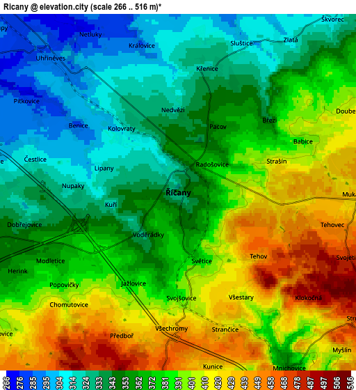
These maps also provides idea of topography and contour of this city, they are displayed at different zoom levels. More info about maps, scale and edge coordinates you can find below images.
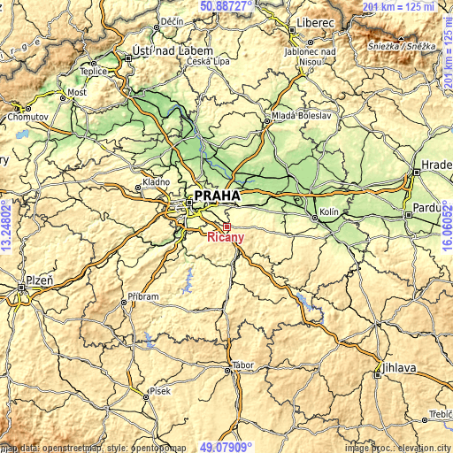
| \ | Map #1 | Map #2 | Topo.Map |
| Scale [m] | 288..493 m | 266..516 m | × |
| Scale [ft] | 945..1617 ft | 873..1693 ft | × |
| Average | 361.2 m = 1185 ft | 372.2 m = 1221 ft | × |
| Width | 6.28 km = 3.9 mi | 12.57 km = 7.8 mi | 201.1 km = 125 mi |
| Height | 6.28 km = 3.9 mi | 12.57 km = 7.8 mi | 201 km = 124.9 mi |
| ↑Max Latitude | 50.019924° | 50.048152° | 50.88727° |
| Latitude at center | 49.99168° | 49.99168° | 49.99168° |
| ↓Min Latitude | 49.963419° | 49.935142° | 49.07909° |
| ← Min Longitude | 14.610325° | 14.566379° | 13.24802° |
| Longitude center | 14.65427° | 14.65427° | 14.65427° |
| →Max Longitude | 14.698215° | 14.742161° | 16.06052° |
Nearby cities:
Cities around Říčany sort by population:
• Úvaly elevation 249 m
10.7 km,  30°
30°
• Jesenice 351 m
10.4 km,  255°
255°
• Kamenice 381 m
11.3 km,  207°
207°
• Mnichovice 351 m
7.3 km,  147°
147°
• Psáry 323 m
11.9 km,  238°
238°
• Dolní Počernice 234 m
12.2 km,  331°
331°
• Průhonice 296 m
7.5 km,  276°
276°
• Velké Popovice 419 m
7.8 km,  187°
187°
• Strančice 419 m
5.1 km,  161°
161°
• Mukařov 432 m
6.2 km,  90°
90°
• Pyšely 372 m
12.9 km,  172°
172°
• Vestec 331 m
10.8 km, 263°
Multilingual:
 En español:
Říčany elevación 343 m.
 En France:
Říčany élévation 343 m.


Sources and notes:
- [note 1] Map square and city borders are not equal. Map elevation data is calculated only from area inside that square.
- [src 1] Elevation data from geonames database provided with same terms of usage.
- [src 2] The elevation map of Říčany is generated using elevation data from NASA's 3 arcsec (90m) resolution SRTM data.
- [src 3] Base (background) map © OpenStreetMap contributors tiles are generated by Geofabrik and OpenTopoMap.
Copyright & License:
This Říčany Elevation Map is licensed under CC BY-SA. You may reuse any part from this page, if you give a proper credit by linking to this URL:
 More info on terms of use page.