Slatiňany elevation
Slatiňany (Pardubický, Okres Chrudim), Czech Republic elevation is 267 meters and Slatiňany elevation in feet is 876 ft above sea level [src 1]. Slatiňany is a populated place (feature code) with elevation that is 78 meters (256 ft) smaller than average city elevation in Czech Republic.
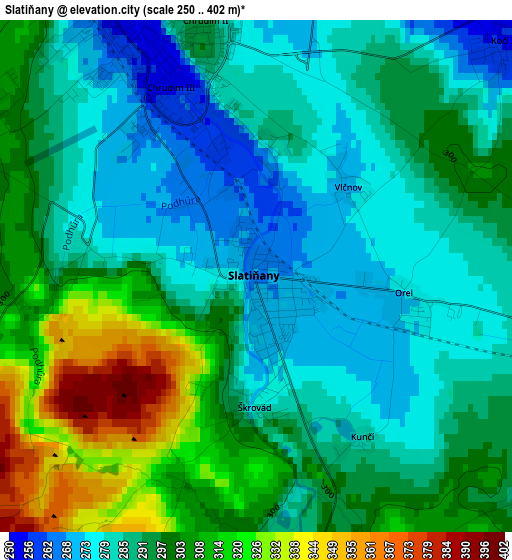
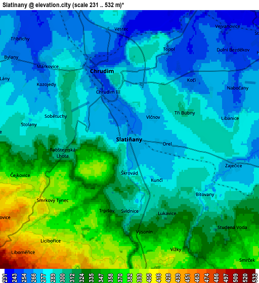
Below is the Elevation map of Slatiňany, which displays elevation range with different colors. Scale of the first map is from 250 to 402 m (820 to 1319 ft) with average elevation of 294.2 meters (=965 ft) [note 1]
These maps also provides idea of topography and contour of this city, they are displayed at different zoom levels. More info about maps, scale and edge coordinates you can find below images.
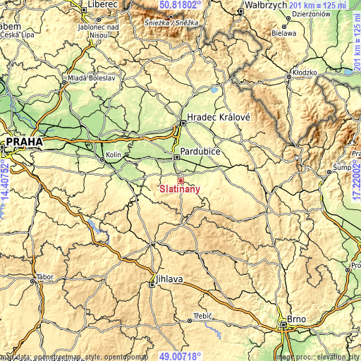
| \ | Map #1 | Map #2 | Topo.Map |
| Scale [m] | 250..402 m | 231..532 m | × |
| Scale [ft] | 820..1319 ft | 758..1745 ft | × |
| Average | 294.2 m = 965 ft | 307.3 m = 1008 ft | × |
| Width | 6.29 km = 3.9 mi | 12.58 km = 7.8 mi | 201.3 km = 125.1 mi |
| Height | 6.29 km = 3.9 mi | 12.58 km = 7.8 mi | 201.3 km = 125.1 mi |
| ↑Max Latitude | 49.949386° | 49.977654° | 50.81802° |
| Latitude at center | 49.9211° | 49.9211° | 49.9211° |
| ↓Min Latitude | 49.892798° | 49.864479° | 49.00718° |
| ← Min Longitude | 15.769825° | 15.725879° | 14.40752° |
| Longitude center | 15.81377° | 15.81377° | 15.81377° |
| →Max Longitude | 15.857715° | 15.901661° | 17.22002° |
Nearby cities:
Cities around Slatiňany sort by population:
• Pardubice elevation 227 m
13.6 km,  348°
348°
• Chrudim 274 m
3.6 km,  338°
338°
• Heřmanův Městec 281 m
11 km,  285°
285°
• Chrast 288 m
8.9 km,  103°
103°
• Hrochův Týnec 243 m
8.1 km,  58°
58°
• Dašice 229 m
13.9 km,  30°
30°
• Moravany 248 m
12.7 km,  45°
45°
• Nasavrky 487 m
8.5 km,  184°
184°
• Prachovice 456 m
13.6 km,  257°
257°
• Rosice 261 m
9.8 km,  89°
89°
• Chroustovice 258 m
13.3 km,  73°
73°
• Miřetice 394 m
10.2 km,  150°
150°
Multilingual:
 En español:
Slatiňany elevación 267 m.
 En France:
Slatiňany élévation 267 m.
 Auf Deutsch:
Slatiňany höhe über dem Meeresspiegel ist 267 m.

Sources and notes:
- [note 1] Map square and city borders are not equal. Map elevation data is calculated only from area inside that square.
- [src 1] Elevation data from geonames database provided with same terms of usage.
- [src 2] The elevation map of Slatiňany is generated using elevation data from NASA's 3 arcsec (90m) resolution SRTM data.
- [src 3] Base (background) map © OpenStreetMap contributors tiles are generated by Geofabrik and OpenTopoMap.
Copyright & License:
This Slatiňany Elevation Map is licensed under CC BY-SA. You may reuse any part from this page, if you give a proper credit by linking to this URL:
 More info on terms of use page.