Sobotka elevation
Sobotka (Královéhradecký kraj, Okres Jičín), Czech Republic elevation is 303 meters and Sobotka elevation in feet is 994 ft above sea level [src 1]. Sobotka is a populated place (feature code) with elevation that is 42 meters (138 ft) smaller than average city elevation in Czech Republic.
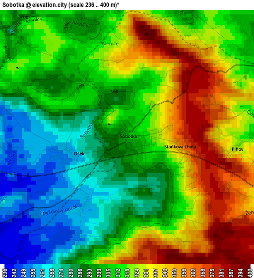
Below is the Elevation map of Sobotka, which displays elevation range with different colors. Scale of the first map is from 236 to 400 m (774 to 1312 ft) with average elevation of 311.9 meters (=1023 ft) [note 1]
These maps also provides idea of topography and contour of this city, they are displayed at different zoom levels. More info about maps, scale and edge coordinates you can find below images.
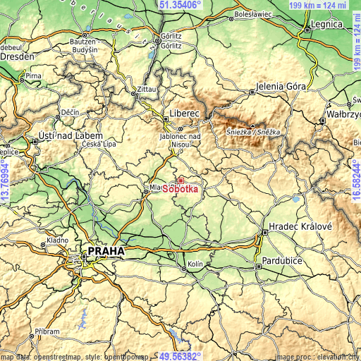
| \ | Map #1 | Topo.Map |
| Scale [m] | 236..400 m | × |
| Scale [ft] | 774..1312 ft | × |
| Average | 311.9 m = 1023 ft | × |
| Width | 6.22 km = 3.9 mi | 199.1 km = 123.7 mi |
| Height | 6.22 km = 3.9 mi | 199 km = 123.7 mi |
| ↑Max Latitude | 50.495374° | 51.35406° |
| Latitude at center | 50.46741° | 50.46741° |
| ↓Min Latitude | 50.43943° | 49.56382° |
| ← Min Longitude | 15.132245° | 13.76994° |
| Longitude center | 15.17619° | 15.17619° |
| →Max Longitude | 15.220135° | 16.58244° |
Nearby cities:
Cities around Sobotka sort by population:
• Jičín elevation 288 m
12.9 km,  105°
105°
• Turnov 255 m
13 km,  352°
352°
• Lomnice nad Popelkou 479 m
15.6 km,  63°
63°
• Dolní Bousov 243 m
4.7 km,  226°
226°
• Libáň 242 m
10.6 km,  164°
164°
• Valdice 311 m
14.8 km,  95°
95°
• Kněžmost 244 m
10.1 km,  283°
283°
• Příšovice 241 m
13.9 km,  332°
332°
• Rovensko pod Troskami 304 m
9.6 km,  37°
37°
• Žďár 239 m
10.9 km,  321°
321°
• Železnice 322 m
14.8 km,  87°
87°
• Ohrazenice 288 m
14.9 km, 346°
Multilingual:
 En español:
Sobotka elevación 303 m.
 En France:
Sobotka élévation 303 m.


Sources and notes:
- [note 1] Map square and city borders are not equal. Map elevation data is calculated only from area inside that square.
- [src 1] Elevation data from geonames database provided with same terms of usage.
- [src 2] The elevation map of Sobotka is generated using elevation data from NASA's 3 arcsec (90m) resolution SRTM data.
- [src 3] Base (background) map © OpenStreetMap contributors tiles are generated by Geofabrik and OpenTopoMap.
Copyright & License:
This Sobotka Elevation Map is licensed under CC BY-SA. You may reuse any part from this page, if you give a proper credit by linking to this URL:
 More info on terms of use page.