Štíty elevation
Štíty (Olomoucký, Okres Šumperk), Czech Republic elevation is 442 meters and Štíty elevation in feet is 1450 ft above sea level [src 1]. Štíty is a populated place (feature code) with elevation that is 97 meters (318 ft) bigger than average city elevation in Czech Republic.
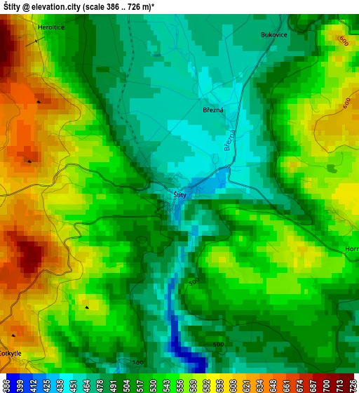
Below is the Elevation map of Štíty, which displays elevation range with different colors. Scale of the first map is from 386 to 726 m (1266 to 2382 ft) with average elevation of 528.5 meters (=1734 ft) [note 1]
These maps also provides idea of topography and contour of this city, they are displayed at different zoom levels. More info about maps, scale and edge coordinates you can find below images.
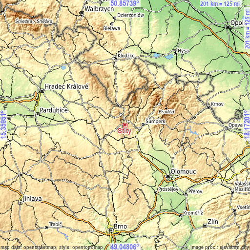
| \ | Map #1 | Topo.Map |
| Scale [m] | 386..726 m | × |
| Scale [ft] | 1266..2382 ft | × |
| Average | 528.5 m = 1734 ft | × |
| Width | 6.29 km = 3.9 mi | 201.2 km = 125 mi |
| Height | 6.29 km = 3.9 mi | 201.2 km = 125 mi |
| ↑Max Latitude | 49.989482° | 50.85739° |
| Latitude at center | 49.96122° | 49.96122° |
| ↓Min Latitude | 49.932941° | 49.04806° |
| ← Min Longitude | 16.721815° | 15.35951° |
| Longitude center | 16.76576° | 16.76576° |
| →Max Longitude | 16.809705° | 18.17201° |
Nearby cities:
Cities around Štíty sort by population:
• Zábřeh elevation 304 m
11.6 km,  138°
138°
• Lanškroun 383 m
12.3 km,  243°
243°
• Králíky 575 m
13.6 km,  358°
358°
• Postřelmov 285 m
12.1 km,  119°
119°
• Červená Voda 526 m
8.9 km,  349°
349°
• Bludov 304 m
11.9 km,  101°
101°
• Ruda nad Moravou 329 m
8.3 km,  74°
74°
• Dolní Bohdíkov 350 m
11.3 km,  61°
61°
• Sudkov 292 m
13.7 km,  110°
110°
• Olšany 320 m
6.7 km,  86°
86°
• Bystřec 500 m
11.9 km,  298°
298°
• Horní Čermná 431 m
11.4 km,  275°
275°
Multilingual:
 En español:
Štíty elevación 442 m.
 En France:
Štíty élévation 442 m.


Sources and notes:
- [note 1] Map square and city borders are not equal. Map elevation data is calculated only from area inside that square.
- [src 1] Elevation data from geonames database provided with same terms of usage.
- [src 2] The elevation map of Štíty is generated using elevation data from NASA's 3 arcsec (90m) resolution SRTM data.
- [src 3] Base (background) map © OpenStreetMap contributors tiles are generated by Geofabrik and OpenTopoMap.
Copyright & License:
This Štíty Elevation Map is licensed under CC BY-SA. You may reuse any part from this page, if you give a proper credit by linking to this URL:
 More info on terms of use page.