Třinec elevation
Třinec (Moravskoslezský, Okres Frýdek-Místek), Czech Republic elevation is 312 meters and Třinec elevation in feet is 1024 ft above sea level [src 1]. Třinec is a populated place (feature code) with elevation that is 33 meters (108 ft) smaller than average city elevation in Czech Republic.
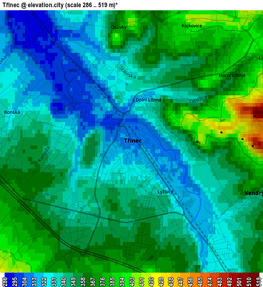
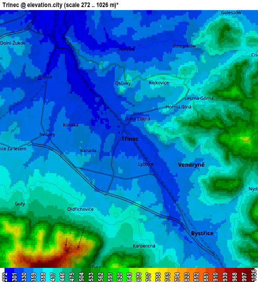
Below is the Elevation map of Třinec, which displays elevation range with different colors. Scale of the first map is from 286 to 519 m (938 to 1703 ft) with average elevation of 348.3 meters (=1143 ft) [note 1]
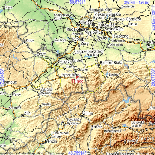
These maps also provides idea of topography and contour of this city, they are displayed at different zoom levels. More info about maps, scale and edge coordinates you can find below images.
| \ | Map #1 | Map #2 | Topo.Map |
| Scale [m] | 286..519 m | 272..1026 m | × |
| Scale [ft] | 938..1703 ft | 892..3366 ft | × |
| Average | 348.3 m = 1143 ft | 398.8 m = 1308 ft | × |
| Width | 6.32 km = 3.9 mi | 12.65 km = 7.9 mi | 202.4 km = 125.8 mi |
| Height | 6.32 km = 3.9 mi | 12.65 km = 7.9 mi | 202.3 km = 125.7 mi |
| ↑Max Latitude | 49.706058° | 49.73447° | 50.5791° |
| Latitude at center | 49.67763° | 49.67763° | 49.67763° |
| ↓Min Latitude | 49.649185° | 49.620724° | 48.75914° |
| ← Min Longitude | 18.626835° | 18.582889° | 17.26453° |
| Longitude center | 18.67078° | 18.67078° | 18.67078° |
| →Max Longitude | 18.714725° | 18.758671° | 20.07703° |
Nearby cities:
Cities around Třinec sort by population:
• Český Těšín elevation 275 m
8.3 km,  337°
337°
• Bystřice 351 m
5.8 km,  141°
141°
• Vendryně 357 m
3.3 km,  111°
111°
• Návsí u Jablunkova 392 m
11.9 km,  147°
147°
• Nýdek 401 m
6.6 km, 111°
• Hrádek 356 m
8.3 km, 144°
• Hnojník 374 m
9.3 km,  273°
273°
• Ropice 300 m
5.1 km,  306°
306°
• Milíkov 423 m
10.8 km,  161°
161°
• Komorní Lhotka 413 m
10.5 km,  258°
258°
• Chotěbuz 348 m
12.5 km,  324°
324°
• Dobratice 397 m
13 km, 261°
Multilingual:
 En español:
Třinec elevación 312 m.
 En France:
Třinec élévation 312 m.


Sources and notes:
- [note 1] Map square and city borders are not equal. Map elevation data is calculated only from area inside that square.
- [src 1] Elevation data from geonames database provided with same terms of usage.
- [src 2] The elevation map of Třinec is generated using elevation data from NASA's 3 arcsec (90m) resolution SRTM data.
- [src 3] Base (background) map © OpenStreetMap contributors tiles are generated by Geofabrik and OpenTopoMap.
Copyright & License:
This Třinec Elevation Map is licensed under CC BY-SA. You may reuse any part from this page, if you give a proper credit by linking to this URL:
 More info on terms of use page.