Vidče elevation
Vidče (Zlín, Okres Vsetín), Czech Republic elevation is 380 meters and Vidče elevation in feet is 1247 ft above sea level [src 1]. Vidče is a populated place (feature code) with elevation that is 35 meters (115 ft) bigger than average city elevation in Czech Republic.
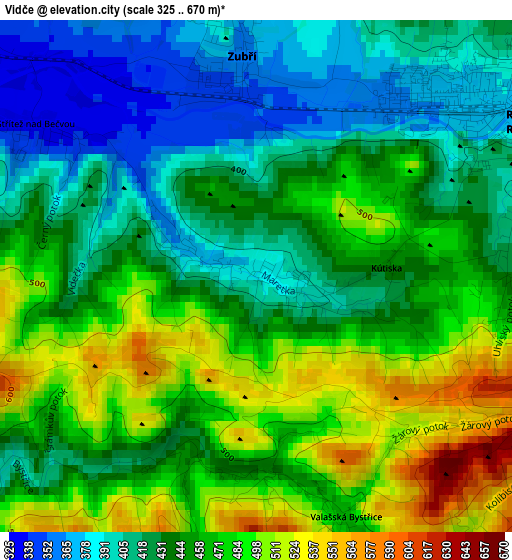
Below is the Elevation map of Vidče, which displays elevation range with different colors. Scale of the first map is from 325 to 670 m (1066 to 2198 ft) with average elevation of 449.7 meters (=1475 ft) [note 1]
These maps also provides idea of topography and contour of this city, they are displayed at different zoom levels. More info about maps, scale and edge coordinates you can find below images.
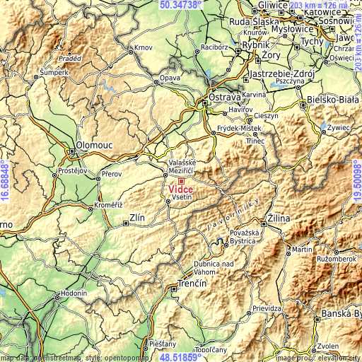
| \ | Map #1 | Topo.Map |
| Scale [m] | 325..670 m | × |
| Scale [ft] | 1066..2198 ft | × |
| Average | 449.7 m = 1475 ft | × |
| Width | 6.35 km = 3.9 mi | 203.3 km = 126.3 mi |
| Height | 6.35 km = 3.9 mi | 203.3 km = 126.3 mi |
| ↑Max Latitude | 49.470076° | 50.34738° |
| Latitude at center | 49.44151° | 49.44151° |
| ↓Min Latitude | 49.412927° | 48.51859° |
| ← Min Longitude | 18.050785° | 16.68848° |
| Longitude center | 18.09473° | 18.09473° |
| →Max Longitude | 18.138675° | 19.50098° |
Nearby cities:
Cities around Vidče sort by population:
• Vsetín elevation 346 m
13.5 km,  211°
211°
• Valašské Meziříčí 311 m
9.5 km,  290°
290°
• Rožnov pod Radhoštěm 378 m
4 km,  61°
61°
• Zubří 358 m
2.7 km,  356°
356°
• Zašová 335 m
5.1 km,  314°
314°
• Mořkov 361 m
10.9 km,  346°
346°
• Valašská Bystřice 463 m
3.1 km,  159°
159°
• Jablůnka 321 m
12.3 km,  238°
238°
• Veřovice 415 m
10.9 km,  7°
7°
• Dolní Bečva 433 m
7.3 km,  78°
78°
• Hodslavice 339 m
11.9 km,  334°
334°
• Prostřední Bečva 465 m
11.4 km,  93°
93°
Multilingual:
 En español:
Vidče elevación 380 m.
 En France:
Vidče élévation 380 m.


Sources and notes:
- [note 1] Map square and city borders are not equal. Map elevation data is calculated only from area inside that square.
- [src 1] Elevation data from geonames database provided with same terms of usage.
- [src 2] The elevation map of Vidče is generated using elevation data from NASA's 3 arcsec (90m) resolution SRTM data.
- [src 3] Base (background) map © OpenStreetMap contributors tiles are generated by Geofabrik and OpenTopoMap.
Copyright & License:
This Vidče Elevation Map is licensed under CC BY-SA. You may reuse any part from this page, if you give a proper credit by linking to this URL:
 More info on terms of use page.