Žacléř elevation
Žacléř (Královéhradecký kraj, Okres Trutnov), Czech Republic elevation is 615 meters and Žacléř elevation in feet is 2018 ft above sea level [src 1]. Žacléř is a populated place (feature code) with elevation that is 270 meters (886 ft) bigger than average city elevation in Czech Republic.
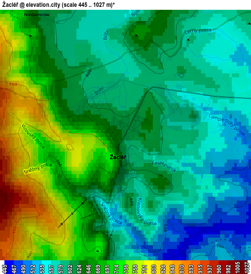
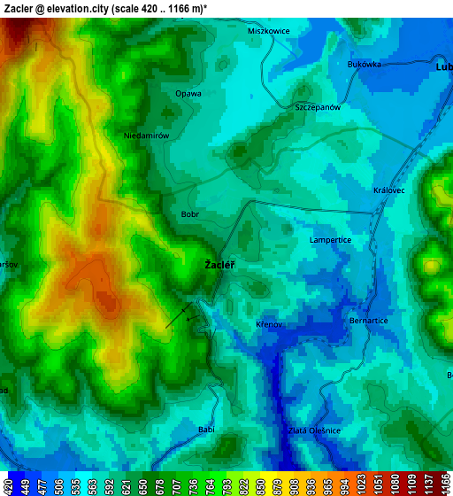
Below is the Elevation map of Žacléř, which displays elevation range with different colors. Scale of the first map is from 445 to 1027 m (1460 to 3369 ft) with average elevation of 633.7 meters (=2079 ft) [note 1]
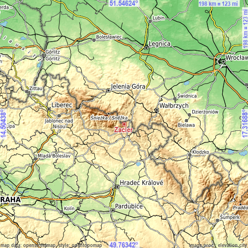
These maps also provides idea of topography and contour of this city, they are displayed at different zoom levels. More info about maps, scale and edge coordinates you can find below images.
| \ | Map #1 | Map #2 | Topo.Map |
| Scale [m] | 445..1027 m | 420..1166 m | × |
| Scale [ft] | 1460..3369 ft | 1378..3825 ft | × |
| Average | 633.7 m = 2079 ft | 640.5 m = 2101 ft | × |
| Width | 6.19 km = 3.8 mi | 12.39 km = 7.7 mi | 198.2 km = 123.2 mi |
| Height | 6.19 km = 3.8 mi | 12.39 km = 7.7 mi | 198.2 km = 123.2 mi |
| ↑Max Latitude | 50.691138° | 50.718969° | 51.54624° |
| Latitude at center | 50.66329° | 50.66329° | 50.66329° |
| ↓Min Latitude | 50.635426° | 50.607545° | 49.76342° |
| ← Min Longitude | 15.866685° | 15.822739° | 14.50438° |
| Longitude center | 15.91063° | 15.91063° | 15.91063° |
| →Max Longitude | 15.954575° | 15.998521° | 17.31688° |
Nearby cities:
Cities around Žacléř sort by population:
• Trutnov elevation 431 m
11.4 km,  179°
179°
• Úpice 357 m
18.4 km,  156°
156°
• Hostinné 359 m
19 km,  224°
224°
• Rtyně v Podkrkonoší 391 m
20.9 km,  147°
147°
• Mladé Buky 486 m
8.3 km, 220°
• Svoboda nad Úpou 518 m
7.8 km,  237°
237°
• Rudník 429 m
14.6 km, 238°
• Teplice nad Metují 467 m
19.9 km,  113°
113°
• Malé Svatoňovice 439 m
17.4 km, 145°
• Velké Svatoňovice 372 m
16.8 km, 150°
• Pilníkov 367 m
15.9 km,  203°
203°
• Radvanice 526 m
15.1 km,  134°
134°
Multilingual:
 En español:
Žacléř elevación 615 m.
 En France:
Žacléř élévation 615 m.


Sources and notes:
- [note 1] Map square and city borders are not equal. Map elevation data is calculated only from area inside that square.
- [src 1] Elevation data from geonames database provided with same terms of usage.
- [src 2] The elevation map of Žacléř is generated using elevation data from NASA's 3 arcsec (90m) resolution SRTM data.
- [src 3] Base (background) map © OpenStreetMap contributors tiles are generated by Geofabrik and OpenTopoMap.
Copyright & License:
This Žacléř Elevation Map is licensed under CC BY-SA. You may reuse any part from this page, if you give a proper credit by linking to this URL:
 More info on terms of use page.