Hostinné elevation
Hostinné (Královéhradecký kraj, Okres Trutnov), Czech Republic elevation is 359 meters and Hostinné elevation in feet is 1178 ft above sea level [src 1]. Hostinné is a populated place (feature code) with elevation that is 14 meters (46 ft) bigger than average city elevation in Czech Republic.
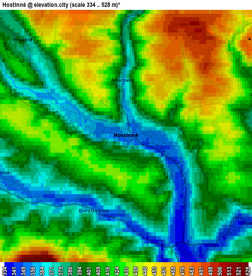
Below is the Elevation map of Hostinné, which displays elevation range with different colors. Scale of the first map is from 334 to 528 m (1096 to 1732 ft) with average elevation of 412.3 meters (=1353 ft) [note 1]
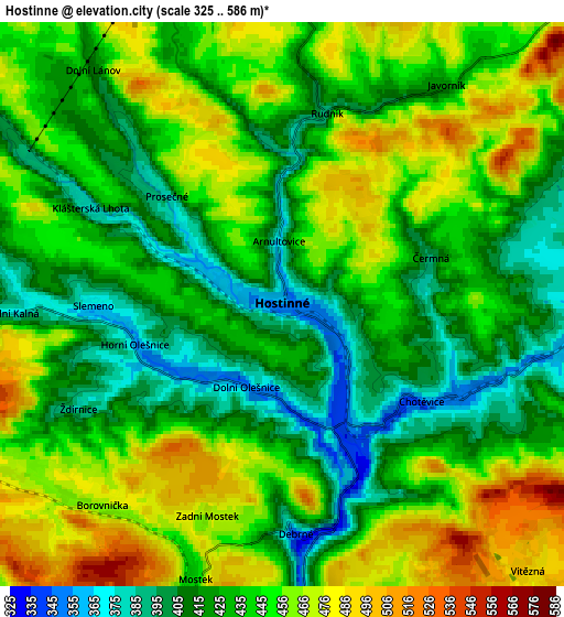
These maps also provides idea of topography and contour of this city, they are displayed at different zoom levels. More info about maps, scale and edge coordinates you can find below images.
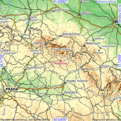
| \ | Map #1 | Map #2 | Topo.Map |
| Scale [m] | 334..528 m | 325..586 m | × |
| Scale [ft] | 1096..1732 ft | 1066..1923 ft | × |
| Average | 412.3 m = 1353 ft | 439.8 m = 1443 ft | × |
| Width | 6.21 km = 3.9 mi | 12.42 km = 7.7 mi | 198.7 km = 123.5 mi |
| Height | 6.21 km = 3.9 mi | 12.42 km = 7.7 mi | 198.7 km = 123.5 mi |
| ↑Max Latitude | 50.56858° | 50.596484° | 51.42592° |
| Latitude at center | 50.54066° | 50.54066° | 50.54066° |
| ↓Min Latitude | 50.512723° | 50.48477° | 49.63846° |
| ← Min Longitude | 15.679395° | 15.635449° | 14.31709° |
| Longitude center | 15.72334° | 15.72334° | 15.72334° |
| →Max Longitude | 15.767285° | 15.811231° | 17.12959° |
Nearby cities:
Cities around Hostinné sort by population:
• Trutnov elevation 431 m
13.6 km,  80°
80°
• Vrchlabí 487 m
12.5 km,  320°
320°
• Mladé Buky 486 m
10.7 km,  46°
46°
• Svoboda nad Úpou 518 m
11.5 km,  34°
34°
• Rudník 429 m
6.1 km,  6°
6°
• Horní Branná 460 m
13.1 km,  305°
305°
• Studenec 535 m
12.4 km,  276°
276°
• Mostek 440 m
6.3 km,  197°
197°
• Zadní Mostek 460 m
5.2 km, 200°
• Bílá Třemešná 352 m
10.7 km,  173°
173°
• Pecka 419 m
10.5 km,  230°
230°
• Pilníkov 367 m
6.9 km,  97°
97°
Multilingual:
 En español:
Hostinné elevación 359 m.
 En France:
Hostinné élévation 359 m.
 Auf Deutsch:
Hostinné höhe über dem Meeresspiegel ist 359 m.

Sources and notes:
- [note 1] Map square and city borders are not equal. Map elevation data is calculated only from area inside that square.
- [src 1] Elevation data from geonames database provided with same terms of usage.
- [src 2] The elevation map of Hostinné is generated using elevation data from NASA's 3 arcsec (90m) resolution SRTM data.
- [src 3] Base (background) map © OpenStreetMap contributors tiles are generated by Geofabrik and OpenTopoMap.
Copyright & License:
This Hostinné Elevation Map is licensed under CC BY-SA. You may reuse any part from this page, if you give a proper credit by linking to this URL:
 More info on terms of use page.