Železný Brod elevation
Železný Brod (Liberecký kraj, Okres Jablonec nad Nisou), Czech Republic elevation is 282 meters and Železný Brod elevation in feet is 925 ft above sea level [src 1]. Železný Brod is a populated place (feature code) with elevation that is 63 meters (207 ft) smaller than average city elevation in Czech Republic.
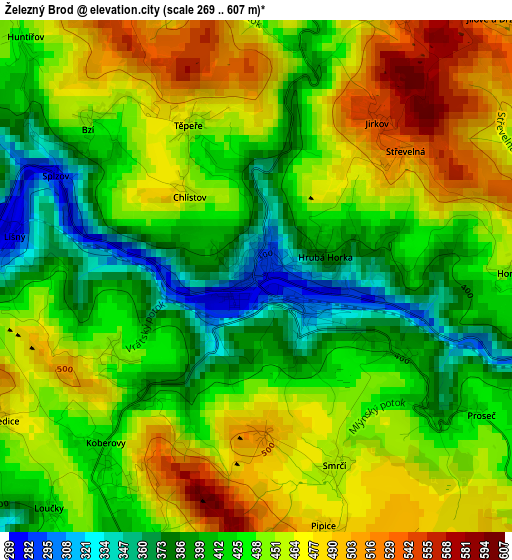
Below is the Elevation map of Železný Brod, which displays elevation range with different colors. Scale of the first map is from 269 to 607 m (883 to 1991 ft) with average elevation of 437.7 meters (=1436 ft) [note 1]
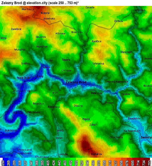
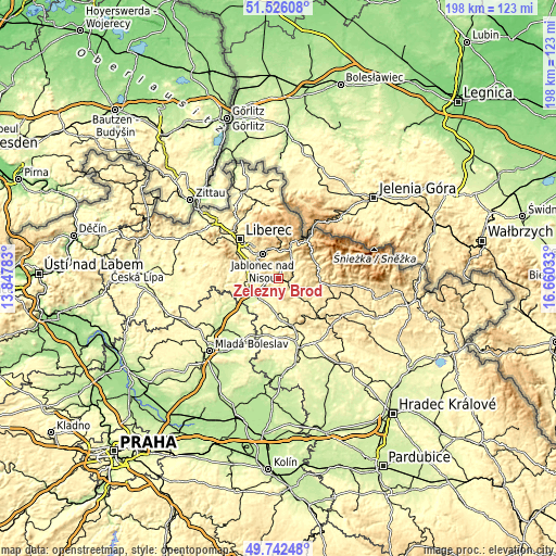
These maps also provides idea of topography and contour of this city, they are displayed at different zoom levels. More info about maps, scale and edge coordinates you can find below images.
| \ | Map #1 | Map #2 | Topo.Map |
| Scale [m] | 269..607 m | 250..753 m | × |
| Scale [ft] | 883..1991 ft | 820..2470 ft | × |
| Average | 437.7 m = 1436 ft | 452.2 m = 1484 ft | × |
| Width | 6.2 km = 3.9 mi | 12.39 km = 7.7 mi | 198.3 km = 123.2 mi |
| Height | 6.2 km = 3.9 mi | 12.39 km = 7.7 mi | 198.3 km = 123.2 mi |
| ↑Max Latitude | 50.6706° | 50.698443° | 51.52608° |
| Latitude at center | 50.64274° | 50.64274° | 50.64274° |
| ↓Min Latitude | 50.614864° | 50.586971° | 49.74248° |
| ← Min Longitude | 15.210135° | 15.166189° | 13.84783° |
| Longitude center | 15.25408° | 15.25408° | 15.25408° |
| →Max Longitude | 15.298025° | 15.341971° | 16.66033° |
Nearby cities:
Cities around Železný Brod sort by population:
• Jablonec nad Nisou elevation 518 m
10.8 km,  327°
327°
• Turnov 255 m
9.8 km,  227°
227°
• Semily 321 m
7.3 km,  128°
128°
• Tanvald 479 m
11.1 km,  19°
19°
• Smržovka 583 m
10.6 km,  357°
357°
• Velké Hamry 411 m
9 km,  28°
28°
• Pěnčín 560 m
5.2 km,  345°
345°
• Lučany nad Nisou 593 m
11.2 km, 347°
• Vysoké nad Jizerou 699 m
11.4 km,  65°
65°
• Plavy 399 m
8.1 km, 33°
• Malá Skála 326 m
4.2 km,  275°
275°
• Ohrazenice 288 m
10.3 km,  240°
240°
Multilingual:
 En español:
Železný Brod elevación 282 m.
 En France:
Železný Brod élévation 282 m.
 Auf Deutsch:
Eisenbrod höhe über dem Meeresspiegel ist 282 m.

Sources and notes:
- [note 1] Map square and city borders are not equal. Map elevation data is calculated only from area inside that square.
- [src 1] Elevation data from geonames database provided with same terms of usage.
- [src 2] The elevation map of Železný Brod is generated using elevation data from NASA's 3 arcsec (90m) resolution SRTM data.
- [src 3] Base (background) map © OpenStreetMap contributors tiles are generated by Geofabrik and OpenTopoMap.
Copyright & License:
This Železný Brod Elevation Map is licensed under CC BY-SA. You may reuse any part from this page, if you give a proper credit by linking to this URL:
 More info on terms of use page.