Astromerítis elevation
Astromerítis (Nicosia), Cyprus elevation is 158 meters and Astromerítis elevation in feet is 518 ft above sea level [src 1]. Astromerítis is a populated place (feature code) with elevation that is 20 meters (66 ft) smaller than average city elevation in Cyprus.
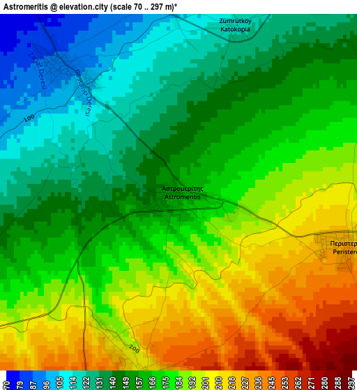
Below is the Elevation map of Astromerítis, which displays elevation range with different colors. Scale of the first map is from 70 to 297 m (230 to 974 ft) with average elevation of 168.7 meters (=553 ft) [note 1]
These maps also provides idea of topography and contour of this city, they are displayed at different zoom levels. More info about maps, scale and edge coordinates you can find below images.
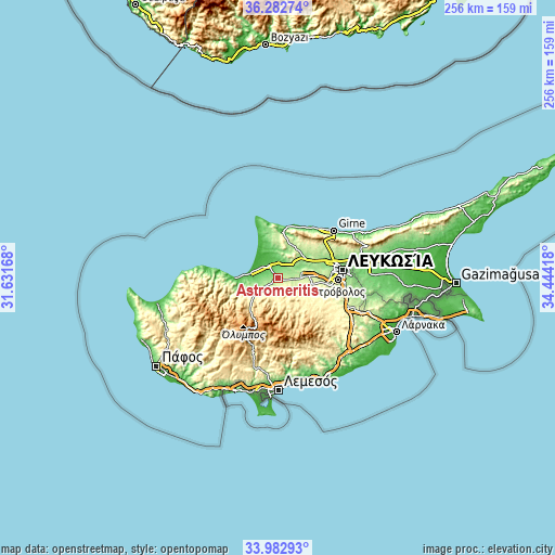
| \ | Map #1 | Topo.Map |
| Scale [m] | 70..297 m | × |
| Scale [ft] | 230..974 ft | × |
| Average | 168.7 m = 553 ft | × |
| Width | 7.99 km = 5 mi | 255.7 km = 158.9 mi |
| Height | 7.99 km = 5 mi | 255.7 km = 158.9 mi |
| ↑Max Latitude | 35.176888° | 36.28274° |
| Latitude at center | 35.14096° | 35.14096° |
| ↓Min Latitude | 35.105016° | 33.98293° |
| ← Min Longitude | 32.993985° | 31.63168° |
| Longitude center | 33.03793° | 33.03793° |
| →Max Longitude | 33.081875° | 34.44418° |
Nearby cities:
Cities around Astromerítis sort by population:
• Mórfou elevation 48 m
7.6 km,  327°
327°
• Léfka 129 m
17.4 km,  259°
259°
• Kokkinotrimithiá 218 m
14.8 km,  84°
84°
• Akáki 207 m
8.3 km,  95°
95°
• Peristeróna 230 m
3.9 km,  109°
109°
• Páno Defterá 292 m
21.9 km, 108°
• Ergátes 336 m
21 km,  117°
117°
• Klírou 451 m
18.5 km,  136°
136°
• Kakopetriá 694 m
20.9 km,  215°
215°
• Aredioú 362 m
17.7 km,  125°
125°
• Mámmari 171 m
15.6 km, 75°
• Méniko 248 m
10.3 km, 109°
Multilingual:
 En español:
Astromerítis elevación 158 m.
 En France:
Astromerítis élévation 158 m.
 Auf Deutsch:
Astromerítis höhe über dem Meeresspiegel ist 158 m.

Sources and notes:
- [note 1] Map square and city borders are not equal. Map elevation data is calculated only from area inside that square.
- [src 1] Elevation data from geonames database provided with same terms of usage.
- [src 2] The elevation map of Astromerítis is generated using elevation data from NASA's 3 arcsec (90m) resolution SRTM data.
- [src 3] Base (background) map © OpenStreetMap contributors tiles are generated by Geofabrik and OpenTopoMap.
Copyright & License:
This Astromerítis Elevation Map is licensed under CC BY-SA. You may reuse any part from this page, if you give a proper credit by linking to this URL:
 More info on terms of use page.