Kyrenia elevation
Kyrenia (Keryneia), Cyprus elevation is 20 meters and Kyrenia elevation in feet is 66 ft above sea level [src 1]. Kyrenia is a seat of a first-order administrative division (feature code) with elevation that is 158 meters (518 ft) smaller than average city elevation in Cyprus.
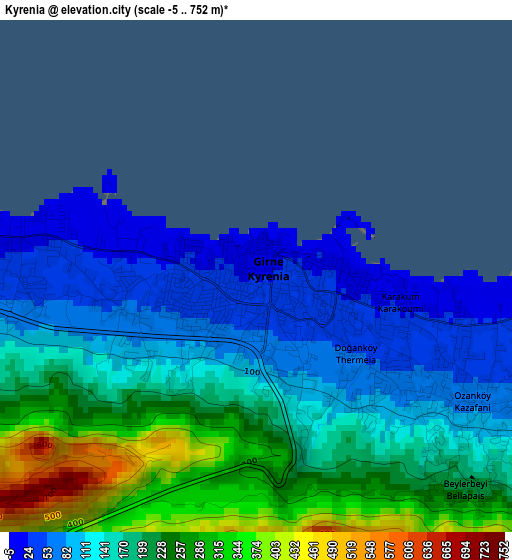
Below is the Elevation map of Kyrenia, which displays elevation range with different colors. Scale of the first map is from -5 to 752 m (-16 to 2467 ft) with average elevation of 174.7 meters (=573 ft) [note 1]
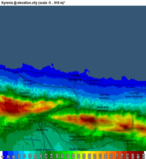
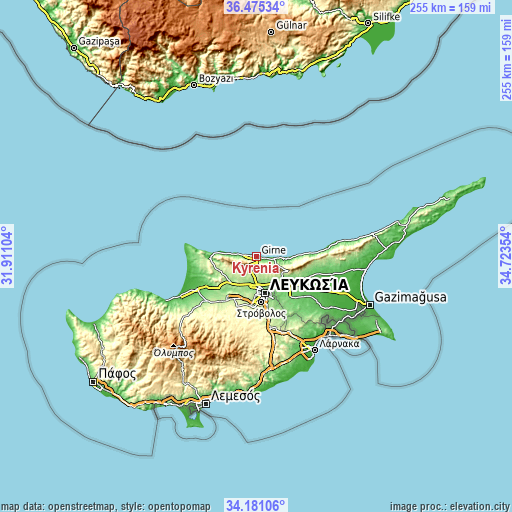
These maps also provides idea of topography and contour of this city, they are displayed at different zoom levels. More info about maps, scale and edge coordinates you can find below images.
| \ | Map #1 | Map #2 | Topo.Map |
| Scale [m] | -5..752 m | -5..916 m | × |
| Scale [ft] | -16..2467 ft | -16..3005 ft | × |
| Average | 174.7 m = 573 ft | 283.3 m = 929 ft | × |
| Width | 7.97 km = 5 mi | 15.94 km = 9.9 mi | 255.1 km = 158.5 mi |
| Height | 7.97 km = 5 mi | 15.94 km = 9.9 mi | 255.1 km = 158.5 mi |
| ↑Max Latitude | 35.372181° | 35.408007° | 36.47534° |
| Latitude at center | 35.33634° | 35.33634° | 35.33634° |
| ↓Min Latitude | 35.300483° | 35.26461° | 34.18106° |
| ← Min Longitude | 33.273345° | 33.229399° | 31.91104° |
| Longitude center | 33.31729° | 33.31729° | 33.31729° |
| →Max Longitude | 33.361235° | 33.405181° | 34.72354° |
Nearby cities:
Cities around Kyrenia sort by population:
• Nicosia elevation 147 m
18.4 km,  166°
166°
• Géri 159 m
27.3 km,  160°
160°
• Tséri 271 m
29.3 km,  178°
178°
• Lápithos 85 m
13 km,  270°
270°
• Kokkinotrimithiá 218 m
23 km,  207°
207°
• Akáki 207 m
28.3 km,  217°
217°
• Peristeróna 230 m
31.6 km, 223°
• Páno Defterá 292 m
29.1 km,  189°
189°
• Káto Defterá 277 m
28.2 km, 187°
• Psimolofou 316 m
30.9 km, 189°
• Mámmari 171 m
20.6 km, 209°
• Méniko 248 m
29.7 km, 211°
Multilingual:
 En español:
Kyrenia elevación 20 m.
 En France:
Kyrenia élévation 20 m.


Sources and notes:
- [note 1] Map square and city borders are not equal. Map elevation data is calculated only from area inside that square.
- [src 1] Elevation data from geonames database provided with same terms of usage.
- [src 2] The elevation map of Kyrenia is generated using elevation data from NASA's 3 arcsec (90m) resolution SRTM data.
- [src 3] Base (background) map © OpenStreetMap contributors tiles are generated by Geofabrik and OpenTopoMap.
Copyright & License:
This Kyrenia Elevation Map is licensed under CC BY-SA. You may reuse any part from this page, if you give a proper credit by linking to this URL:
 More info on terms of use page.