Calheta elevation
Calheta (São Miguel), Cape Verde elevation is 7 meters and Calheta elevation in feet is 23 ft above sea level [src 1]. Calheta is a seat of a first-order administrative division (feature code) with elevation that is 111 meters (364 ft) smaller than average city elevation in Cape Verde.
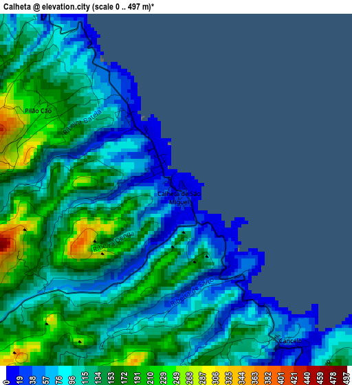
Below is the Elevation map of Calheta, which displays elevation range with different colors. Scale of the first map is from 0 to 497 m (0 to 1631 ft) with average elevation of 123.5 meters (=405 ft) [note 1]
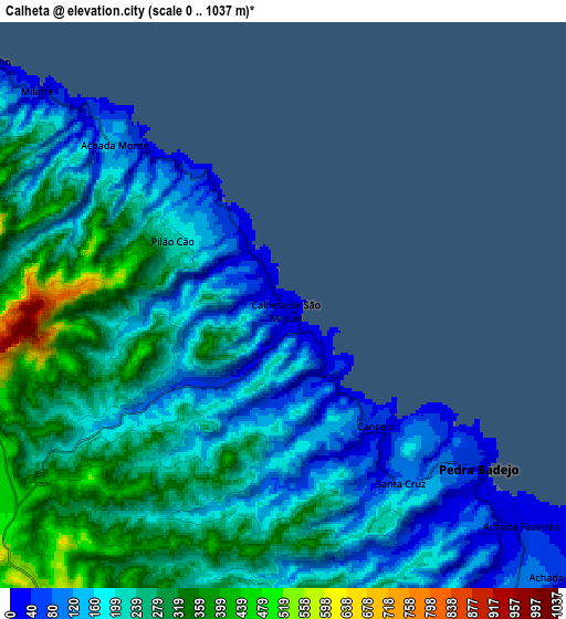
These maps also provides idea of topography and contour of this city, they are displayed at different zoom levels. More info about maps, scale and edge coordinates you can find below images.
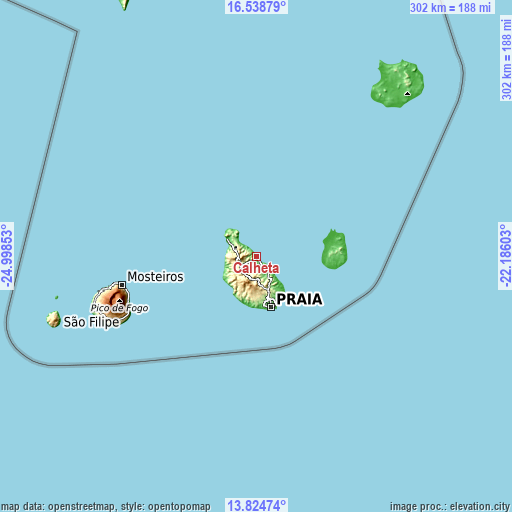
| \ | Map #1 | Map #2 | Topo.Map |
| Scale [m] | 0..497 m | 0..1037 m | × |
| Scale [ft] | 0..1631 ft | 0..3402 ft | × |
| Average | 123.5 m = 405 ft | 215.3 m = 706 ft | × |
| Width | 9.43 km = 5.9 mi | 18.86 km = 11.7 mi | 301.8 km = 187.5 mi |
| Height | 9.43 km = 5.9 mi | 18.86 km = 11.7 mi | 301.8 km = 187.5 mi |
| ↑Max Latitude | 15.228536° | 15.270934° | 16.53879° |
| Latitude at center | 15.18613° | 15.18613° | 15.18613° |
| ↓Min Latitude | 15.143715° | 15.101292° | 13.82474° |
| ← Min Longitude | -23.636225° | -23.680171° | -24.99853° |
| Longitude center | -23.59228° | -23.59228° | -23.59228° |
| →Max Longitude | -23.548335° | -23.504389° | -22.18603° |
Nearby cities:
Cities around Calheta sort by population:
• Praia elevation 18 m
29.6 km,  163°
163°
• Cova Figueira 480 m
82.2 km,  246°
246°
• Santa Cruz 45 m
6.5 km,  154°
154°
• Pedra Badejo 35 m
8.5 km,  129°
129°
• Assomada 391 m
13.7 km,  225°
225°
• Tarrafal 17 m
20 km,  301°
301°
• Picos 432 m
12.2 km,  200°
200°
• Vila do Maio 22 m
41.2 km,  97°
97°
• Cidade Velha 5 m
30.1 km,  182°
182°
• São Domingos 327 m
18.3 km,  169°
169°
• Igreja 15 m
80.5 km,  257°
257°
• João Teves 299 m
13.3 km, 178°
Multilingual:
 En español:
Calheta elevación 7 m.
 En France:
Calheta élévation 7 m.


Sources and notes:
- [note 1] Map square and city borders are not equal. Map elevation data is calculated only from area inside that square.
- [src 1] Elevation data from geonames database provided with same terms of usage.
- [src 2] The elevation map of Calheta is generated using elevation data from NASA's 3 arcsec (90m) resolution SRTM data.
- [src 3] Base (background) map © OpenStreetMap contributors tiles are generated by Geofabrik and OpenTopoMap.
Copyright & License:
This Calheta Elevation Map is licensed under CC BY-SA. You may reuse any part from this page, if you give a proper credit by linking to this URL:
 More info on terms of use page.