La Salud elevation
La Salud (Mayabeque), Cuba elevation is 62 meters and La Salud elevation in feet is 203 ft above sea level [src 1]. La Salud is a populated place (feature code) with elevation that is 7 meters (23 ft) smaller than average city elevation in Cuba.
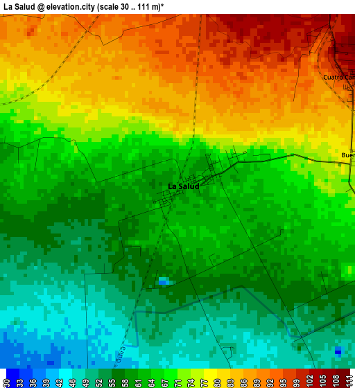
Below is the Elevation map of La Salud, which displays elevation range with different colors. Scale of the first map is from 30 to 111 m (98 to 364 ft) with average elevation of 67.8 meters (=222 ft) [note 1]
These maps also provides idea of topography and contour of this city, they are displayed at different zoom levels. More info about maps, scale and edge coordinates you can find below images.
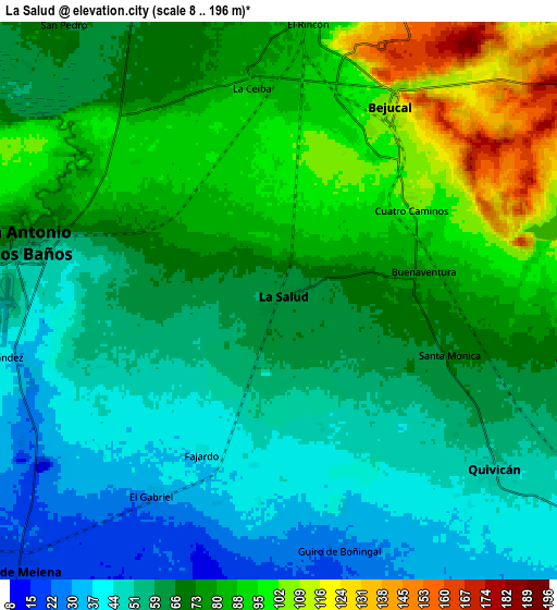
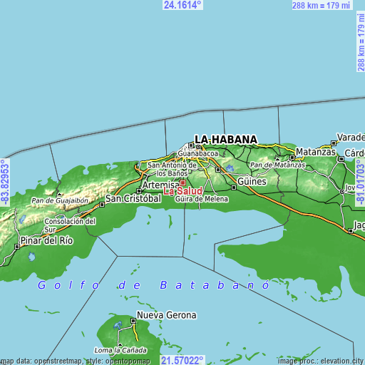
| \ | Map #1 | Map #2 | Topo.Map |
| Scale [m] | 30..111 m | 8..196 m | × |
| Scale [ft] | 98..364 ft | 26..643 ft | × |
| Average | 67.8 m = 222 ft | 68.8 m = 226 ft | × |
| Width | 9 km = 5.6 mi | 18.01 km = 11.2 mi | 288.1 km = 179 mi |
| Height | 9 km = 5.6 mi | 18.01 km = 11.2 mi | 288.1 km = 179 mi |
| ↑Max Latitude | 22.912474° | 22.952946° | 24.1614° |
| Latitude at center | 22.87199° | 22.87199° | 22.87199° |
| ↓Min Latitude | 22.831494° | 22.790986° | 21.57022° |
| ← Min Longitude | -82.467225° | -82.511171° | -83.82953° |
| Longitude center | -82.42328° | -82.42328° | -82.42328° |
| →Max Longitude | -82.379335° | -82.335389° | -81.01703° |
Nearby cities:
Cities around La Salud sort by population:
• Arroyo Naranjo elevation 80 m
19.1 km,  16°
16°
• Boyeros 66 m
15.2 km,  8°
8°
• Güira de Melena 21 m
12 km,  225°
225°
• Bauta 70 m
17.6 km,  314°
314°
• San Antonio de los Baños 60 m
8.2 km,  284°
284°
• Santiago de las Vegas 95 m
11.5 km, 18°
• Bejucal 110 m
7.2 km,  29°
29°
• Alquízar 21 m
18.1 km,  245°
245°
• Batabanó 10 m
21.9 km,  141°
141°
• Quivicán 51 m
8.8 km,  128°
128°
• Guara 47 m
23.6 km,  106°
106°
• Caimito 74 m
19.6 km,  296°
296°
Multilingual:
 En español:
La Salud elevación 62 m.
 En France:
La Salud élévation 62 m.


Sources and notes:
- [note 1] Map square and city borders are not equal. Map elevation data is calculated only from area inside that square.
- [src 1] Elevation data from geonames database provided with same terms of usage.
- [src 2] The elevation map of La Salud is generated using elevation data from NASA's 3 arcsec (90m) resolution SRTM data.
- [src 3] Base (background) map © OpenStreetMap contributors tiles are generated by Geofabrik and OpenTopoMap.
Copyright & License:
This La Salud Elevation Map is licensed under CC BY-SA. You may reuse any part from this page, if you give a proper credit by linking to this URL:
 More info on terms of use page.