Matanzas elevation
Matanzas, Cuba elevation is 6 meters and Matanzas elevation in feet is 20 ft above sea level [src 1]. Matanzas is a seat of a first-order administrative division (feature code) with elevation that is 63 meters (207 ft) smaller than average city elevation in Cuba.
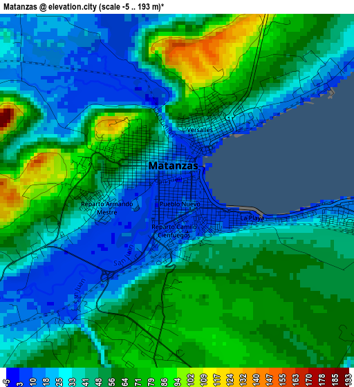
Below is the Elevation map of Matanzas, which displays elevation range with different colors. Scale of the first map is from -5 to 193 m (-16 to 633 ft) with average elevation of 47.4 meters (=156 ft) [note 1]
These maps also provides idea of topography and contour of this city, they are displayed at different zoom levels. More info about maps, scale and edge coordinates you can find below images.
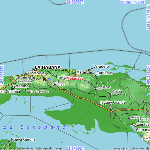
| \ | Map #1 | Map #2 | Topo.Map |
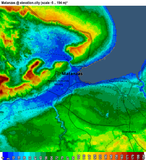
| Scale [m] | -5..193 m | -5..194 m | × |
| Scale [ft] | -16..633 ft | -16..636 ft | × |
| Average | 47.4 m = 156 ft | 64.6 m = 212 ft | × |
| Width | 8.99 km = 5.6 mi | 17.99 km = 11.2 mi | 287.8 km = 178.8 mi |
| Height | 8.99 km = 5.6 mi | 17.99 km = 11.2 mi | 287.8 km = 178.8 mi |
| ↑Max Latitude | 23.081543° | 23.121965° | 24.32887° |
| Latitude at center | 23.04111° | 23.04111° | 23.04111° |
| ↓Min Latitude | 23.000664° | 22.960207° | 21.74092° |
| ← Min Longitude | -81.621445° | -81.665391° | -82.98375° |
| Longitude center | -81.5775° | -81.5775° | -81.5775° |
| →Max Longitude | -81.533555° | -81.489609° | -80.17125° |
Nearby cities:
Cities around Matanzas sort by population:
• Cárdenas elevation 9 m
38 km,  90°
90°
• Madruga 150 m
32.1 km,  242°
242°
• Unión de Reyes 57 m
27.7 km,  171°
171°
• Pedro Betancourt 24 m
45.7 km,  139°
139°
• Limonar 71 m
19.8 km,  120°
120°
• Jaruco 134 m
44.2 km,  270°
270°
• Varadero 8 m
36.4 km,  69°
69°
• Santa Cruz del Norte 11 m
37.8 km,  289°
289°
• San Nicolás de Bari 31 m
44.7 km,  230°
230°
• Bolondrón 52 m
33.6 km,  156°
156°
• Alacranes 31 m
30.5 km,  178°
178°
• Nueva Paz 22 m
36 km,  210°
210°
Multilingual:
 En español:
San Carlos y San Severino de Matanzas elevación 6 m.
 En France:
Matanzas élévation 6 m.


Sources and notes:
- [note 1] Map square and city borders are not equal. Map elevation data is calculated only from area inside that square.
- [src 1] Elevation data from geonames database provided with same terms of usage.
- [src 2] The elevation map of Matanzas is generated using elevation data from NASA's 3 arcsec (90m) resolution SRTM data.
- [src 3] Base (background) map © OpenStreetMap contributors tiles are generated by Geofabrik and OpenTopoMap.
Copyright & License:
This Matanzas Elevation Map is licensed under CC BY-SA. You may reuse any part from this page, if you give a proper credit by linking to this URL:
 More info on terms of use page.