Sagua la Grande elevation
Sagua la Grande (Villa Clara), Cuba elevation is 13 meters and Sagua la Grande elevation in feet is 43 ft above sea level [src 1]. Sagua la Grande is a seat of a second-order administrative division (feature code) with elevation that is 56 meters (184 ft) smaller than average city elevation in Cuba.
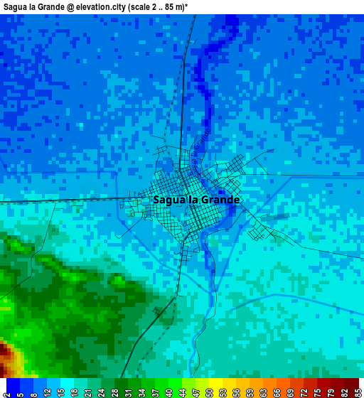
Below is the Elevation map of Sagua la Grande, which displays elevation range with different colors. Scale of the first map is from 2 to 85 m (7 to 279 ft) with average elevation of 15.5 meters (=51 ft) [note 1]
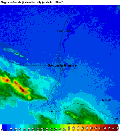
These maps also provides idea of topography and contour of this city, they are displayed at different zoom levels. More info about maps, scale and edge coordinates you can find below images.
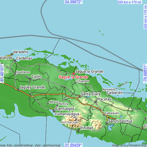
| \ | Map #1 | Map #2 | Topo.Map |
| Scale [m] | 2..85 m | 0..178 m | × |
| Scale [ft] | 7..279 ft | 0..584 ft | × |
| Average | 15.5 m = 51 ft | 20.1 m = 66 ft | × |
| Width | 9.01 km = 5.6 mi | 18.02 km = 11.2 mi | 288.3 km = 179.1 mi |
| Height | 9.01 km = 5.6 mi | 18.02 km = 11.2 mi | 288.3 km = 179.1 mi |
| ↑Max Latitude | 22.847174° | 22.887665° | 24.09672° |
| Latitude at center | 22.80667° | 22.80667° | 22.80667° |
| ↓Min Latitude | 22.766154° | 22.725627° | 21.50429° |
| ← Min Longitude | -80.119505° | -80.163451° | -81.48181° |
| Longitude center | -80.07556° | -80.07556° | -80.07556° |
| →Max Longitude | -80.031615° | -79.987669° | -78.66931° |
Nearby cities:
Cities around Sagua la Grande sort by population:
• Santa Clara elevation 126 m
45.9 km,  165°
165°
• Santo Domingo 51 m
29.9 km,  215°
215°
• Ranchuelo 108 m
48.9 km,  189°
189°
• Cifuentes 63 m
17.7 km, 171°
• Camajuaní 81 m
49.1 km,  137°
137°
• Encrucijada 56 m
30 km,  134°
134°
• Lajas 78 m
49 km,  207°
207°
• Quemado de Güines 85 m
18.2 km,  263°
263°
• Esperanza 99 m
40.1 km,  183°
183°
• Calabazar de Sagua 60 m
25.8 km, 134°
• Rancho Veloz 59 m
33.3 km,  284°
284°
• Isabela de Sagua 5 m
16.1 km,  23°
23°
Multilingual:
 En español:
Sagua la Grande elevación 13 m.
 En France:
Sagua la Grande élévation 13 m.
 Auf Deutsch:
Sagua la Grande höhe über dem Meeresspiegel ist 13 m.

Sources and notes:
- [note 1] Map square and city borders are not equal. Map elevation data is calculated only from area inside that square.
- [src 1] Elevation data from geonames database provided with same terms of usage.
- [src 2] The elevation map of Sagua la Grande is generated using elevation data from NASA's 3 arcsec (90m) resolution SRTM data.
- [src 3] Base (background) map © OpenStreetMap contributors tiles are generated by Geofabrik and OpenTopoMap.
Copyright & License:
This Sagua la Grande Elevation Map is licensed under CC BY-SA. You may reuse any part from this page, if you give a proper credit by linking to this URL:
 More info on terms of use page.