Santa Clara elevation
Santa Clara (Villa Clara), Cuba elevation is 126 meters and Santa Clara elevation in feet is 413 ft above sea level [src 1]. Santa Clara is a seat of a first-order administrative division (feature code) with elevation that is 57 meters (187 ft) bigger than average city elevation in Cuba.
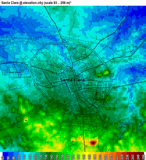
Below is the Elevation map of Santa Clara, which displays elevation range with different colors. Scale of the first map is from 83 to 256 m (272 to 840 ft) with average elevation of 125.5 meters (=412 ft) [note 1]
These maps also provides idea of topography and contour of this city, they are displayed at different zoom levels. More info about maps, scale and edge coordinates you can find below images.
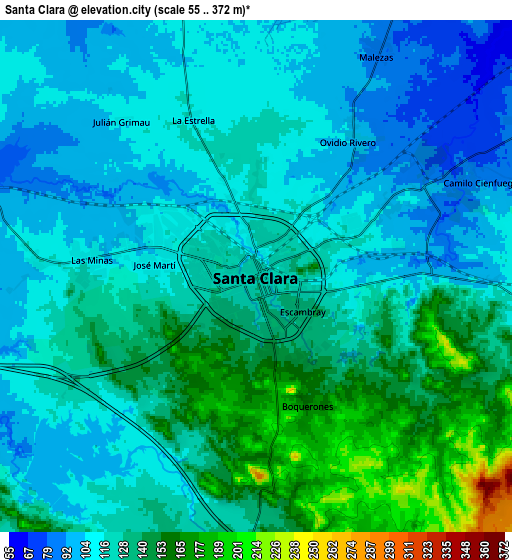
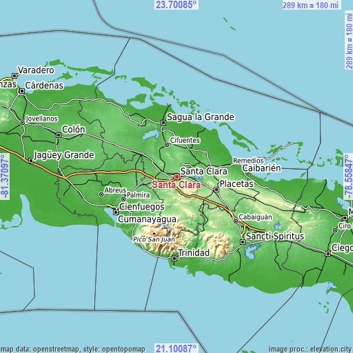
| \ | Map #1 | Map #2 | Topo.Map |
| Scale [m] | 83..256 m | 55..372 m | × |
| Scale [ft] | 272..840 ft | 180..1220 ft | × |
| Average | 125.5 m = 412 ft | 124.5 m = 408 ft | × |
| Width | 9.03 km = 5.6 mi | 18.07 km = 11.2 mi | 289.1 km = 179.6 mi |
| Height | 9.03 km = 5.6 mi | 18.07 km = 11.2 mi | 289.1 km = 179.6 mi |
| ↑Max Latitude | 22.447561° | 22.488171° | 23.70085° |
| Latitude at center | 22.40694° | 22.40694° | 22.40694° |
| ↓Min Latitude | 22.366307° | 22.325661° | 21.10087° |
| ← Min Longitude | -80.008665° | -80.052611° | -81.37097° |
| Longitude center | -79.96472° | -79.96472° | -79.96472° |
| →Max Longitude | -79.920775° | -79.876829° | -78.55847° |
Nearby cities:
Cities around Santa Clara sort by population:
• Placetas elevation 201 m
33.6 km,  108°
108°
• Santo Domingo 51 m
34.9 km,  305°
305°
• Ranchuelo 108 m
19.5 km,  258°
258°
• Manicaragua 144 m
28.6 km,  182°
182°
• Cifuentes 63 m
28.3 km,  342°
342°
• Camajuaní 81 m
23.6 km,  68°
68°
• Encrucijada 56 m
25.6 km,  23°
23°
• Cruces 94 m
32.2 km, 257°
• Lajas 78 m
33.8 km,  271°
271°
• Esperanza 99 m
14.3 km,  288°
288°
• Calabazar de Sagua 60 m
27.4 km, 15°
• Camajuaní 112 m
25.6 km,  75°
75°
Multilingual:
 En español:
Santa Clara elevación 126 m.
 En France:
Santa Clara élévation 126 m.
 Auf Deutsch:
Santa Clara höhe über dem Meeresspiegel ist 126 m.
 На русском:
Санта Клара, Санта-Клара высота над уровнем моря 126 м
Sources and notes:
- [note 1] Map square and city borders are not equal. Map elevation data is calculated only from area inside that square.
- [src 1] Elevation data from geonames database provided with same terms of usage.
- [src 2] The elevation map of Santa Clara is generated using elevation data from NASA's 3 arcsec (90m) resolution SRTM data.
- [src 3] Base (background) map © OpenStreetMap contributors tiles are generated by Geofabrik and OpenTopoMap.
Copyright & License:
This Santa Clara Elevation Map is licensed under CC BY-SA. You may reuse any part from this page, if you give a proper credit by linking to this URL:
 More info on terms of use page.