Aipe elevation
Aipe (Huila), Colombia elevation is 393 meters and Aipe elevation in feet is 1289 ft above sea level [src 1]. Aipe is a seat of a second-order administrative division (feature code) with elevation that is 756 meters (2480 ft) smaller than average city elevation in Colombia.
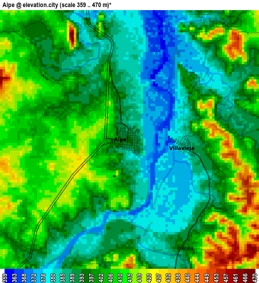
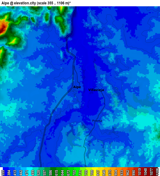
Below is the Elevation map of Aipe, which displays elevation range with different colors. Scale of the first map is from 359 to 470 m (1178 to 1542 ft) with average elevation of 398.7 meters (=1308 ft) [note 1]
These maps also provides idea of topography and contour of this city, they are displayed at different zoom levels. More info about maps, scale and edge coordinates you can find below images.
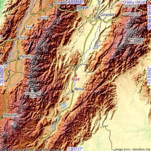
| \ | Map #1 | Map #2 | Topo.Map |
| Scale [m] | 359..470 m | 355..1106 m | × |
| Scale [ft] | 1178..1542 ft | 1165..3629 ft | × |
| Average | 398.7 m = 1308 ft | 428.4 m = 1406 ft | × |
| Width | 9.76 km = 6.1 mi | 19.51 km = 12.1 mi | 312.2 km = 194 mi |
| Height | 9.76 km = 6.1 mi | 19.51 km = 12.1 mi | 312.2 km = 194 mi |
| ↑Max Latitude | 3.266095° | 3.309968° | 4.62514° |
| Latitude at center | 3.22222° | 3.22222° | 3.22222° |
| ↓Min Latitude | 3.178343° | 3.134465° | 1.81737° |
| ← Min Longitude | -75.280615° | -75.324561° | -76.64292° |
| Longitude center | -75.23667° | -75.23667° | -75.23667° |
| →Max Longitude | -75.192725° | -75.148779° | -73.83042° |
Nearby cities:
Cities around Aipe sort by population:
• Neiva elevation 461 m
33.2 km,  188°
188°
• Natagaima 326 m
47 km,  19°
19°
• Palermo 546 m
43 km,  211°
211°
• Planadas 1212 m
45.4 km,  266°
266°
• Rivera 731 m
49.5 km,  182°
182°
• Santa Isabel 1094 m
31.8 km,  63°
63°
• Tello 581 m
20.5 km,  147°
147°
• Baraya 612 m
21.8 km,  110°
110°
• Ataco 453 m
44.1 km,  338°
338°
• Santiago Pérez 690 m
45.3 km,  295°
295°
• Villavieja 384 m
2 km,  95°
95°
• Alpujarra 1307 m
38.6 km, 60°
Multilingual:
 En español:
Aipe elevación 393 m.
 En France:
Aipe élévation 393 m.


Sources and notes:
- [note 1] Map square and city borders are not equal. Map elevation data is calculated only from area inside that square.
- [src 1] Elevation data from geonames database provided with same terms of usage.
- [src 2] The elevation map of Aipe is generated using elevation data from NASA's 3 arcsec (90m) resolution SRTM data.
- [src 3] Base (background) map © OpenStreetMap contributors tiles are generated by Geofabrik and OpenTopoMap.
Copyright & License:
This Aipe Elevation Map is licensed under CC BY-SA. You may reuse any part from this page, if you give a proper credit by linking to this URL:
 More info on terms of use page.