Neiva elevation
Neiva (Huila), Colombia elevation is 461 meters and Neiva elevation in feet is 1512 ft above sea level [src 1]. Neiva is a seat of a first-order administrative division (feature code) with elevation that is 688 meters (2257 ft) smaller than average city elevation in Colombia.
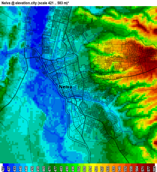
Below is the Elevation map of Neiva, which displays elevation range with different colors. Scale of the first map is from 421 to 583 m (1381 to 1913 ft) with average elevation of 470.4 meters (=1543 ft) [note 1]
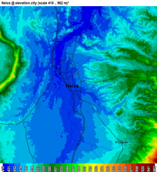
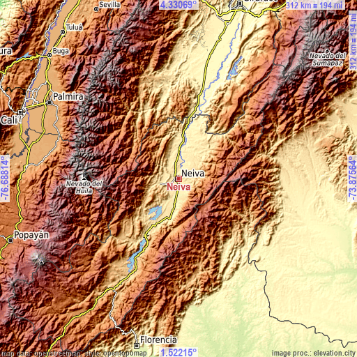
These maps also provides idea of topography and contour of this city, they are displayed at different zoom levels. More info about maps, scale and edge coordinates you can find below images.
| \ | Map #1 | Map #2 | Topo.Map |
| Scale [m] | 421..583 m | 410..962 m | × |
| Scale [ft] | 1381..1913 ft | 1345..3156 ft | × |
| Average | 470.4 m = 1543 ft | 501.4 m = 1645 ft | × |
| Width | 9.76 km = 6.1 mi | 19.52 km = 12.1 mi | 312.3 km = 194.1 mi |
| Height | 9.76 km = 6.1 mi | 19.52 km = 12.1 mi | 312.3 km = 194.1 mi |
| ↑Max Latitude | 2.971187° | 3.015072° | 4.33069° |
| Latitude at center | 2.9273° | 2.9273° | 2.9273° |
| ↓Min Latitude | 2.883411° | 2.839521° | 1.52215° |
| ← Min Longitude | -75.325835° | -75.369781° | -76.68814° |
| Longitude center | -75.28189° | -75.28189° | -75.28189° |
| →Max Longitude | -75.237945° | -75.193999° | -73.87564° |
Nearby cities:
Cities around Neiva sort by population:
• Campoalegre elevation 537 m
27.3 km,  189°
189°
• Palermo 546 m
17.7 km,  257°
257°
• Rivera 731 m
16.9 km,  170°
170°
• Aipe 393 m
33.2 km,  8°
8°
• Yaguará 578 m
39.3 km,  221°
221°
• Tello 581 m
22.3 km,  45°
45°
• Hobo 603 m
42.6 km,  206°
206°
• Baraya 612 m
35.7 km, 45°
• Teruel 875 m
37.8 km,  236°
236°
• Santa María 1745 m
41 km,  273°
273°
• Villavieja 384 m
33.4 km, 12°
• Santa María 1327 m
33.8 km, 272°
Multilingual:
 En español:
Neiva elevación 461 m.
 En France:
Neiva élévation 461 m.


Sources and notes:
- [note 1] Map square and city borders are not equal. Map elevation data is calculated only from area inside that square.
- [src 1] Elevation data from geonames database provided with same terms of usage.
- [src 2] The elevation map of Neiva is generated using elevation data from NASA's 3 arcsec (90m) resolution SRTM data.
- [src 3] Base (background) map © OpenStreetMap contributors tiles are generated by Geofabrik and OpenTopoMap.
Copyright & License:
This Neiva Elevation Map is licensed under CC BY-SA. You may reuse any part from this page, if you give a proper credit by linking to this URL:
 More info on terms of use page.