Amagá elevation
Amagá (Antioquia), Colombia elevation is 1370 meters and Amagá elevation in feet is 4495 ft above sea level [src 1]. Amagá is a seat of a second-order administrative division (feature code) with elevation that is 221 meters (725 ft) bigger than average city elevation in Colombia.
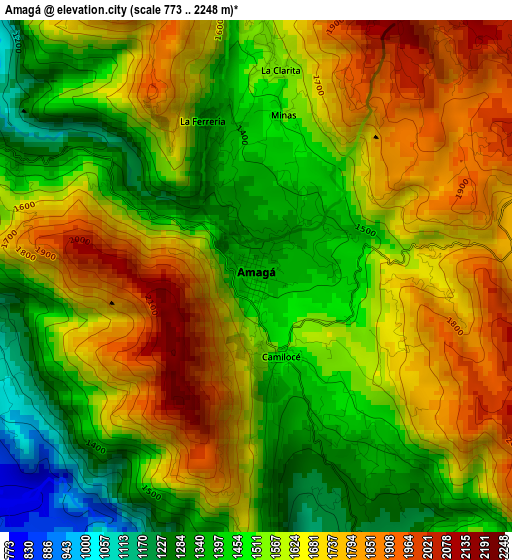
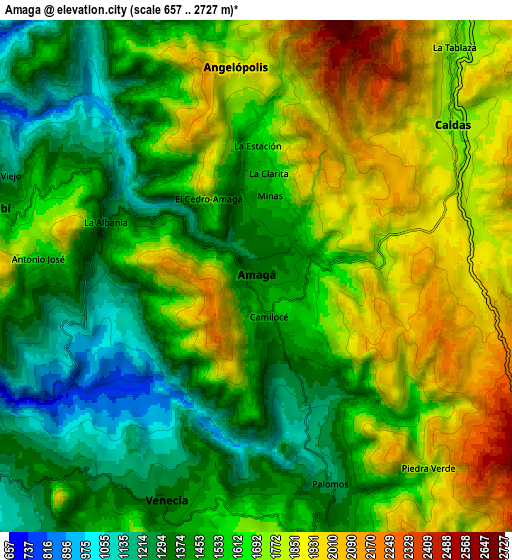
Below is the Elevation map of Amagá, which displays elevation range with different colors. Scale of the first map is from 773 to 2248 m (2536 to 7375 ft) with average elevation of 1580.9 meters (=5187 ft) [note 1]
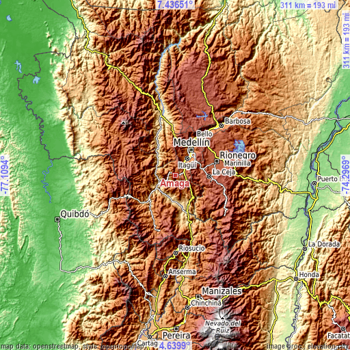
These maps also provides idea of topography and contour of this city, they are displayed at different zoom levels. More info about maps, scale and edge coordinates you can find below images.
| \ | Map #1 | Map #2 | Topo.Map |
| Scale [m] | 773..2248 m | 657..2727 m | × |
| Scale [ft] | 2536..7375 ft | 2156..8947 ft | × |
| Average | 1580.9 m = 5187 ft | 1604.3 m = 5263 ft | × |
| Width | 9.72 km = 6 mi | 19.44 km = 12.1 mi | 311 km = 193.2 mi |
| Height | 9.72 km = 6 mi | 19.44 km = 12.1 mi | 311 km = 193.2 mi |
| ↑Max Latitude | 6.08371° | 6.127406° | 7.43651° |
| Latitude at center | 6.04001° | 6.04001° | 6.04001° |
| ↓Min Latitude | 5.996307° | 5.9526° | 4.6399° |
| ← Min Longitude | -75.747095° | -75.791041° | -77.1094° |
| Longitude center | -75.70315° | -75.70315° | -75.70315° |
| →Max Longitude | -75.659205° | -75.615259° | -74.2969° |
Nearby cities:
Cities around Amagá sort by population:
• Itagüí elevation 1538 m
19.8 km,  35°
35°
• Envigado 1539 m
19.5 km, 39°
• Caldas 1756 m
9.4 km,  52°
52°
• La Estrella 1765 m
14.7 km,  26°
26°
• Sabaneta 1592 m
15.7 km, 37°
• Fredonia 1797 m
13.2 km,  164°
164°
• Venecia 1308 m
9.4 km,  204°
204°
• Titiribí 1540 m
10.3 km,  284°
284°
• Heliconia 1387 m
19.1 km,  349°
349°
• Armenia 1822 m
15.9 km,  324°
324°
• Montebello 2395 m
22 km,  117°
117°
• Angelópolis 1898 m
7.9 km,  355°
355°
Multilingual:
 En español:
Amagá elevación 1370 m.
 En France:
Amagá élévation 1370 m.


Sources and notes:
- [note 1] Map square and city borders are not equal. Map elevation data is calculated only from area inside that square.
- [src 1] Elevation data from geonames database provided with same terms of usage.
- [src 2] The elevation map of Amagá is generated using elevation data from NASA's 3 arcsec (90m) resolution SRTM data.
- [src 3] Base (background) map © OpenStreetMap contributors tiles are generated by Geofabrik and OpenTopoMap.
Copyright & License:
This Amagá Elevation Map is licensed under CC BY-SA. You may reuse any part from this page, if you give a proper credit by linking to this URL:
 More info on terms of use page.