La Estrella elevation
La Estrella (Antioquia), Colombia elevation is 1765 meters and La Estrella elevation in feet is 5791 ft above sea level [src 1]. La Estrella is a seat of a second-order administrative division (feature code) with elevation that is 616 meters (2021 ft) bigger than average city elevation in Colombia.
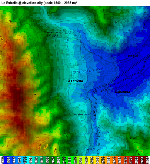
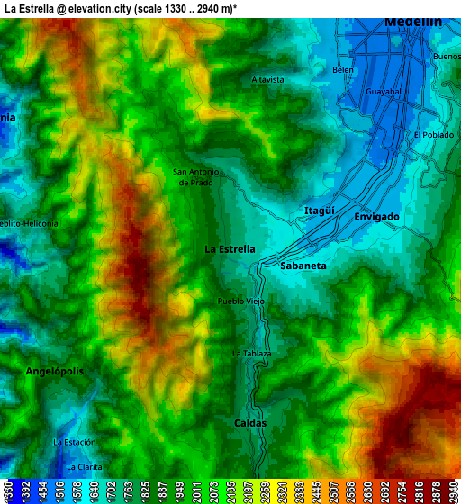
Below is the Elevation map of La Estrella, which displays elevation range with different colors. Scale of the first map is from 1540 to 2935 m (5052 to 9629 ft) with average elevation of 1989.5 meters (=6527 ft) [note 1]
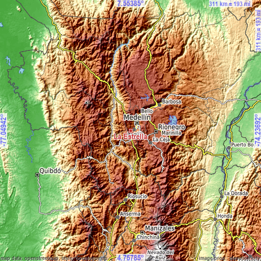
These maps also provides idea of topography and contour of this city, they are displayed at different zoom levels. More info about maps, scale and edge coordinates you can find below images.
| \ | Map #1 | Map #2 | Topo.Map |
| Scale [m] | 1540..2935 m | 1330..2940 m | × |
| Scale [ft] | 5052..9629 ft | 4364..9646 ft | × |
| Average | 1989.5 m = 6527 ft | 1967.7 m = 6456 ft | × |
| Width | 9.72 km = 6 mi | 19.43 km = 12.1 mi | 310.9 km = 193.2 mi |
| Height | 9.72 km = 6 mi | 19.43 km = 12.1 mi | 310.9 km = 193.2 mi |
| ↑Max Latitude | 6.20138° | 6.245066° | 7.55385° |
| Latitude at center | 6.15769° | 6.15769° | 6.15769° |
| ↓Min Latitude | 6.113996° | 6.070299° | 4.75785° |
| ← Min Longitude | -75.687115° | -75.731061° | -77.04942° |
| Longitude center | -75.64317° | -75.64317° | -75.64317° |
| →Max Longitude | -75.599225° | -75.555279° | -74.23692° |
Nearby cities:
Cities around La Estrella sort by population:
• Medellín elevation 1500 m
13.7 km,  40°
40°
• Bello 1456 m
22.1 km,  25°
25°
• Itagüí 1538 m
5.7 km,  58°
58°
• Envigado 1539 m
6 km,  70°
70°
• Caldas 1756 m
7.5 km,  173°
173°
• Sabaneta 1592 m
3 km,  103°
103°
• Amagá 1370 m
14.7 km,  206°
206°
• Retiro 2166 m
19 km,  125°
125°
• Titiribí 1540 m
19.7 km,  237°
237°
• Heliconia 1387 m
11.7 km,  298°
298°
• Armenia 1822 m
15.9 km,  269°
269°
• Angelópolis 1898 m
9 km,  234°
234°
Multilingual:
 En español:
La Estrella elevación 1765 m.
 En France:
La Estrella élévation 1765 m.
 Auf Deutsch:
La Estrella höhe über dem Meeresspiegel ist 1765 m.

Sources and notes:
- [note 1] Map square and city borders are not equal. Map elevation data is calculated only from area inside that square.
- [src 1] Elevation data from geonames database provided with same terms of usage.
- [src 2] The elevation map of La Estrella is generated using elevation data from NASA's 3 arcsec (90m) resolution SRTM data.
- [src 3] Base (background) map © OpenStreetMap contributors tiles are generated by Geofabrik and OpenTopoMap.
Copyright & License:
This La Estrella Elevation Map is licensed under CC BY-SA. You may reuse any part from this page, if you give a proper credit by linking to this URL:
 More info on terms of use page.