Andalucía elevation
Andalucía (Valle del Cauca), Colombia elevation is 958 meters and Andalucía elevation in feet is 3143 ft above sea level [src 1]. Andalucía is a seat of a second-order administrative division (feature code) with elevation that is 191 meters (627 ft) smaller than average city elevation in Colombia.
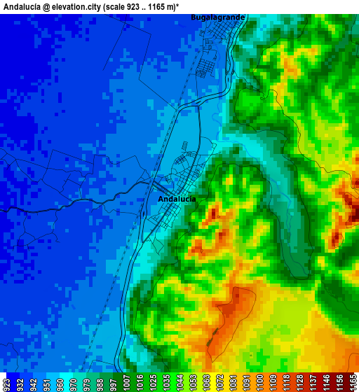
Below is the Elevation map of Andalucía, which displays elevation range with different colors. Scale of the first map is from 923 to 1165 m (3028 to 3822 ft) with average elevation of 987.4 meters (=3240 ft) [note 1]
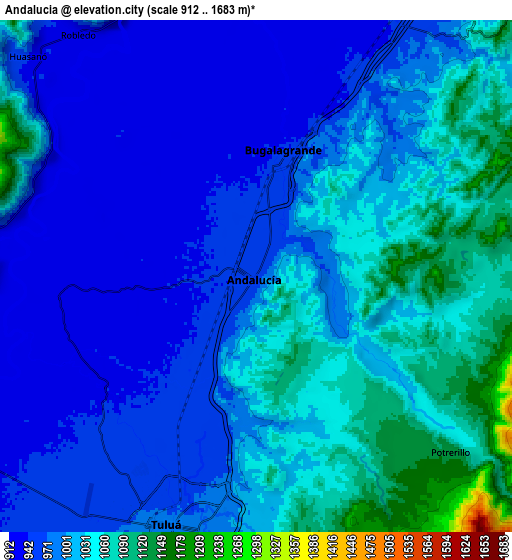
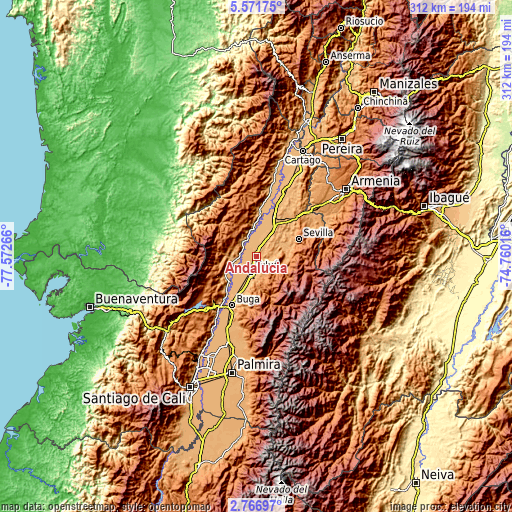
These maps also provides idea of topography and contour of this city, they are displayed at different zoom levels. More info about maps, scale and edge coordinates you can find below images.
| \ | Map #1 | Map #2 | Topo.Map |
| Scale [m] | 923..1165 m | 912..1683 m | × |
| Scale [ft] | 3028..3822 ft | 2992..5522 ft | × |
| Average | 987.4 m = 3240 ft | 1004 m = 3294 ft | × |
| Width | 9.75 km = 6.1 mi | 19.49 km = 12.1 mi | 311.9 km = 193.8 mi |
| Height | 9.75 km = 6.1 mi | 19.49 km = 12.1 mi | 311.9 km = 193.8 mi |
| ↑Max Latitude | 4.214438° | 4.258263° | 5.57175° |
| Latitude at center | 4.17061° | 4.17061° | 4.17061° |
| ↓Min Latitude | 4.12678° | 4.082947° | 2.76697° |
| ← Min Longitude | -76.210355° | -76.254301° | -77.57266° |
| Longitude center | -76.16641° | -76.16641° | -76.16641° |
| →Max Longitude | -76.122465° | -76.078519° | -74.76016° |
Nearby cities:
Cities around Andalucía sort by population:
• Tuluá elevation 974 m
10.1 km,  198°
198°
• Guadalajara de Buga 979 m
33.3 km,  205°
205°
• Sevilla 1617 m
28.1 km,  68°
68°
• Zarzal 921 m
27 km,  22°
22°
• Roldanillo 945 m
26.9 km,  2°
2°
• La Unión 967 m
40.9 km,  9°
9°
• Bugalagrande 948 m
4.8 km, 14°
• Riofrío 942 m
13.6 km,  263°
263°
• El Dovio 1435 m
38.3 km,  348°
348°
• Trujillo 1314 m
17.6 km,  285°
285°
• San Pedro 988 m
20.8 km, 199°
• Bolívar 931 m
18.8 km, 354°
Multilingual:
 En español:
Andalucía elevación 958 m.
 En France:
Andalucía élévation 958 m.
 Auf Deutsch:
Andalucía höhe über dem Meeresspiegel ist 958 m.

Sources and notes:
- [note 1] Map square and city borders are not equal. Map elevation data is calculated only from area inside that square.
- [src 1] Elevation data from geonames database provided with same terms of usage.
- [src 2] The elevation map of Andalucía is generated using elevation data from NASA's 3 arcsec (90m) resolution SRTM data.
- [src 3] Base (background) map © OpenStreetMap contributors tiles are generated by Geofabrik and OpenTopoMap.
Copyright & License:
This Andalucía Elevation Map is licensed under CC BY-SA. You may reuse any part from this page, if you give a proper credit by linking to this URL:
 More info on terms of use page.