Arbeláez elevation
Arbeláez (Cundinamarca), Colombia elevation is 1379 meters and Arbeláez elevation in feet is 4524 ft above sea level [src 1]. Arbeláez is a seat of a second-order administrative division (feature code) with elevation that is 230 meters (755 ft) bigger than average city elevation in Colombia.
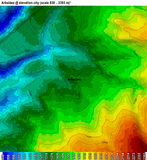
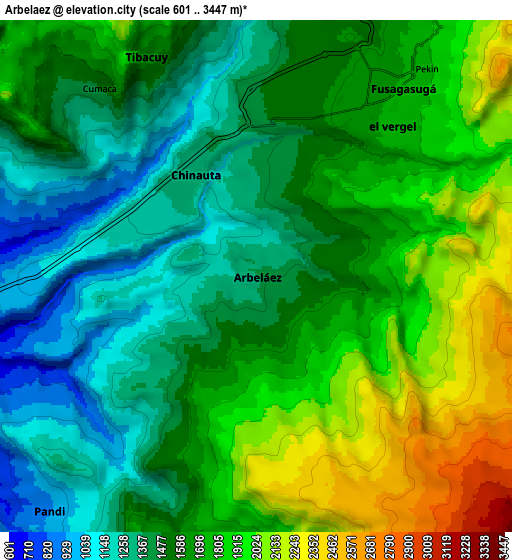
Below is the Elevation map of Arbeláez, which displays elevation range with different colors. Scale of the first map is from 838 to 2393 m (2749 to 7851 ft) with average elevation of 1467.9 meters (=4816 ft) [note 1]
These maps also provides idea of topography and contour of this city, they are displayed at different zoom levels. More info about maps, scale and edge coordinates you can find below images.
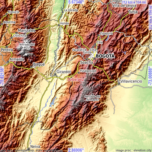
| \ | Map #1 | Map #2 | Topo.Map |
| Scale [m] | 838..2393 m | 601..3447 m | × |
| Scale [ft] | 2749..7851 ft | 1972..11309 ft | × |
| Average | 1467.9 m = 4816 ft | 1634.2 m = 5362 ft | × |
| Width | 9.75 km = 6.1 mi | 19.49 km = 12.1 mi | 311.8 km = 193.7 mi |
| Height | 9.75 km = 6.1 mi | 19.49 km = 12.1 mi | 311.9 km = 193.8 mi |
| ↑Max Latitude | 4.316362° | 4.360181° | 5.67346° |
| Latitude at center | 4.27254° | 4.27254° | 4.27254° |
| ↓Min Latitude | 4.228716° | 4.184889° | 2.86906° |
| ← Min Longitude | -74.459075° | -74.503021° | -75.82138° |
| Longitude center | -74.41513° | -74.41513° | -74.41513° |
| →Max Longitude | -74.371185° | -74.327239° | -73.00888° |
Nearby cities:
Cities around Arbeláez sort by population:
• Fusagasugá elevation 1717 m
9.1 km,  38°
38°
• Melgar 325 m
26.1 km,  253°
253°
• Silvania 1459 m
14.9 km,  12°
12°
• Viotá 568 m
21.8 km,  327°
327°
• Icononzo 1308 m
16.8 km,  230°
230°
• Pasca 2183 m
13.3 km,  73°
73°
• Pandi 922 m
12.1 km,  221°
221°
• Venecia 1641 m
21.6 km,  198°
198°
• Nilo 333 m
23.1 km,  279°
279°
• Granada 2279 m
28.4 km, 14°
• San Bernardo 1771 m
10.5 km,  184°
184°
• Tibacuy 1640 m
9.5 km, 334°
Multilingual:
 En español:
Arbeláez elevación 1379 m.
 En France:
Arbeláez élévation 1379 m.
 Auf Deutsch:
Arbeláez höhe über dem Meeresspiegel ist 1379 m.

Sources and notes:
- [note 1] Map square and city borders are not equal. Map elevation data is calculated only from area inside that square.
- [src 1] Elevation data from geonames database provided with same terms of usage.
- [src 2] The elevation map of Arbeláez is generated using elevation data from NASA's 3 arcsec (90m) resolution SRTM data.
- [src 3] Base (background) map © OpenStreetMap contributors tiles are generated by Geofabrik and OpenTopoMap.
Copyright & License:
This Arbeláez Elevation Map is licensed under CC BY-SA. You may reuse any part from this page, if you give a proper credit by linking to this URL:
 More info on terms of use page.