Icononzo elevation
Icononzo (Tolima), Colombia elevation is 1308 meters and Icononzo elevation in feet is 4291 ft above sea level [src 1]. Icononzo is a seat of a second-order administrative division (feature code) with elevation that is 159 meters (522 ft) bigger than average city elevation in Colombia.
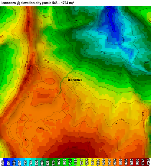
Below is the Elevation map of Icononzo, which displays elevation range with different colors. Scale of the first map is from 543 to 1794 m (1781 to 5886 ft) with average elevation of 1257.9 meters (=4127 ft) [note 1]
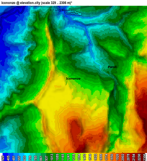
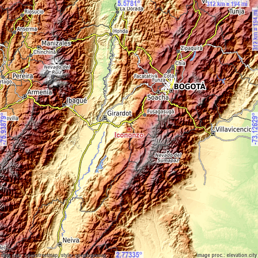
These maps also provides idea of topography and contour of this city, they are displayed at different zoom levels. More info about maps, scale and edge coordinates you can find below images.
| \ | Map #1 | Map #2 | Topo.Map |
| Scale [m] | 543..1794 m | 329..2306 m | × |
| Scale [ft] | 1781..5886 ft | 1079..7566 ft | × |
| Average | 1257.9 m = 4127 ft | 1162.8 m = 3815 ft | × |
| Width | 9.75 km = 6.1 mi | 19.49 km = 12.1 mi | 311.9 km = 193.8 mi |
| Height | 9.75 km = 6.1 mi | 19.49 km = 12.1 mi | 311.9 km = 193.8 mi |
| ↑Max Latitude | 4.220807° | 4.264632° | 5.5781° |
| Latitude at center | 4.17698° | 4.17698° | 4.17698° |
| ↓Min Latitude | 4.13315° | 4.089318° | 2.77335° |
| ← Min Longitude | -74.576485° | -74.620431° | -75.93879° |
| Longitude center | -74.53254° | -74.53254° | -74.53254° |
| →Max Longitude | -74.488595° | -74.444649° | -73.12629° |
Nearby cities:
Cities around Icononzo sort by population:
• Fusagasugá elevation 1717 m
25.8 km,  46°
46°
• Melgar 325 m
12.4 km,  284°
284°
• Agua de Dios 384 m
26.9 km,  325°
325°
• Carmen de Apicalá 315 m
21.1 km,  260°
260°
• Arbeláez 1379 m
16.8 km, 50°
• Cunday 457 m
22 km,  233°
233°
• Cabrera 1879 m
21.9 km,  165°
165°
• Pandi 922 m
5.2 km,  72°
72°
• Venecia 1641 m
11.6 km,  148°
148°
• Nilo 333 m
17.4 km, 325°
• Tibacuy 1640 m
21.2 km,  24°
24°
• San Bernardo 1771 m
12.1 km,  89°
89°
Multilingual:
 En español:
Icononzo elevación 1308 m.
 En France:
Icononzo élévation 1308 m.
 Auf Deutsch:
Icononzo höhe über dem Meeresspiegel ist 1308 m.

Sources and notes:
- [note 1] Map square and city borders are not equal. Map elevation data is calculated only from area inside that square.
- [src 1] Elevation data from geonames database provided with same terms of usage.
- [src 2] The elevation map of Icononzo is generated using elevation data from NASA's 3 arcsec (90m) resolution SRTM data.
- [src 3] Base (background) map © OpenStreetMap contributors tiles are generated by Geofabrik and OpenTopoMap.
Copyright & License:
This Icononzo Elevation Map is licensed under CC BY-SA. You may reuse any part from this page, if you give a proper credit by linking to this URL:
 More info on terms of use page.