Barbacoas elevation
Barbacoas (Nariño), Colombia elevation is 37 meters and Barbacoas elevation in feet is 121 ft above sea level [src 1]. Barbacoas is a seat of a second-order administrative division (feature code) with elevation that is 1112 meters (3648 ft) smaller than average city elevation in Colombia.
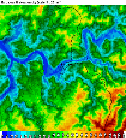
Below is the Elevation map of Barbacoas, which displays elevation range with different colors. Scale of the first map is from 14 to 231 m (46 to 758 ft) with average elevation of 95.6 meters (=314 ft) [note 1]
These maps also provides idea of topography and contour of this city, they are displayed at different zoom levels. More info about maps, scale and edge coordinates you can find below images.
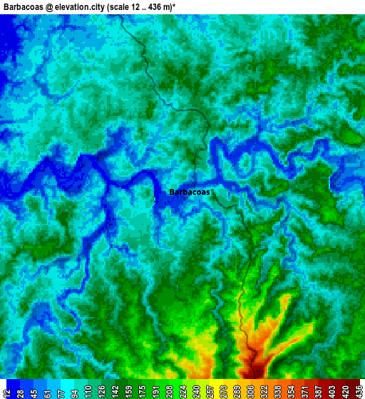
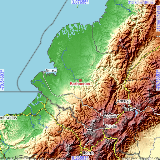
| \ | Map #1 | Map #2 | Topo.Map |
| Scale [m] | 14..231 m | 12..436 m | × |
| Scale [ft] | 46..758 ft | 39..1430 ft | × |
| Average | 95.6 m = 314 ft | 115.8 m = 380 ft | × |
| Width | 9.77 km = 6.1 mi | 19.54 km = 12.1 mi | 312.6 km = 194.2 mi |
| Height | 9.77 km = 6.1 mi | 19.54 km = 12.1 mi | 312.6 km = 194.2 mi |
| ↑Max Latitude | 1.715466° | 1.759391° | 3.07655° |
| Latitude at center | 1.67154° | 1.67154° | 1.67154° |
| ↓Min Latitude | 1.627613° | 1.583685° | 0.26553° |
| ← Min Longitude | -78.183725° | -78.227671° | -79.54603° |
| Longitude center | -78.13978° | -78.13978° | -78.13978° |
| →Max Longitude | -78.095835° | -78.051889° | -76.73353° |
Nearby cities:
Cities around Barbacoas sort by population:
• Tumaco elevation 1 m
73.8 km,  280°
280°
• Samaniego 1459 m
70.9 km,  121°
121°
• Salahonda 5 m
70.8 km,  305°
305°
• Sotomayor 1201 m
71.5 km,  105°
105°
• Payán 85 m
11.6 km,  335°
335°
• La Llanada 1978 m
66 km, 109°
• Ricaurte 1560 m
53.2 km,  162°
162°
• Policarpa 856 m
75.8 km,  93°
93°
• Piedrancha 2157 m
66.4 km,  152°
152°
• San José 39 m
12 km, 283°
• Cumbitara 1683 m
62.5 km, 92°
• Guachavés 2490 m
71.6 km,  134°
134°
Multilingual:
 En español:
Barbacoas elevación 37 m.
 En France:
Barbacoas élévation 37 m.
 Auf Deutsch:
Barbacoas höhe über dem Meeresspiegel ist 37 m.

Sources and notes:
- [note 1] Map square and city borders are not equal. Map elevation data is calculated only from area inside that square.
- [src 1] Elevation data from geonames database provided with same terms of usage.
- [src 2] The elevation map of Barbacoas is generated using elevation data from NASA's 3 arcsec (90m) resolution SRTM data.
- [src 3] Base (background) map © OpenStreetMap contributors tiles are generated by Geofabrik and OpenTopoMap.
Copyright & License:
This Barbacoas Elevation Map is licensed under CC BY-SA. You may reuse any part from this page, if you give a proper credit by linking to this URL:
 More info on terms of use page.