Piedrancha elevation
Piedrancha (Nariño, Mallama), Colombia elevation is 2157 meters and Piedrancha elevation in feet is 7077 ft above sea level [src 1]. Piedrancha is a seat of a second-order administrative division (feature code) with elevation that is 1008 meters (3307 ft) bigger than average city elevation in Colombia.
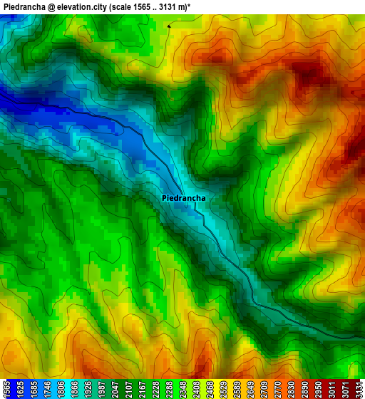
Below is the Elevation map of Piedrancha, which displays elevation range with different colors. Scale of the first map is from 1565 to 3131 m (5135 to 10272 ft) with average elevation of 2302.1 meters (=7553 ft) [note 1]
These maps also provides idea of topography and contour of this city, they are displayed at different zoom levels. More info about maps, scale and edge coordinates you can find below images.
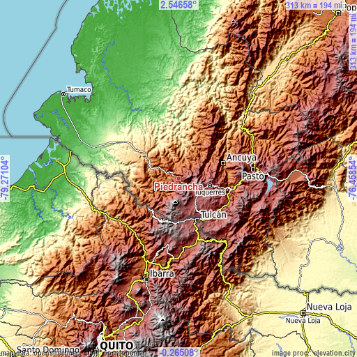
| \ | Map #1 | Topo.Map |
| Scale [m] | 1565..3131 m | × |
| Scale [ft] | 5135..10272 ft | × |
| Average | 2302.1 m = 7553 ft | × |
| Width | 9.77 km = 6.1 mi | 312.6 km = 194.2 mi |
| Height | 9.77 km = 6.1 mi | 312.7 km = 194.3 mi |
| ↑Max Latitude | 1.185026° | 2.54658° |
| Latitude at center | 1.14109° | 1.14109° |
| ↓Min Latitude | 1.097153° | -0.26508° |
| ← Min Longitude | -77.908735° | -79.27104° |
| Longitude center | -77.86479° | -77.86479° |
| →Max Longitude | -77.820845° | -76.45854° |
Nearby cities:
Cities around Piedrancha sort by population:
• Túquerres elevation 3106 m
28 km,  102°
102°
• Samaniego 1459 m
37.1 km,  53°
53°
• Cumbal 3127 m
27.1 km,  162°
162°
• Guaitarilla 2627 m
35.2 km,  91°
91°
• Guachucal 3091 m
24.9 km,  143°
143°
• Ospina 2862 m
34.5 km,  105°
105°
• Sapuyes 2995 m
29.5 km, 113°
• Ricaurte 1560 m
16.9 km,  298°
298°
• Carlosama 3027 m
34.5 km,  153°
153°
• Aldana 3016 m
34 km, 147°
• Providencia 2312 m
31.7 km,  69°
69°
• Guachavés 2490 m
22.7 km, 66°
Multilingual:
 En español:
Piedrancha elevación 2157 m.
 En France:
Piedrancha élévation 2157 m.
 Auf Deutsch:
Piedrancha höhe über dem Meeresspiegel ist 2157 m.

Sources and notes:
- [note 1] Map square and city borders are not equal. Map elevation data is calculated only from area inside that square.
- [src 1] Elevation data from geonames database provided with same terms of usage.
- [src 2] The elevation map of Piedrancha is generated using elevation data from NASA's 3 arcsec (90m) resolution SRTM data.
- [src 3] Base (background) map © OpenStreetMap contributors tiles are generated by Geofabrik and OpenTopoMap.
Copyright & License:
This Piedrancha Elevation Map is licensed under CC BY-SA. You may reuse any part from this page, if you give a proper credit by linking to this URL:
 More info on terms of use page.