Caparrapí elevation
Caparrapí (Cundinamarca), Colombia elevation is 1265 meters and Caparrapí elevation in feet is 4150 ft above sea level [src 1]. Caparrapí is a seat of a second-order administrative division (feature code) with elevation that is 116 meters (381 ft) bigger than average city elevation in Colombia.
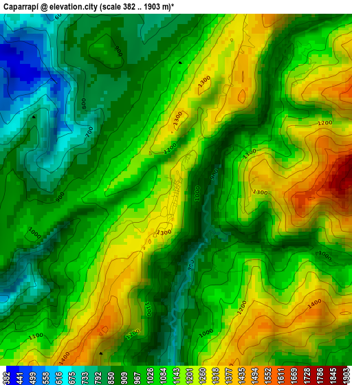
Below is the Elevation map of Caparrapí, which displays elevation range with different colors. Scale of the first map is from 382 to 1903 m (1253 to 6243 ft) with average elevation of 1063.5 meters (=3489 ft) [note 1]
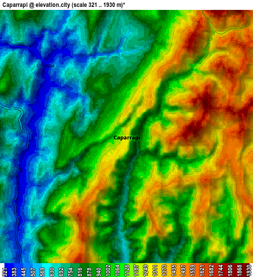
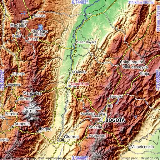
These maps also provides idea of topography and contour of this city, they are displayed at different zoom levels. More info about maps, scale and edge coordinates you can find below images.
| \ | Map #1 | Map #2 | Topo.Map |
| Scale [m] | 382..1903 m | 321..1930 m | × |
| Scale [ft] | 1253..6243 ft | 1053..6332 ft | × |
| Average | 1063.5 m = 3489 ft | 1005.6 m = 3299 ft | × |
| Width | 9.73 km = 6 mi | 19.46 km = 12.1 mi | 311.3 km = 193.4 mi |
| Height | 9.73 km = 6 mi | 19.46 km = 12.1 mi | 311.4 km = 193.5 mi |
| ↑Max Latitude | 5.390193° | 5.433942° | 6.74483° |
| Latitude at center | 5.34644° | 5.34644° | 5.34644° |
| ↓Min Latitude | 5.302684° | 5.258926° | 3.94485° |
| ← Min Longitude | -74.535415° | -74.579361° | -75.89772° |
| Longitude center | -74.49147° | -74.49147° | -74.49147° |
| →Max Longitude | -74.447525° | -74.403579° | -73.08522° |
Nearby cities:
Cities around Caparrapí sort by population:
• La Dorada elevation 176 m
22.1 km,  300°
300°
• Puerto Salgar 177 m
22.2 km,  305°
305°
• Cachipay 389 m
12.2 km,  223°
223°
• Yacopí 1281 m
21.1 km,  53°
53°
• Útica 503 m
17.7 km,  176°
176°
• Vergara 1553 m
30.1 km,  147°
147°
• La Peña 1254 m
19.7 km, 146°
• Topaipí 1267 m
20.9 km,  93°
93°
• Quebradanegra 1356 m
25.5 km, 177°
• El Peñón 1444 m
24.6 km,  115°
115°
• Nimaima 1107 m
27.2 km, 154°
• La Palma 1447 m
11.3 km,  82°
82°
Multilingual:
 En español:
Caparrapí elevación 1265 m.
 En France:
Caparrapí élévation 1265 m.
 Auf Deutsch:
Caparrapí höhe über dem Meeresspiegel ist 1265 m.

Sources and notes:
- [note 1] Map square and city borders are not equal. Map elevation data is calculated only from area inside that square.
- [src 1] Elevation data from geonames database provided with same terms of usage.
- [src 2] The elevation map of Caparrapí is generated using elevation data from NASA's 3 arcsec (90m) resolution SRTM data.
- [src 3] Base (background) map © OpenStreetMap contributors tiles are generated by Geofabrik and OpenTopoMap.
Copyright & License:
This Caparrapí Elevation Map is licensed under CC BY-SA. You may reuse any part from this page, if you give a proper credit by linking to this URL:
 More info on terms of use page.