Cartago elevation
Cartago (Valle del Cauca), Colombia elevation is 915 meters and Cartago elevation in feet is 3002 ft above sea level [src 1]. Cartago is a seat of a second-order administrative division (feature code) with elevation that is 234 meters (768 ft) smaller than average city elevation in Colombia.
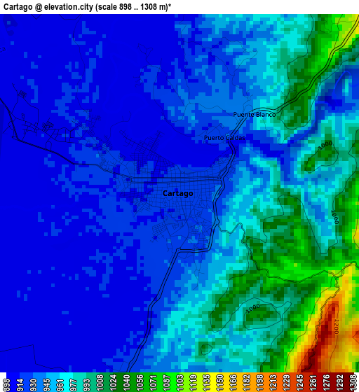
Below is the Elevation map of Cartago, which displays elevation range with different colors. Scale of the first map is from 898 to 1308 m (2946 to 4291 ft) with average elevation of 952.2 meters (=3124 ft) [note 1]
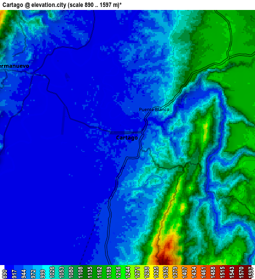
These maps also provides idea of topography and contour of this city, they are displayed at different zoom levels. More info about maps, scale and edge coordinates you can find below images.
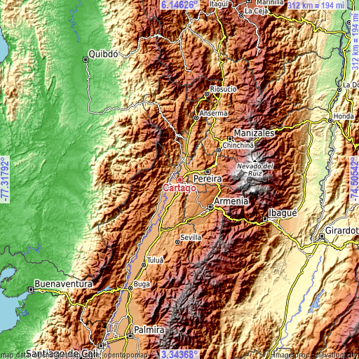
| \ | Map #1 | Map #2 | Topo.Map |
| Scale [m] | 898..1308 m | 890..1597 m | × |
| Scale [ft] | 2946..4291 ft | 2920..5240 ft | × |
| Average | 952.2 m = 3124 ft | 993.5 m = 3260 ft | × |
| Width | 9.74 km = 6.1 mi | 19.48 km = 12.1 mi | 311.6 km = 193.6 mi |
| Height | 9.74 km = 6.1 mi | 19.48 km = 12.1 mi | 311.6 km = 193.6 mi |
| ↑Max Latitude | 4.790183° | 4.833974° | 6.14626° |
| Latitude at center | 4.74639° | 4.74639° | 4.74639° |
| ↓Min Latitude | 4.702594° | 4.658795° | 3.34368° |
| ← Min Longitude | -75.955615° | -75.999561° | -77.31792° |
| Longitude center | -75.91167° | -75.91167° | -75.91167° |
| →Max Longitude | -75.867725° | -75.823779° | -74.50542° |
Nearby cities:
Cities around Cartago sort by population:
• Pereira elevation 1414 m
25 km,  72°
72°
• Montenegro 1297 m
26.8 km,  138°
138°
• La Virginia 901 m
17.4 km,  10°
10°
• Quimbaya 1313 m
21.5 km,  129°
129°
• Toro 992 m
24 km,  231°
231°
• Ansermanuevo 971 m
10.8 km,  301°
301°
• Alcalá 1235 m
16.4 km,  119°
119°
• Obando 932 m
20.2 km,  199°
199°
• Argelia 1623 m
23.1 km,  263°
263°
• El Águila 1708 m
23.4 km,  322°
322°
• Ulloa 1353 m
19.6 km,  103°
103°
• Balboa 1791 m
23.2 km,  347°
347°
Multilingual:
 En español:
Cartago elevación 915 m.
 En France:
Cartago élévation 915 m.


Sources and notes:
- [note 1] Map square and city borders are not equal. Map elevation data is calculated only from area inside that square.
- [src 1] Elevation data from geonames database provided with same terms of usage.
- [src 2] The elevation map of Cartago is generated using elevation data from NASA's 3 arcsec (90m) resolution SRTM data.
- [src 3] Base (background) map © OpenStreetMap contributors tiles are generated by Geofabrik and OpenTopoMap.
Copyright & License:
This Cartago Elevation Map is licensed under CC BY-SA. You may reuse any part from this page, if you give a proper credit by linking to this URL:
 More info on terms of use page.