Toro elevation
Toro (Valle del Cauca), Colombia elevation is 992 meters and Toro elevation in feet is 3255 ft above sea level [src 1]. Toro is a seat of a second-order administrative division (feature code) with elevation that is 157 meters (515 ft) smaller than average city elevation in Colombia.
Below is the Elevation map of Toro, which displays elevation range with different colors. Scale of the first map is from 900 to 1958 m (2953 to 6424 ft) with average elevation of 1116.9 meters (=3664 ft) [note 1]
These maps also provides idea of topography and contour of this city, they are displayed at different zoom levels. More info about maps, scale and edge coordinates you can find below images.
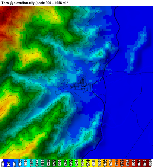
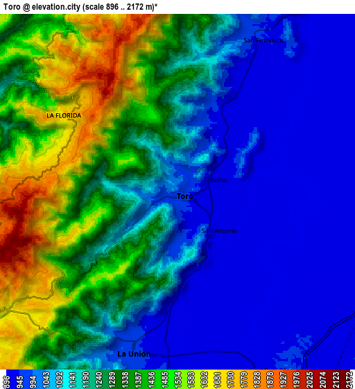
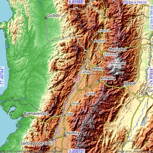
| \ | Map #1 | Map #2 | Topo.Map |
| Scale [m] | 900..1958 m | 896..2172 m | × |
| Scale [ft] | 2953..6424 ft | 2940..7126 ft | × |
| Average | 1116.9 m = 3664 ft | 1207.5 m = 3962 ft | × |
| Width | 9.74 km = 6.1 mi | 19.48 km = 12.1 mi | 311.7 km = 193.7 mi |
| Height | 9.74 km = 6.1 mi | 19.48 km = 12.1 mi | 311.7 km = 193.7 mi |
| ↑Max Latitude | 4.655472° | 4.699271° | 6.01185° |
| Latitude at center | 4.61167° | 4.61167° | 4.61167° |
| ↓Min Latitude | 4.567866° | 4.524059° | 3.20873° |
| ← Min Longitude | -76.125335° | -76.169281° | -77.48764° |
| Longitude center | -76.08139° | -76.08139° | -76.08139° |
| →Max Longitude | -76.037445° | -75.993499° | -74.67514° |
Nearby cities:
Cities around Toro sort by population:
• Cartago elevation 915 m
24 km,  51°
51°
• Zarzal 921 m
24.2 km,  177°
177°
• Roldanillo 945 m
23.6 km,  200°
200°
• La Unión 967 m
9.1 km, 195°
• Ansermanuevo 971 m
22.7 km,  24°
24°
• La Victoria 911 m
10.7 km,  154°
154°
• El Dovio 1435 m
20.7 km,  236°
236°
• Obando 932 m
12.6 km,  108°
108°
• Bolívar 931 m
32.4 km, 200°
• Versalles 1840 m
13.6 km,  252°
252°
• Argelia 1623 m
13.1 km,  341°
341°
• El Cairo 1924 m
22.8 km,  317°
317°
Multilingual:
 En español:
Toro elevación 992 m.
 En France:
Toro élévation 992 m.


Sources and notes:
- [note 1] Map square and city borders are not equal. Map elevation data is calculated only from area inside that square.
- [src 1] Elevation data from geonames database provided with same terms of usage.
- [src 2] The elevation map of Toro is generated using elevation data from NASA's 3 arcsec (90m) resolution SRTM data.
- [src 3] Base (background) map © OpenStreetMap contributors tiles are generated by Geofabrik and OpenTopoMap.
Copyright & License:
This Toro Elevation Map is licensed under CC BY-SA. You may reuse any part from this page, if you give a proper credit by linking to this URL:
 More info on terms of use page.