Chigorodó elevation
Chigorodó (Antioquia), Colombia elevation is 35 meters and Chigorodó elevation in feet is 115 ft above sea level [src 1]. Chigorodó is a seat of a second-order administrative division (feature code) with elevation that is 1114 meters (3655 ft) smaller than average city elevation in Colombia.
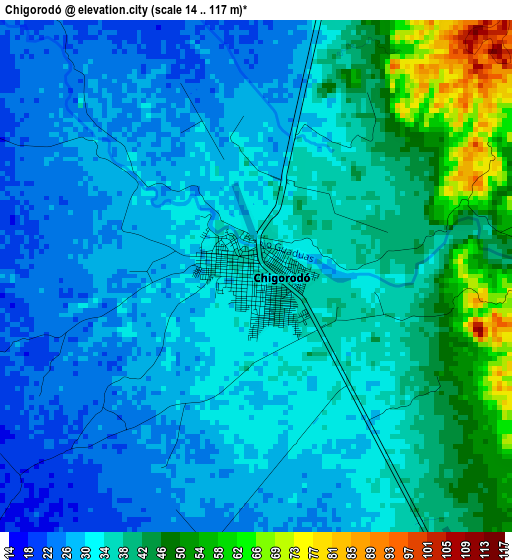
Below is the Elevation map of Chigorodó, which displays elevation range with different colors. Scale of the first map is from 14 to 117 m (46 to 384 ft) with average elevation of 34.5 meters (=113 ft) [note 1]
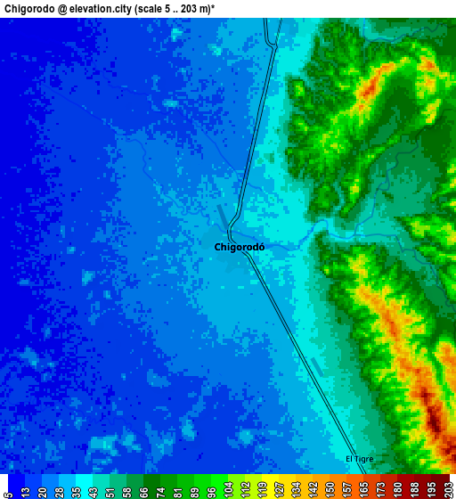
These maps also provides idea of topography and contour of this city, they are displayed at different zoom levels. More info about maps, scale and edge coordinates you can find below images.
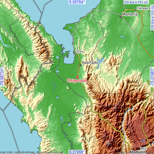
| \ | Map #1 | Map #2 | Topo.Map |
| Scale [m] | 14..117 m | 5..203 m | × |
| Scale [ft] | 46..384 ft | 16..666 ft | × |
| Average | 34.5 m = 113 ft | 40.4 m = 133 ft | × |
| Width | 9.69 km = 6 mi | 19.37 km = 12 mi | 309.9 km = 192.6 mi |
| Height | 9.69 km = 6 mi | 19.37 km = 12 mi | 309.9 km = 192.6 mi |
| ↑Max Latitude | 7.70993° | 7.753476° | 9.05764° |
| Latitude at center | 7.66638° | 7.66638° | 7.66638° |
| ↓Min Latitude | 7.622825° | 7.579266° | 6.27055° |
| ← Min Longitude | -76.725005° | -76.768951° | -78.08731° |
| Longitude center | -76.68106° | -76.68106° | -76.68106° |
| →Max Longitude | -76.637115° | -76.593169° | -75.27481° |
Nearby cities:
Cities around Chigorodó sort by population:
• Apartadó elevation 31 m
24.8 km,  14°
14°
• Turbo 6 m
47.7 km,  353°
353°
• Carepa 38 m
10.7 km,  17°
17°
• Dabeiba 488 m
86.9 km,  148°
148°
• San Pedro de Urabá 141 m
75.5 km,  26°
26°
• Necoclí 4 m
85.3 km, 351°
• Valencia 62 m
88.1 km,  41°
41°
• Riosucio 2 m
54.3 km,  242°
242°
• Mutatá 132 m
54.2 km, 150°
• Unguía 14 m
61.7 km,  312°
312°
• Murindó 45 m
77.8 km,  191°
191°
• Curbaradó 7 m
65 km,  209°
209°
Multilingual:
 En español:
Chigorodó elevación 35 m.
 En France:
Chigorodó élévation 35 m.
 Auf Deutsch:
Chigorodó höhe über dem Meeresspiegel ist 35 m.

Sources and notes:
- [note 1] Map square and city borders are not equal. Map elevation data is calculated only from area inside that square.
- [src 1] Elevation data from geonames database provided with same terms of usage.
- [src 2] The elevation map of Chigorodó is generated using elevation data from NASA's 3 arcsec (90m) resolution SRTM data.
- [src 3] Base (background) map © OpenStreetMap contributors tiles are generated by Geofabrik and OpenTopoMap.
Copyright & License:
This Chigorodó Elevation Map is licensed under CC BY-SA. You may reuse any part from this page, if you give a proper credit by linking to this URL:
 More info on terms of use page.